Contact | RSS | EN | DE | EL | ES | FR | IT | RU

Pelée Volcano

Updated: May 2, 2024 13:02 GMT -
Stratovolcano 1397 m / 4,583 ft
West Indies, France, 14.82°N / -61.17°W
Current status: restless (2 out of 5)
Last update: 22 Dec 2021 (weak seismic unrest)

[smaller] [larger]
Typical eruption style: unspecified
Pelée volcano eruptions: 1929-32

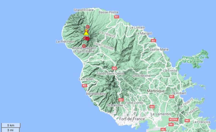
Latest nearby earthquakes

TimeMag. / DepthDistance / Location
Apr 28, 05:34 pm (Martinique)
0.2

0.6 km
Martinique: near Fort-de-France
Info
Apr 28, 10:53 am (Martinique)
0.2

0 km
Martinique: near Fort-de-France
Info
Saturday, April 27, 2024 GMT (2 quakes)
Apr 27, 02:41 pm (Martinique)
0.6

0.1 km
Martinique: near Fort-de-France
Info
Apr 26, 08:23 pm (Martinique)
0.3

0.1 km
Martinique: near Fort-de-France
Info
Thursday, April 25, 2024 GMT (1 quake)
Apr 25, 04:23 pm (Martinique)
0.5

0.1 km
Martinique: near Fort-de-France
Info
Tuesday, April 23, 2024 GMT (1 quake)
Apr 22, 08:41 pm (Martinique)
0.2

0.5 km
Martinique: near Fort-de-France
Info

Background

Renowned Montagne Pelée, forming the northern end of the island of Martinique, is the most active volcano of the Lesser Antilles arc. Three major edifice failures since the late Pleistocene, the last about 9000 years ago, have left large horseshoe-shaped calderas breached to the SW inside which the modern volcano has been constructed. More than 20 major eruptions have occurred at Pelée during the past 5000 years. Extensive pyroclastic-flow deposits, incised by steep-walled ravines, mantle the slopes of the volcano. The l'Etang Sec summit crater is filled by two lava domes emplaced during the 1902 and 1929 eruptions. Historical eruptions date back to the 18th century; only two modest phreatic or phreatomagmatic eruptions took place prior to 1902. The catastrophic 1902 eruption, which destroyed the city of St. Pierre, the "Pearl of the Lesser Antilles," became the type-example of pelean eruptions and marked the onset of modern volcanological studies of the behavior of pyroclastic flows.
---
Smithsonian / GVP volcano information

Pelée Volcano Photos
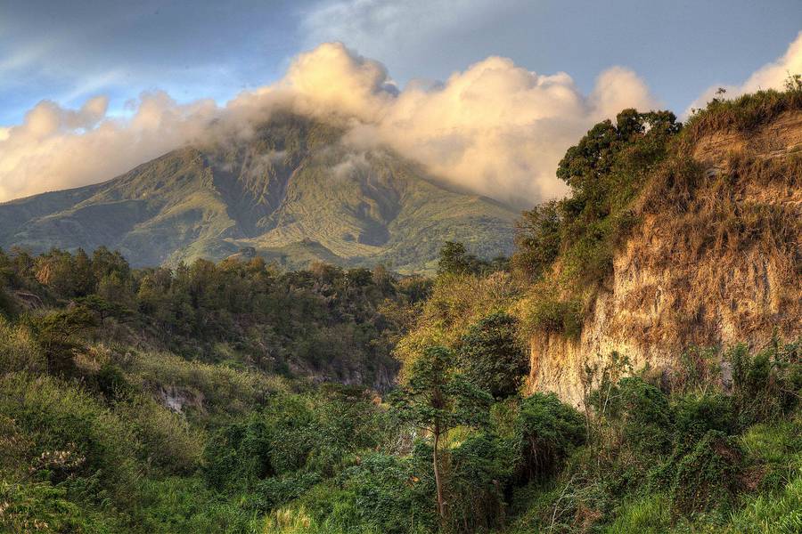
Latest satellite images

pelee satellite image sat1pelee satellite image sat2
Thu, 10 Jun 2021, 06:36

Mt Pelée volcano (Martinique Island): small tremors continue as signs of volcanic unrest

Location of earthquakes under Mt Pelée during the past 14 days
The volcano remains restless. Seismic activity continues to be slightly above background levels, showing that the volcano might be potentially preparing itself for new activity in a medium-term future (months or years from now). ... Read all
Wed, 24 Mar 2021, 06:00

Pelee volcano (Martinique, France) - Smithsonian / USGS Weekly Volcanic Activity Report for 24 March-30 March 2021 (New Activity / Unrest)

L'Observatoire Volcanologique et Sismologique de Martinique (OVSM) reported that seismicity at Pelée increased during 19-26 March. The seismic network recorded at least 55 high-frequency volcano-tectonic earthquakes with magnitudes less than or equal to 1, located at depths between 1.7 km below sea level and 1 km above sea level. The Alert Level remained at Yellow (the second lowest level on a four-color scale). ... Read all

On this page:

Try our free app!
Volcanoes & Earthquakes - new app for Android
Android | iOS version

More on VolcanoDiscovery

Why is there advertising on this site?

Support us - Help us upgrade our services!

We truly love working to bring you the latest volcano and earthquake data from around the world. Maintaining our website and our free apps does require, however, considerable time and resources.
We need financing to increase hard- and software capacity as well as support our editor team. We're aiming to achieve uninterrupted service wherever an earthquake or volcano eruption unfolds, and your donations can make it happen! Every donation will be highly appreciated. If you find the information useful and would like to support our team in integrating further features, write great content, and in upgrading our soft- and hardware, please make a donation (PayPal or Online credit card payment).

Planned features:Thanks to your past donations, these features have been added recently:
Download and Upgrade the Volcanoes & Earthquakes app to get one of the fastest seismic and volcano alerts online:
Android | IOS
Thank you!
Sources: VolcanoDiscovery / VolcanoAdventures and other sources as noted.
Use of material: Most text and images on our websites are owned by us. Re-use is generally not permitted without authorization. Contact us for licensing rights.
Volcanoes & Earthquakes
VolcanoDiscovery Home
Volcanoes | Earthquakes | Photos | Volcano News | App
Adventure & Study Travel
Tours to Volcanoes and Volcanic Areas: walking tours, photo tours, study tours
Tours & Dates | FAQ | About us
Get our newsletter!
Company info
Contact | Legal info | Terms & conditions
Follow us
Follow us on facebook Follow us on Instagram Follow us on Twitter Visit our Youtube channel
EN | DE | EL | ES | FR | IT | RU
VolcanoDiscovery GmbH, Germany, Reg. nr.: HRB 103744, EU Tax Id: DE 297 465 123 owned and created by
Dr. Tom Pfeiffer, volcanologist, volcano photographer, tour organizer member of
IAVCEI
IAVCEI
Vulkanologische Gesellschaft
Volcanological Society
Ecotourism Greece
Ecotourism Greece
RUV insurance
Insured by R+V
VolcanoDiscovery © 2004- All Rights Reserved | Privacy - Cookie Settings