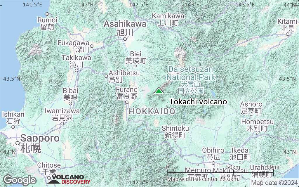
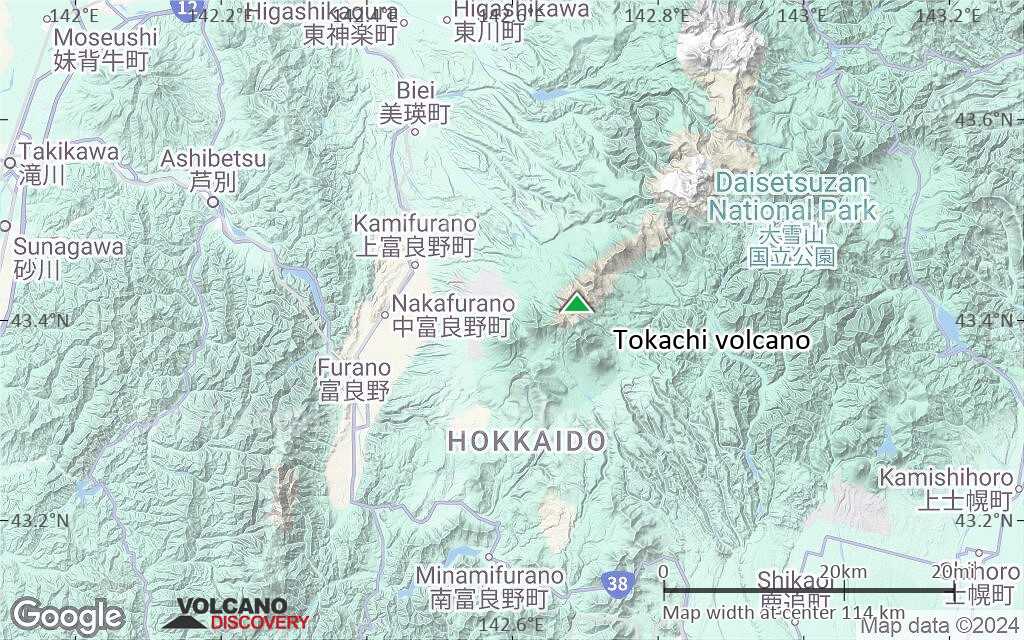
| RSS | EN | DE | EL | ES | FR | IT | RU

Tokachi Volcano

Updated: Jun 10, 2025 13:25 GMT -
stratovolcanoes
Hokkaido (Japan), 43.42°N / 142.69°E
Summit height: 2077 m / 6,814 ft
Current status: normal or dormant (1 out of 5)
Last update: 11 Mar 2022 (alert level raised)

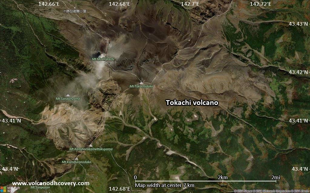
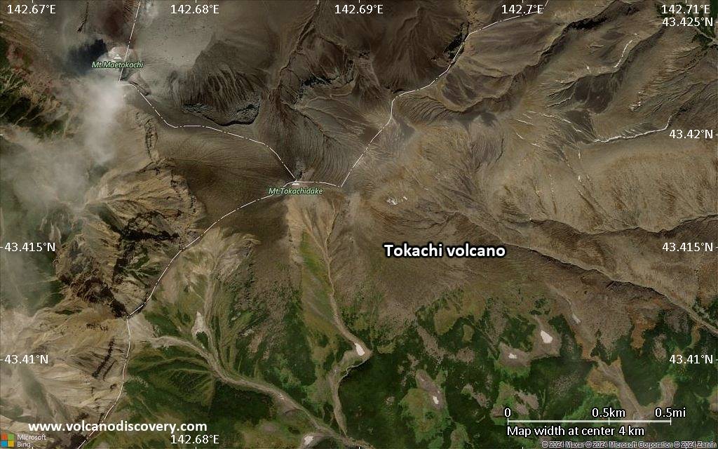
Tokachi volcano (十勝岳 Tokachidake) is a group of stratovolcanoes and lava domes in central Hokkaido, Japan.
Frequent historical eruptions were mostly small to moderate phreatic explosions (VEI 1-2) and cluster in 5 periods: 1857, 1887 and 1889, 1925-1931, 1952 to 1962, and 1985 and 1989. 3 eruptions generated pyroclastic flows, but only the 1670 eruption produced lava flows.
Larger eruptions were in 1926 and 1962 and caused damage and fatalities. Partial cone collapse of the western flank of Tokachi-dake during the 1926 eruption produced a disastrous debris avalanche and lahar that killed more than 140 people.

The fields near Tokachi are a popular spot for photographers and tourists for viewing lavender fields.

[smaller] [larger]
Typical eruption style: explosive
Tokachi volcano eruptions: 2004, 1988-89, 1985, 1962, 1961, 1959, 1958, 1957, 1956, 1954, 1952, 1931,
1928, 1928, 1925-27, 1889, 1887, 1857

Latest nearby earthquakes

Date and TimeMag / DepthDistance / Location
Jun 10, 07:27 pm (GMT +9)
0.9

30 km
5.2 km (3.2 mi) to the W 45 km southeast of Asahikawa, Hokkaido, Japan Info
Monday, June 9, 2025 GMT (1 quake)
Jun 10, 04:02 am (GMT +9)
0.1

1.4 km
3.6 km (2.2 mi) to the SW Japan: Taisetsu Mountains Region Info
Tuesday, June 3, 2025 GMT (1 quake)
Jun 4, 08:39 am (GMT +9)
3.1

154 km
18 km (10.9 mi) to the SW Japan: Kamikawa-Sorachi Region  I FELT IT Info
Monday, June 2, 2025 GMT (1 quake)
Jun 2, 10:25 am (GMT +9)
1.4

5.5 km
5.5 km (3.4 mi) to the W Japan: Taisetsu Mountains Region Info

Background

The Tokachi volcano group volcanoes are dominantly andesitic in composition and are aligned along a NE-SW trend on a plateau of welded Pleistocene ignimbrite. Many explosion craters and cinder cones are found on the upper flanks of the small volcanoes. The youngest craters are at the NW end of the chain.

Significant volcanic eruptions: Tokachi volcano

In the past 10,000 years, Tokachi has had at least 27 confirmed volcanic eruptions, out of which 17 are documented by historical records, while the others can be inferred from geological evidence.
There is one uncertain or discredited eruption in 1957 from Tokachi volcano.
The table below lists all known eruptions (date in bold face) of Tokachi volcano since around 1800. Updates on the most recent volcanic activity of Tokachi can be found on the news page of Tokachi volcano.
DateNoteVEIDeathsDamage
2004 Feb 25 - Apr 191962-II Crater
Historical obs./docs.
1?
1988 Dec 10 ? - 1989 May 16 ±15 d.1962 Crater
Historical obs./docs.
2
1985 Jun 19 - Jun 22East wall of 1962 crater
Historical obs./docs.
1
1962 Jun 29 - Sep 16 ±15 d.South of Shin-funkako
Historical obs./docs.
3
1962 Jun 29
(eruption 1962 Jun 29 - Sep 16 ±15 d.)
Historical obs./docs.
35
Info
1961 Aug 14NW of Kami-Horokamettoku-yama
Historical obs./docs.
1
1959 Aug 15 ±5 d. - Nov 25NE of Shin-funkako (Showa Crater)
Historical obs./docs.
1
1958 Oct 4NE of Shin-funkako (Showa Crater)
Historical obs./docs.
1
?? 1957 Aug 20
Uncertain Eruption
1
1956 Jun 16 ±15 d.NE of Shin-funkako (Showa Crater)
Historical obs./docs.
1
1954 Sep 16 ±15 d.NE of Shin-funkako (Showa Crater)
Historical obs./docs.
1
1952 Aug 17NE of Shin-funkako (Showa Crater)
Historical obs./docs.
?
1931 May 16
Historical obs./docs.
1
1928 Dec 4 - Dec 25Shin-funkako
Historical obs./docs.
1
1928 Jan - May 23Shin-funkako
Historical obs./docs.
1
1925 Nov 20 - 1927 SepShin-funkako
Historical obs./docs.
3
1926 Sep 8
(eruption 1925 Nov 20 - 1927 Sep)
Historical obs./docs.
3
Info
1926 May 24
(eruption 1925 Nov 20 - 1927 Sep)
Historical obs./docs.
3144
catastrophic
Info
1889Maru-yama (Yunuma)
Historical obs./docs.
2
1887 JunLower part of Maru-yama?
Historical obs./docs.
2
1857
Historical obs./docs.
2
Remark:
Our list of volcanic eruptions closely follows the database of eruptions of the Smithsonian's Global Volcanism Project (GVP), the internationally most recognized data source for volcanic eruptions, but also includes significant eruptive episodes or related volcano events. "Volcanic eruptions" are usually to be understood as sequences of individual eruptive episodes that can follow each other, or even overlap (if several vents are involved), and can last many years, decades or even longer. For example, the current activity of Stromboli volcano is understood as a single eruption that has been ongoing since 1934.
Sources: NOAA National Centers for Environmental Information (NCEI), Global Significant Volcanic Eruptions Database. doi:10.7289/V5TD9V7K | Global Volcanism Project / Smithsonian Institution

Eruptions of Tokachi volcano


1962 eruption
A larger vulcanian-style eruption occurred at Tokachi volcano on 29 June 1962 from a vent near the 1926 crater. The explosion produced an ash column column rose to 12,000 ft altitude (ca. 4 km) and ejected many lava bombs and blocks. 5 miners were killed by projectiles. Ash fell on the eastern flank of Tokachi and damaged crops.

1926 eruption and deadly mudflow
An eruption at Tokachi volcano started in late 1926 and lasted throughout 1926 and ended in September 1927. The eruption consisted of ash eruptions from a new vent in the summit area (Shin-funkako).
In May 1926, a hot debris avalanche formed and reached a mine 2 km NW of the crater where it killed 26 workers. The avalanche quickly turned into a large mudflow (lahar) by mixing with melting snow from the upper slopes and raced down the Hurano valley, reaching the towns of Kami-Furano 25 km NW of the crater in only 26 minutes. 137 residents were killed.
---
Source:
- Tomoyuki et al (2004) "The characteristics of 1926 volcanic mudflow at Mount Tokachi, the evidences of eyewitnesses and examination of the deposited materials", Journal of the Japan Society of Erosion Control Engineering, v .56 (5), pp. 33-44

Tokachi Volcano FAQ

+When was the last eruption of Tokachi volcano?

+How often does Tokachi volcano erupt?

+How active is Tokachi volcano at present?

+When was the largest eruption of Tokachi volcano?

Latest satellite images

Tokachi satellite image sat1Tokachi satellite image sat2

Tokachi Volcano Maps

Below is a selection of maps showing the location and surroundings of the volcano at various resolutions based on aerial-imagery / terrain maps. Feel free to use them for non-commercial purposes on your blog or website as long as you credit them with a link back to this page (click to copy it).
Satellite/aerial-type map of Tokachi volcano (world scale)
Terrain-type map of Tokachi volcano (world scale)
Satellite/aerial-type map of Tokachi volcano (region scale large)
Terrain-type map of Tokachi volcano (region scale large)
Satellite/aerial-type map of Tokachi volcano (region scale medium)
Terrain-type map of Tokachi volcano (region scale medium)
Satellite/aerial-type map of Tokachi volcano (region scale small)
Terrain-type map of Tokachi volcano (region scale small)
Satellite/aerial-type map of Tokachi volcano (local scale large)
Terrain-type map of Tokachi volcano (local scale large)
Satellite/aerial-type map of Tokachi volcano (local scale medium)
Terrain-type map of Tokachi volcano (local scale medium)
Satellite/aerial-type map of Tokachi volcano (local scale small)
Terrain-type map of Tokachi volcano (local scale small)
Satellite/aerial-type map of Tokachi volcano (scale of 10s of km)
Terrain-type map of Tokachi volcano (scale of 10s of km)
Satellite/aerial-type map of Tokachi volcano (scale of 20-40 km)
Terrain-type map of Tokachi volcano (scale of 20-40 km)
Satellite/aerial-type map of Tokachi volcano (scale of approx. 10-20 km)
Terrain-type map of Tokachi volcano (scale of approx. 10-20 km)
Satellite/aerial-type map of Tokachi volcano (scale of 5-10 km)
Satellite/aerial-type map of Tokachi volcano (scale of few kilometers)
Volcanoes & Earthquakes - new app for Android
Guaranteed tours
1-17 Aug 2025: Volcanoes and Spices - Sulawesi/Halmahera (Indonesia)
1-14 Oct 2025: Desert, salt and volcanoes - Danakil desert (Ethiopia)
4-12 Oct 2025: From Stromboli to Etna - Sicily and Eolian Islands (Italy)
6-21 Oct 2025: From Krakatau to Bali - Java (Indonesia)
3-19 Nov 2025: Volcanoes and Spices - Sulawesi/Halmahera (Indonesia)
= spaces available   = guaranteed   = few spaces left   = booked out
Wed, 17 Dec 2014, 14:02

Tokachidake volcano (Hokkaido, Japan): alert level raised, eruption warning

Japanese authorities raised the alert level of the Tokachidake volcano to 2, as signs of volcanic unrest have recently increased. An access restriction is in place of 1 km radius around the crater left by the violent eruption in 1962 ("62-2 crater"). ... Read all
Sat, 1 Dec 2012, 11:05

Tokachi volcano (Hokkaido, Japan) activity update: steaming, increased earthquake activity

Fumes at the Taisho crater rose to heights of up to 100 m above the crater rim, and have remained at relatively high levels since May 2010. Plume activity at the 62-2 crater has remained at low levels and a white plumes were observed rising to a height of up to 100 m above the crater rim. ... Read all

On this page:

Try our free app!
Volcanoes & Earthquakes - new app for Android
Android | iOS version

More on VolcanoDiscovery

Why is there advertising on this site?

Support us - Help us upgrade our services!

We truly love working to bring you the latest volcano and earthquake data from around the world. Maintaining our website and our free apps does require, however, considerable time and resources.
We need financing to increase hard- and software capacity as well as support our editor team. We're aiming to achieve uninterrupted service wherever an earthquake or volcano eruption unfolds, and your donations can make it happen! Every donation will be highly appreciated. If you find the information useful and would like to support our team in integrating further features, write great content, and in upgrading our soft- and hardware, please make a donation (PayPal).

Planned features:Thanks to your past donations, these features have been added recently:
Download and Upgrade the Volcanoes & Earthquakes app to get one of the fastest seismic and volcano alerts online:
Android | IOS
Thank you!
Sources: VolcanoDiscovery / VolcanoAdventures and other sources as noted.
Use of material: Most text and images on our websites are owned by us. Re-use is generally not permitted without authorization. Contact us for licensing rights.
Volcanoes & Earthquakes
VolcanoDiscovery Home
Volcanoes | Earthquakes | Photos | Volcano News | | Shop | App
Adventure & Study Travel
Tours to Volcanoes and Volcanic Areas: walking tours, photo tours, study tours
Tours & Dates | FAQ | About us
Get our newsletter!
Company info
Contact | Legal info | Terms & conditions
Follow us
Follow us on facebook Follow us on Instagram Follow us on Bluesky Follow us on Twitter Visit our Youtube channel
EN | DE | EL | ES | FR | IT | RU
VolcanoDiscovery GmbH, Germany, Reg. nr.: HRB 103744, EU Tax Id: DE 297 465 123 owned and created by
Dr. Tom Pfeiffer, volcanologist, volcano photographer, tour organizer member of
IAVCEI
IAVCEI
Vulkanologische Gesellschaft
Volcanological Society
Ecotourism Greece
Ecotourism Greece
RUV insurance
Insured by R+V
VolcanoDiscovery © 2004- All Rights Reserved | Privacy - Cookie Settings