Tolimán Volcano
Updated: May 16, 2024 01:16 GMT -
Stratovolcano 3158 m / 10,361 ft
Guatemala, 14.61°N / -91.19°W
Current status: normal or dormant (1 out of 5)
Guatemala, 14.61°N / -91.19°W
Current status: normal or dormant (1 out of 5)
Last update: 12 Dec 2021 (Smithsonian / USGS Weekly Volcanic Activity Report)
[smaller] [larger]
Tolimán volcano eruptions: unknown, no recent eruptions
Latest nearby earthquakes
| Time | Mag. / Depth | Distance / Location | |||
| May 10, 09:53 pm (Guatemala) | 2.9 182 km | 21 km (13 mi) to the N | Info | ||
Background
Volcán Tolimán is a large andesitic stratovolcano that rises above the south shore of Lake Atitlán. Tolimán was constructed within the Pleistocene Atitlán III caldera, near its inferred southern margin. A shallow elliptical crater truncates the summit, and a minor subsidiary peak to the SSW also has a shallow crater. In contrast to the tephra-covered surface of its twin volcano to the south, Volcán Atitlán, the surface of Tolimán is draped by prominent thick lava flows. Many of the flows were erupted from vents on the volcano's flanks and form a highly irregular shoreline on the south side of Lake Atitlán. No historical eruptions are known from Tolimán. However, a lava flow that entered Lake Atitlán from the parasitic lava dome of Cerro de Oro on the northern flank was considered by Newhall et al. (1987) to be less than a few thousand years old based on the thickness of sediment accumulated on the sublacustral part of the flow.---
Smithsonian / GVP volcano information
Tolimán Volcano Photos
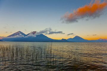
Atitlán, Toliman, and San Pedro volcanoes (Photo: Tom Pfeiffer)

Early morning at the shore of Lake Atitlán with Atitlán, Toliman and San Pedro volcanoes in the background (Photo: Tom Pfeiffer)

Sunrise over Lake Atitlán with Atitlán and Toliman volcanoes in the background (Photo: Tom Pfeiffer)

Atitlán and Toliman volcanoes seen from the shore of the Atitlán Lake (Photo: Tom Pfeiffer)
Latest satellite images