


Kilauea Volcán
Kilauea is the youngest and most active Hawaiian shield volcano, located on the southern part of the Island of Hawai'i, known as Big Island. Hawai'i is the southernmost and largest of the island chain, which owes its existence to the very active Hawaiian hot spot.
Kilauea volcano is near-constantly erupting from vents either on its summit (caldera) or on the rift zones. At present, Kilauea volcano is still having one of the most long-lived eruptions known on earth, which started in 1983 on the eastern rift zone and has mainly been concentrated at the Pu'u 'O'o vent.
Erupciones del volcán Kilauea: Near-continuous eruptions. Since 1960: 1961 (4x), 1962, 1963 (2x), 1965 (2x), 1967-68, 1968 (2x), 1969, 1969-74, 1971 (2x), 1973 (2x), 1974 (3x), 1975, 1977, 1979, 1980, 1982 (2x), 1983-2018 (incl. 1986, 1992, 1997, 2007, 2011 (3x)), 2018 (lower east rift zone in Leilani subdivision), 2020 (Dec) - 2022 (Nov), 2023 (Jan) - ongoing
Latest nearby earthquakes
| Fecha y hora | Mag / Prof. | Distancia / Ubicación | |||
|---|---|---|---|---|---|
| 20 nov 08:41 (Tiempo Universal) | 1.9 22 km | 19 km al noreste | Más | ||
| miércoles, 19 noviembre 2025 GMT (5 sismos) | |||||
| 19 nov 19:25 (Tiempo Universal) | 1.2 32 km | 21 km al suroeste | Más | ||
| 19 nov 06:29 (GMT -10) | 1.8 1.1 km | 23 km al oeste | Más | ||
| 19 nov 16:28 (Tiempo Universal) | 1.0 6.2 km | 18 km al oeste | Más | ||
| 19 nov 03:41 (Tiempo Universal) | 1.7 31 km | 21 km al suroeste | Más | ||
| 18 nov 14:57 (GMT -10) | 1.6 31 km | 26 km al sur | Más | ||
| martes, 18 noviembre 2025 GMT (1 sismo) | |||||
| 18 nov 23:13 (Tiempo Universal) | 1.4 8.9 km | 22 km al oeste | Más | ||
| lunes, 17 noviembre 2025 GMT (1 sismo) | |||||
| 17 nov 12:48 (Tiempo Universal) | 2.1 8 km | 22 km al este | Más | ||
| viernes, 14 noviembre 2025 GMT (1 sismo) | |||||
| 14 nov 23:56 (Tiempo Universal) | 2.1 29 km | 20 km al suroeste | Más | ||
Background
Kilauea volcano, a youthful shield volcano, sitting on the south east flank of the massive Mauna Loa shield volcano, is the youngest volcano (on land) of the Hawaiian hot spot and not only the most active volcano of Hawaii but at the same time also the world's active volcano. It has been in near-constant activity since there is oral or written history and it is having an uninterrupted eruption since 1983 (at present at the Pu'u 'O'o vent on the East rift zone).Its eruptions are prominent in Hawaiian Polynesian legends and written documentation about its activity go back to only 1820s when it started to attract interested visitor from all over the world and bacame one of volcanology's hot spots.
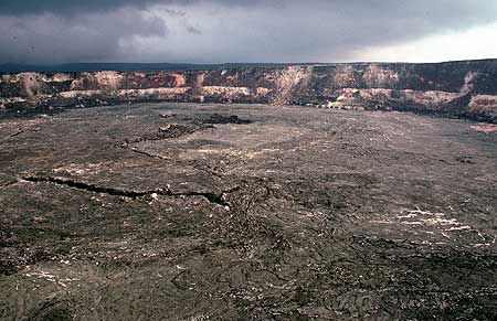
Kilauea has a large summit caldera with a central crater, Halemaumau, which is according to Hawaiian legends the home of the fire goddess Pele. Until 1924, it contained a lava lake. Kilauea has frequent summit and flank lava flow eruptions that are occurring along two elongated rift zones to the south-west and to the east, which extend to the sea on both sides of the volcano. The 3 x 5 km caldera was formed in several stages about 1500 years ago. About 90% of the surface of the basaltic shield volcano is formed of lava flows less than about 1100 years old; 70% of the volcano's surface is younger than 600 years. The long-term eruption from the East rift zone that began in 1983 has produced lava flows covering more than 100 sq km, destroying nearly 200 houses and adding new coastline to the island.
Kilauea Volcano Photos


Erupciones volcánicas significativas: Kilauea volcano
There is one uncertain or discredited eruption in 1928 from Kilauea volcano.
| Fecha | Nota | VEI | Fallecidos | Daños | ||
|---|---|---|---|---|---|---|
| Halema'uma'u Crater Obs. históricas/documentos | ? | desconocido | Información | |||
| Napau Crater Obs. históricas/documentos | ? | desconocido | ||||
| Southwest Rift Zone Obs. históricas/documentos | ? | desconocido | ||||
| Halema`uma`u Crater. Obs. históricas/documentos | 0 | desconocido | ||||
Obs. históricas/documentos | 0 | desconocido | ||||
| East rift zone (Puu O'o), Halemaumau Obs. históricas/documentos | 3 | desconocido | Información | |||
| 2018 jul 16 (erupción | Obs. históricas/documentos | 0 | ligero | Información | ||
| 2018 abr 28 (erupción | Tsunami registrado Obs. históricas/documentos | 1 | muy pesado | Información | ||
| 2018 feb 1 (erupción | Obs. históricas/documentos | 1 | 1 | desconocido | Información | |
| 2014 nov 10 (erupción | Obs. históricas/documentos | 0 | pesado | Información | ||
| 2012 mar 2 (erupción | Obs. históricas/documentos | 0 | ligero | Información | ||
| 2012 feb 10 (erupción | Obs. históricas/documentos | 0 | moderado | Información | ||
| 2009 nov 30 (erupción | Obs. históricas/documentos | 0 | moderado | Información | ||
| 2000 nov 3 (erupción | Obs. históricas/documentos | 0 | 2 | desconocido | Información | |
| 1998 abr 28 (erupción | Obs. históricas/documentos | 0 | 1 | desconocido | ||
| 1994 jul 8 (erupción | Tsunami registrado Obs. históricas/documentos | 3 | desconocido | Información | ||
| 1993 abr 19 (erupción | Obs. históricas/documentos | 0 | 1 | desconocido | Información | |
| Kilauea Caldera (SSE of Halemaumau) Obs. históricas/documentos | 0 | desconocido | ||||
| Kilauea Caldera (NE of Halemaumau) Obs. históricas/documentos | 0 | desconocido | ||||
| East rift zone (near Mauna Ulu) Obs. históricas/documentos | 0 | desconocido | ||||
| East rift zone (Pauahi Crater) Obs. históricas/documentos | 0 | desconocido | ||||
| East rift zone (near Kalalua Crater) Obs. históricas/documentos | 0 | desconocido | ||||
| Kilauea Caldera, Halemaumau Obs. históricas/documentos | 0 | desconocido | ||||
| Tsunami registrado Obs. históricas/documentos | 0 | 2 | moderado | Información | ||
| Southwest Rift Zone (1,095 m) Obs. históricas/documentos | 0 | desconocido | ||||
| Kilauea Caldera (Halemaumau and to SW) Obs. históricas/documentos | 0 | desconocido | ||||
| East rift zone (885-945 m), Alae Crater Obs. históricas/documentos | 0 | desconocido | ||||
| Kilauea Caldera, Keanakakoi Obs. históricas/documentos | 0 | desconocido | ||||
| East rift zone (Mauna Ulu, 960 m) Obs. históricas/documentos | 0 | desconocido | ||||
| East rift zone, Pauahi Obs. históricas/documentos | 0 | desconocido | ||||
| East rift zone, Pauahi, Hiiaka Obs. históricas/documentos | 0 | desconocido | ||||
| Halemaumau and upper SW rift zone Obs. históricas/documentos | 0 | desconocido | ||||
| Kilauea Caldera Obs. históricas/documentos | 0 | desconocido | ||||
| East rift zone (730-915 m) Obs. históricas/documentos | 0 | desconocido | ||||
| Halemaumau Obs. históricas/documentos | 0 | desconocido | ||||
| East rift zone (580-885 m) Obs. históricas/documentos | 0 | desconocido | ||||
| East rift zone (915-960 m) Obs. históricas/documentos | 0 | desconocido | ||||
| East rift zone (700-915 m) Obs. históricas/documentos | 0 | desconocido | ||||
| East rift zone (700-840 m) Obs. históricas/documentos | 0 | desconocido | ||||
| East rift zone (825-960 m) Obs. históricas/documentos | 0 | desconocido | ||||
| East rift zone (945-990 m) Obs. históricas/documentos | 0 | desconocido | ||||
| East rift zone (395-790 m) Obs. históricas/documentos | 1 | desconocido | ||||
| Halemaumau Obs. históricas/documentos | 1 | desconocido | ||||
| Halemaumau Obs. históricas/documentos | 1 | desconocido | ||||
| Halemaumau Obs. históricas/documentos | 1 | desconocido | ||||
| Kilauea Iki Obs. históricas/documentos | 2 | desconocido | ||||
| Kilauea Iki Obs. históricas/documentos | 2 | desconocido | ||||
| Lower east rift zone (50-400 m) Obs. históricas/documentos | ? | desconocido | ||||
| Halemaumau and Kilauea caldera Obs. históricas/documentos | ? | desconocido | ||||
| Halemaumau Obs. históricas/documentos | ? | desconocido | ||||
| Halemaumau Obs. históricas/documentos | ? | desconocido | ||||
| Halemaumau Obs. históricas/documentos | ? | desconocido | ||||
| Halemaumau Obs. históricas/documentos | ? | desconocido | ||||
| Halemaumau Obs. históricas/documentos | ? | desconocido | ||||
| Halemaumau Obs. históricas/documentos | ? | desconocido | ||||
Erupción desacreditada | ||||||
| Halemaumau Obs. históricas/documentos | ? | desconocido | ||||
| Halemaumau Obs. históricas/documentos | 0 | desconocido | ||||
| Halemaumau Obs. históricas/documentos | 2 | desconocido | ||||
| 1924 may 10 (erupción | Obs. históricas/documentos | 2 | 1 | desconocido | Información | |
| Halemaumau Obs. históricas/documentos | ? | desconocido | ||||
| East rift zone (915 m) Obs. históricas/documentos | 0 | desconocido | ||||
| East rift zone, Makaopuhi, Napau Obs. históricas/documentos | 0 | desconocido | ||||
| Kilauea Caldera Obs. históricas/documentos | 0 | desconocido | ||||
| SW rift zone (Mauna Iki, 915 m) Obs. históricas/documentos | 0 | desconocido | ||||
| Kilauea Caldera Obs. históricas/documentos | 0 | desconocido | ||||
| Kilauea Caldera Obs. históricas/documentos | 0 | desconocido | ||||
| Halemaumau Obs. históricas/documentos | ? | desconocido | ||||
| Halemaumau Obs. históricas/documentos | ? | desconocido | ||||
| Halemaumau Obs. históricas/documentos | ? | desconocido | ||||
| Halemaumau Obs. históricas/documentos | ? | desconocido | ||||
Kilauea Volcano FAQ
+When was the last eruption of Kilauea volcano?
The last confirmed eruption of Kilauea began in 2024 and is continuing (as of November 2025).
+How often does Kilauea volcano erupt?
Kilauea volcano erupts almost every year. Since its first historically documented eruption 1750, Kilauea has often been near-continuously active. The Global Volcanism Project counts 70 historic eruptions until now, spanning a total of 170 out of 275 years. In other words, Kilauea is active roughly every one in 1.6 years on average. This value is likely an underestimate, because the known history of eruption might not contain all eruptions, especially further back in time. The last eruption of Kilauea began in 2024 and is continuing (as of November 2025).
+How active is Kilauea volcano at present?
Kilauea volcano is extremely active: Since 1900, it has been near-continuously active, showing eruptive activity during 93 years out of 126 as of now. The latest eruption is still continuing at present.
+When was the largest eruption of Kilauea volcano?
The largest eruption of Kilauea volcano in historic times occurred in 1790. It ranks as a sub-plinian eruption with a magnitude 4 on the VEI (Volcanic Explosivity Index) scale.
Últimas imágenes satelitales
Kilauea Volcán Mapas


