Contact | RSS | EN | DE | EL | ES | FR | IT | RU

Volcanes en Turquía (25)

Acigöl-Nevsehir | Akyarlar | Ararat | Arpacay | Ceyhan-Osmaniye | Erciyes Dagi | Etrusk | Girekol | Gölcük | Göllü Dağ | Hasan Dagi | Karaca Dağ | Karadağ | Karapinar | Karasu Rift | Kargapazari Dagi | Kars | Kenger | Kisir Dagi | Koruhüyüğü | Kula | Nemrut Dagi | Sandal | Süphan Dağ | Tendürek Dağ
[menor] [más grande]

Volcano list

Acigöl-Nevsehir

(caldera, lava domes 1689 m)
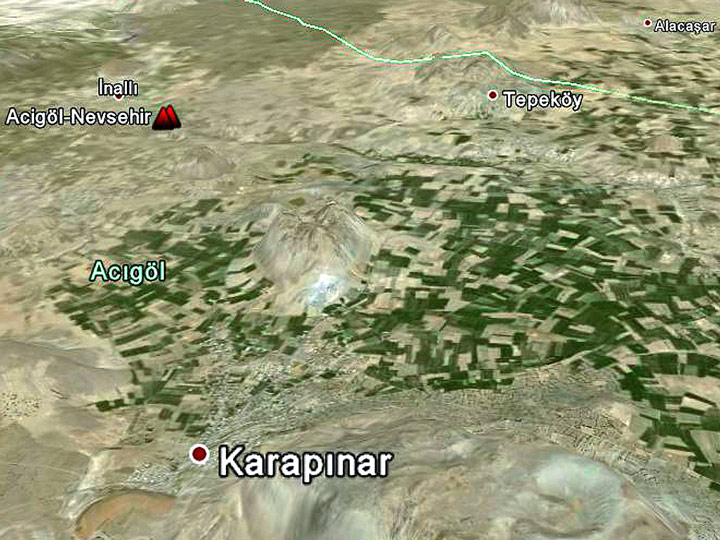
Google Earth View image of the caldera of Acigöl-Nevsehir
The big caldera of Acigöl-Nevsehir is located in central Turkey and has a size of 7-8 km diameter. [más info]

Akyarlar

(lava domes 172 m)
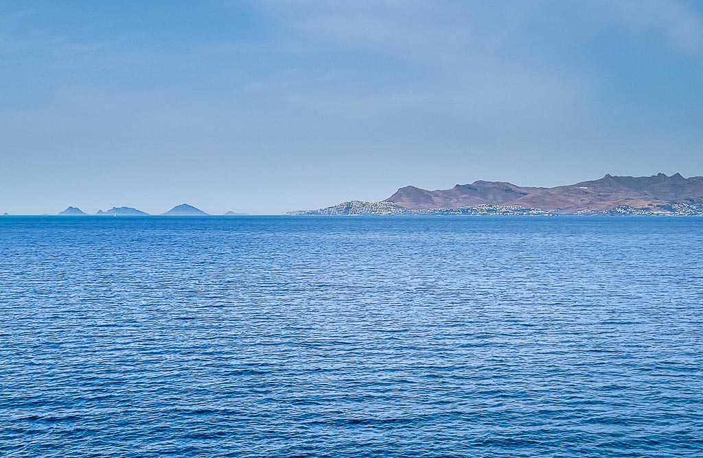
Volcanic cones and domes of Akyarlar volcanic field on the Bodrum peninsula of southwestern Turkey seen from Kos Island, Greece.
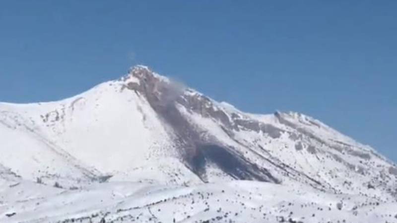
The Bodrum & Akyarlar volcanics belong to the area of the active Cos volcanic complex and are the most western volcanics of Turkey. [más info]

Ararat

(stratovolcano 5165 m)
The 5165-m-high, double-peaked stratovolcano Mount Ararat, also known as Agri Dagi, is Turkey's highest, largest volume, and easternmost volcano. [más info]

Arpacay

(Volcanic field unknown)
[más info]

Ceyhan-Osmaniye

(Volcanic field 424 m / 1391 ft)
[más info]

Erciyes Dagi

(stratovolcano 3916 m)
Erciyes Dağ or Erciyes Dagi volcano is a massive, eroded stratovolcano that dominates the northern end of the Sultansazligi Basin in central Anatolia. It covers an area of about 1300 sq km. [más info]

Etrusk

(Stratovolcano 3100 m / 10171 ft)
[más info]

Girekol

(stratovolcano 2323 m)
A huge volcano north of Van lake with a great eruption crater towards south-east. [más info]

Gölcük

(Caldera unknown)
[más info]

Göllü Dağ

(stratovolcano 2143 m)
Göllü Dağ, a 2143-m-high rhyolitic-to-rhyodacitic lava dome complex in central Anatolia, lies between the Hasan Dağ and Acigöl-Nevsehir volcanic complexes. [más info]

Hasan Dagi

(stratovolcano 3253 m)
The Hasan Dagi is a huge stratovolcano on which caldera collapses took place in ca. 7500-7600 years ago. [más info]

Karaca Dağ

(shieldvolcano 1957 m)
The huge Karaca Dağ volcano is a 1957 m high basaltic shield volcano in SE-Turkey near the Syrian border. It is situated on the Arabian foreland and about 150 km of the boundary of the Anatolian plate. It has been active since the Pliocene and also in historic times eruptions occ... [más info]

Karadağ

(stratovolcano, lava domes 2265 m)
A huge volcanic complex near the village Madenşehri with a huge crater. [más info]

Karapinar

(cinder cones, maar 1086 m)
The Karapinar volcanic field is one of the most interesting areas in south-western Turkey. [más info]

Karasu Rift

(Volcanic field 486 m / 1594 ft)
[más info]

Kargapazari Dagi

(Unknown 2089 m / 6854 ft)
[más info]

Kars

(stratovolcano ca. 3000 m)
The Kars Plateau is a broad calc-alkaline to alkaline volcanic field of largely Pliocene to mid-Pleistocene age in the NE corner of Turkey (Innocenti et al., 1982; Yilmaz, 1990). [más info]

Kenger

(cinder cone 745 m)
The Kenger volcano belongs to the fault system that created also the Kula cinder cones in western Turkey. [más info]

Kisir Dagi

(Unknown 3192 m / 10472 ft)
[más info]

Koruhüyüğü

(cinder cones 433 m)
A serial of cinder cones in the "graben" structure in the area north of Kirikhan town in Turkey. [más info]

Kula

(cinder cones, maars 740 m)
The Kula volcanic field in western Turkey near the city Selendi had the last eruptions probably more than 10.000 years ago. [más info]

Nemrut Dagi

(caldera 2948 m)
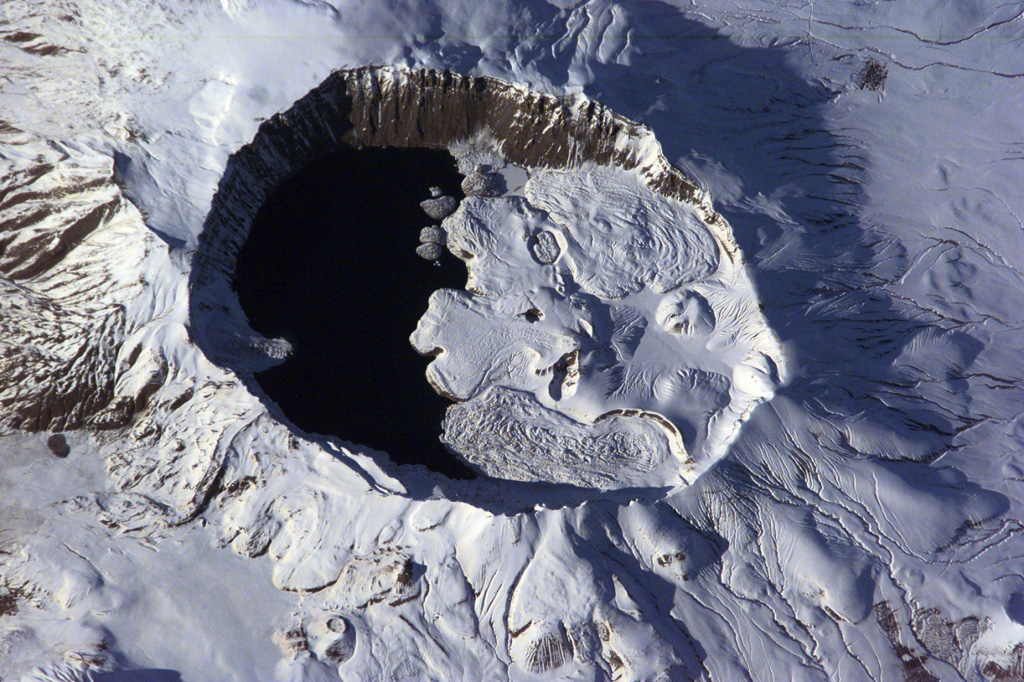
The summit of Nemrut Dagi is truncated by a 5 x 9 km caldera near Lake Van in eastern Turkey. A lake that partially fills the western side of the caldera is constrained by post-caldera eruptions that produced glassy obsidian lava flows from domes on the eastern caldera floor. A series of scoria cones and lava domes were erupted along N-S-trending fissures on the northern flank. Ash layers in Lake Van document numerous Holocene eruptions from Nemrut Dagi. (Image: NASA International Space Station image ISS001-E-6354, 2001, http://eol.jsc.nasa.gov/).
Nemrut Dağ (or Nemrut Dagi) volcano is the westernmost of a group of volcanoes near Lake Van in eastern Anatolia, and the only one that has erupted in historical time. It contains a 9 x 5 km caldera partially filled on its western side by a caldera lake. [más info]

Sandal

(cinder cone 855 m)
The Sandal volcano belongs to the Kula volcanic area. [más info]

Süphan Dağ

(lava dome, strato volcano, pyroclatsic flows 4158 m)
The huge lava dome and strato-volcano is situated north of the famous lake Van. [más info]

Tendürek Dağ

(stratovolcano 3584 m)
Tendürek Dağ, also written as Tendürük Dagi, is an elongated shield volcano that rises 1800 m above the plain of Dogubayazit, near the Iranian border, south of Mount Ararat. [más info]

Noticias

jue, 1 ene 1970, 00:00

Erupción volcánica reportada de la montaña Göksun Kuşkayası, Turquía, 11 de febrero de 2023

Erupción volcánica reportada de la montaña Göksun Kuşkayası, Turquía, 11 de febrero de 2023
Se está difundiendo en Turquía la noticia de que un nuevo volcán podría haberse formado en una montaña llamada Kuşyakası, cerca de la aldea de Büyükkızılcık en el distrito de Göksun en la provincia de Kahramanmaraş, el 11 de febrero de 2023. ... Read all
Why is there advertising on this site?
Sources: VolcanoDiscovery / VolcanoAdventures and other sources as noted.
Use of material: Most text and images on our websites are owned by us. Re-use is generally not permitted without authorization. Contact us for licensing rights.
Volcanoes & Earthquakes
VolcanoDiscovery Home
Volcanes | Sismos | Fotos | News | App
Adventure & Study Travel
Tours to Volcanoes and Volcanic Areas: walking tours, photo tours, study tours
Tours & Dates | FAQ | About us
Get our newsletter!
Company info
Contact | Legal info | Terms & conditions
Follow us
Follow us on facebook Follow us on Instagram Follow us on Twitter Visit our Youtube channel
EN | DE | EL | ES | FR | IT | RU
VolcanoDiscovery GmbH, Germany, Reg. nr.: HRB 103744, EU Tax Id: DE 297 465 123 owned and created by
Dr. Tom Pfeiffer, volcanologist, volcano photographer, tour organizer member of
IAVCEI
IAVCEI
Vulkanologische Gesellschaft
Volcanological Society
Ecotourism Greece
Ecotourism Greece
RUV insurance
Insured by R+V
VolcanoDiscovery © 2004- All Rights Reserved | Privacy - Cookie Settings
Cookie-free, privacy-friendly web stats