| Date | Volcano | VEI | Region | Deaths | Damage | |
|---|---|---|---|---|---|---|
| Tendürek Dağ | ? | Turkey | ||||
| Ararat Upper northern flank | 3? | Turkey | ||||
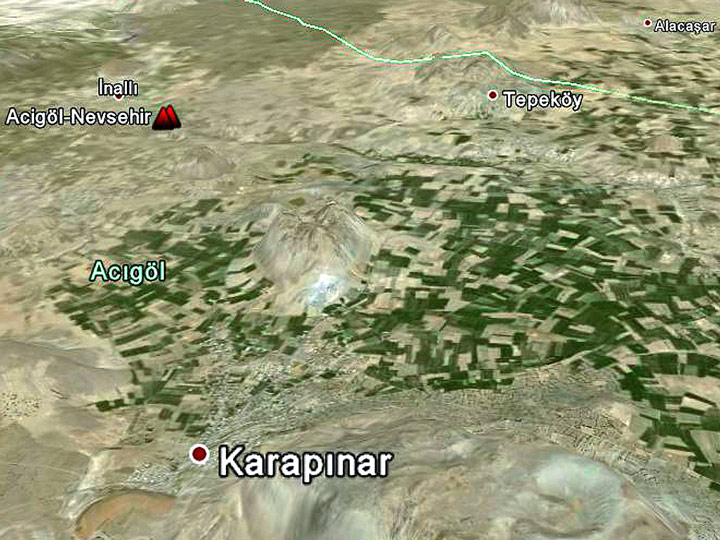
| Nemrut Dagi East flank (Lake Van) | ? | Turkey | ||||
| Nemrut Dagi | ? | Turkey | ||||
| Nemrut Dagi North flank (Nemrut Boynu) | ? | Turkey | ||||
| Nemrut Dagi East flank (Lake Van) | ? | Turkey | ||||
The last volcanic eruption in Turkey was from Tendürek Dağ volcano in 1855.
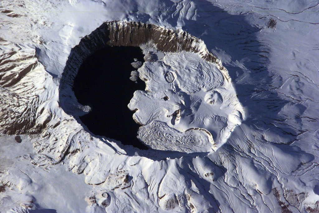
The first historically documented eruption occurred around 1111 AD from Nemrut Dagi volcano.
Since 1111 AD, Turkey has seen at least 6 historically documented eruptions. This means that a volcano erupts on average every 152 years.
The largest eruption in Turkey in historic times was from Ararat volcano. It occurred in 1840. It ranks as a "vulcanian" eruption with a magnitude 3 on the VEI (Volcanic Explosivity Index) scale.
| Date and Time | Mag / Depth | Nearest Volcano / Location | |||
|---|---|---|---|---|---|
| May 24, 01:52 pm (Istanbul) | 3.7 9.9 km | 148 km (92 mi) W of | Aegean Sea, 13 km north of Uzunada Island, Izmir, Turkey I FELT IT - 2 reports | Info | |
| Tuesday, May 20, 2025 GMT (1 quake) | |||||
| May 20, 11:36 pm (Istanbul) | 4.0 8.2 km | 244 km (152 mi) N of | Sea of Marmara, 28 km southwest of Beylikduzu, Istanbul, Turkey I FELT IT - 64 reports | Info | |
| Monday, May 19, 2025 GMT (1 quake) | |||||
| May 19, 03:58 pm (Istanbul) | 3.8 8.8 km | 104 km (65 mi) N of | 24 km west of Aydin, Aydin, Turkey I FELT IT - 7 reports | Info | |
| Sunday, May 18, 2025 GMT (2 quakes) | |||||
| May 18, 10:29 am (Athens) | 3.8 14 km | 99 km (62 mi) SE of | 37 km south of Rhodes, Dodecanese, South Aegean, Greece I FELT IT - 61 reports | Info | |
| May 18, 04:53 am (Istanbul) | 3.7 7 km | 59 km (37 mi) E of | Aegean Sea, 44 km southwest of Mugla, Mugla, Turkey I FELT IT - 2 reports | Info | |
| Saturday, May 17, 2025 GMT (1 quake) | |||||
| May 17, 10:05 pm (Istanbul) | 4.0 7 km | 110 km (68 mi) E of | 16 km northeast of Goksun, Kahramanmaras, Turkey I FELT IT - 2 reports | Info | |
| Date | Mag | Region | Deaths | Damage | |
|---|---|---|---|---|---|
| 2023 Feb 6 | 7.8 | Kahramanmaras; Syria | 56,697 | catastrophic | Info |
| 1999 Nov 12 | 7.2 | Bolu-duzce-kaynasli, Adapazari, Zonguldak | 894 | catastrophic | Info |
| 1999 Aug 17 | 7.6 | Istanbul, Kocaeli, Sakarya | 17,118 | catastrophic | Info |
| 1992 Mar 13 | 6.9 | Erzincan | 653 | very heavy | Info |
| 1983 Oct 30 | 6.9 | Erzurum, Kars, Khorasan, Pasinler, Narman | 1,342 | heavy | Info |
| 1976 Nov 24 | 7.0 | Muradiye | 5,000 | heavy | Info |
| 1975 Sep 6 | 6.7 | Lice | 2,311 | heavy | Info |
| 1971 May 22 | 6.7 | Bingol | 1,000 | moderate | Info |
| 1970 Mar 28 | 7.2 | Gediz | 1,086 | heavy | Info |
| 1966 Aug 19 | 6.8 | Varto | 2,394 | heavy | Info |
| 1953 Mar 18 | 7.3 | Yenice, Onon | 1,070 | moderate | Info |
| 1946 May 31 | 5.9 | Ustukran | 840 | moderate | Info |
| 1944 Feb 1 | 7.6 | Turkey | 2,381 | heavy | Info |
| 1943 Nov 26 | 7.5 | Ladik, Samsun, Havza | 4,020 | very heavy | Info |
| 1942 Dec 20 | 7.0 | Niksar, Erbaa | 1,000 | very heavy | Info |
| 1939 Dec 26 | 7.8 | Erzincan | 32,700 | heavy | Info |
| 1914 Oct 3 | 7.0 | Burdur, Kilinc, Keciborlu, Isparta | 4,000 | very heavy | Info |
| 1912 Aug 9 | 7.2 | Marmara Sea | 2,800 | very heavy | Info |
| 1903 May 28 | 5.8 | Varginis, Cardahli, Mehkerek | 1,000 | heavy | Info |
| 1903 Apr 28 | 6.3 | Malazgirt | 3,560 | very heavy | Info |
The deadliest earthquake in Turkey since 1900 was the magnitude 7.8 earthquake in ![]() Turkey, Gaziantep on Feb, 6, 2023. It resulted in 56,697 fatalities and 119,200 injured people. A tsunami was generated by the quake as well and contributed to its desctuctive effects. This was the 6th worst quake in Turkey during recorded history.
Turkey, Gaziantep on Feb, 6, 2023. It resulted in 56,697 fatalities and 119,200 injured people. A tsunami was generated by the quake as well and contributed to its desctuctive effects. This was the 6th worst quake in Turkey during recorded history.
Since 1900, at least 117 earthquakes claimed an estimated total of 150,000 fatalities in Turkey.
There were 152 damaging or deadly quakes during this period that caused economic losses of approx. $70 billion US Dollars combined.