Contact | RSS | EN | DE | EL | ES | FR | IT | RU

Volcans en Tanzanie (23)

Burko | Embagai | Gelai | Hanang | Igwisi Hills | Izumbwe-Mpoli | Katete | Kerimasi | Ketumbeine | Kilimanjaro | Kwaraha | Kyejo | Loolmalasin | Meru | Ngorongoro | Ngozi | Ol Doinyo Lengai | Olmoti | Rungwe | Sadiman | SW Usangu Basin | Tukuyu | Usangu Scarp Basalt
[plus petit] [plus gros]

Volcano list

Burko

(Stratovolcano 2136 m / 7008 ft)
[plus d'info]

Embagai

(Caldera 3220 m / 10564 ft)
Embagai (also spelled Empakai) is an extinct volcano in the Tanzanian Rift valley near the famous Ngorongoro crater.
Its caldera is surrounded by steep, forested cliffs approx. 300 m high and contains a beautiful crater lake home to thousands of flamingos and other birds. [plus d'info]

Gelai

(Shield 2942 m / 9652 ft)
[plus d'info]

Hanang

(Stratovolcano 3418 m / 11214 ft)
[plus d'info]

Igwisi Hills

(Tuff cones unknown summit elevation)
[plus d'info]

Izumbwe-Mpoli

(Pyroclastic cones 1568 m / 5,144 ft)
[plus d'info]

Katete

(Stratovolcano 2481 m / 8140 ft)
[plus d'info]

Kerimasi

(Stratovolcano 2600 m / 8530 ft)
[plus d'info]

Ketumbeine

(Shield 2942 m / 9652 ft)
[plus d'info]

Kilimanjaro

(Stratovolcano 5895 m (19,340 ft))
Massive Kilimanjaro, Africa's highest mountain, consists of three large stratovolcanoes constructed along a NW-SE trend. [plus d'info]

Kwaraha

(Stratovolcano 2415 m / 7923 ft)
[plus d'info]

Kyejo

(Stratovolcano 2175 m / 7,136 ft)
[plus d'info]

Loolmalasin

(Unknown 3627 m / 11900 ft)
[plus d'info]

Meru

(Stratovolcano 4565 m / 14,977 ft)
[plus d'info]

Ngorongoro

(Caldera 2376 m / 7795 ft)
[plus d'info]

Ngozi

(Caldera 2622 m / 8,602 ft)
[plus d'info]

Ol Doinyo Lengai

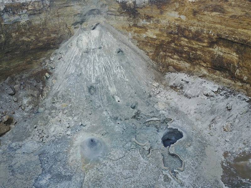
(Stratovolcano 2890 m )
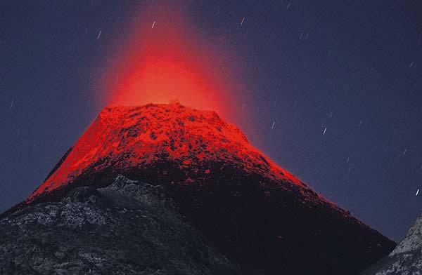
Erupting hornito at Lengai volcano
Ol Doinyo Lengai, a symmetrical, steep classical stratovolcano rises majestically about 2000m from the East Africal Rift Valley depression to a summit elevation of 2890 m. To the Maassai people, it is home of God, which is also the meaning of the name. Ol Doinyo Lengai is the onl... [plus d'info]

Olmoti

(Caldera 3099 m / 10167 ft)
[plus d'info]

Rungwe

(Stratovolcano 2956 m / 9,698 ft)
[plus d'info]

Sadiman

(Stratovolcano 2865 m / 9400 ft)
[plus d'info]

SW Usangu Basin

(Lava domes 2179 m / 7,149 ft)
[plus d'info]

Tukuyu

(Shield 1541 m / 5056 ft)
[plus d'info]

Usangu Scarp Basalt

(Pyroclastic cone 1690 m / 5545 ft)
[plus d'info]
Actualités
jeu., 7 déc. 2017, 12:12

Ol Doinyo Lengai volcano (Tanzania): active crater and natrocarbonatite lava in early Dec 2017

Ol Doinyo Lengai volcano (Tanzania): active crater and natrocarbonatite lava in early Dec 2017
The volcano continues to slowly erupt natrocarbonatite lava inside the deep pit crater of the 2007-08 cinder cone which occupies the active northern crater of Lengai volcano. We present a selection of aerial photos taken a few days ago by our friend Gian Schachenmann. ... Read all
lun., 21 sept. 2015, 18:17

Meru volcano (Tanzania): false eruption report - plume caused by forest fire

The volcano is NOT erupting. The reported eruption turned out to be a false report - what seemed to be an ash plume was in fact caused by a huge forest fire on the slopes of Meru. ... Read all
Découvrez notre app gratuite !
Volcanoes & Earthquakes - new app for Android
Android | Version iOS

Plus sur VolcanoDiscovery

Why is there advertising on this site?

Support us - Help us upgrade our services!

We truly love working to bring you the latest volcano and earthquake data from around the world. Maintaining our website and our free apps does require, however, considerable time and resources.
We need financing to increase hard- and software capacity as well as support our editor team. We're aiming to achieve uninterrupted service wherever an earthquake or volcano eruption unfolds, and your donations can make it happen! Every donation will be highly appreciated. If you find the information useful and would like to support our team in integrating further features, write great content, and in upgrading our soft- and hardware, please make a donation (PayPal or Online credit card payment).

Planned features:Thanks to your past donations, these features have been added recently:
Download and Upgrade the Volcanoes & Earthquakes app to get one of the fastest seismic and volcano alerts online:
Android | IOS
Thank you!
Copyright: VolcanoDiscovery ou autres sources indiquées.
Utilisation des documents: Les textes, les images et les vidéos de ce site internet sont protégées par copyright. Toute reproduction et tout usage sans accord préalable ne sont pas autorisés. Si vous désirez acquérir pour certains documents (photos, vidéos, textes ou autres) le droit de reproduction, d'édition et, plus généralement, de toute utilisation destinée à un usage public, qu'elle soit commerciale ou pas, vous êtes priés de nous contacter.
Volcanoes & Earthquakes
VolcanoDiscovery Home
Volcans | Séismes | Photos | Actualités | App
Adventure & Study Travel
Tours to Volcanoes and Volcanic Areas: walking tours, photo tours, study tours
Voyages |
Get our newsletter!
Company info
Contact | Mentions légales | Terms & conditions
Follow us
Follow us on facebook Follow us on Instagram Follow us on Twitter Visit our Youtube channel
EN | DE | EL | ES | FR | IT | RU
VolcanoDiscovery GmbH, Germany, Reg. nr.: HRB 103744, EU Tax Id: DE 297 465 123 owned and created by
Dr. Tom Pfeiffer, volcanologist, volcano photographer, tour organizer member of
IAVCEI
IAVCEI
Vulkanologische Gesellschaft
Volcanological Society
Ecotourism Greece
Ecotourism Greece
RUV insurance
Insured by R+V
VolcanoDiscovery © 2004- All Rights Reserved | Privacy - Changer Préférences