Contact | RSS | EN | DE | EL | ES | FR | IT | RU

Trident Volcano

Updated: 27 avril. 2024 17:31 GMT -
Stratovolcano 1864 m / 6,115 ft
United States, Alaska Peninsula, 58.24°N / -155.1°W
Condition actuelle: normal / en sommeil (1 sur 5)
Last update: 11 janv. 2024 (alert level diminished to Green)

[smaller] [larger]
Style éruptif tipique: unspecified
Eruptions du volcan Trident: 1974 

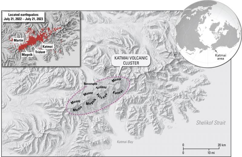
Derniers séismes proches

HeureMag. / ProfondeurDistance / Lieu
25 avril 22:36 (Anchorage)
0.9

102 km
65 km N of Karluk, Alaska
Info
mercredi, 24 avril 2024 GMT (1 séisme)
24 avril 01:38 (Anchorage)
0.8

35 km
83 km NNW of Karluk, Alaska
Info
mardi, 23 avril 2024 GMT (1 séisme)
23 avril 03:27 (Anchorage)
0.9

98 km
156 km à l'ouest de Kodiak, Kodiak Island, Alaska, États-Unis
Info
jeudi, 18 avril 2024 GMT (1 séisme)
18 avril 13:04 (Anchorage)
1.1

1.1 km
3.6 km à l'ouest 85 km NNW of Karluk, Alaska
Info
mercredi, 17 avril 2024 GMT (1 séisme)
17 avril 01:18 (Anchorage)
1.0

5.5 km
Lake and Peninsula, 171 km à l'ouest de Kodiak, Kodiak Island, Alaska, États-Unis
Info
dimanche, 14 avril 2024 GMT (1 séisme)
14 avril 10:30 (Anchorage)
0.8

1.1 km
91 km N of Karluk, Alaska
Info

Introduction

The Trident stratovolcano cluster was named for the three prominent peaks that were the most visible features at the summit prior to 1953. The andesitic-dacitic Trident group consists of four overlapping stratovolcanoes and numerous flank lava domes, including Falling Mountain and Mt. Cerberus on the far west flank. The summit complex of Trident is located 3-5 km SE of Novarupta volcano, and merges along a ridge to the NE with Katmai volcano. The three oldest Trident volcanoes are glaciated and Pleistocene in age, while the youngest, Southwest Trident, was formed during historical time. Eruptions at the Trident complex migrated stepwise with time from the NE to the SW. In 1953 a new lava dome began growing on the SW flank of Trident I volcano. A series of thick andesitic lava flows were erupted between 1953 and 1968, forming a cone with 400-800 m of local relief. Periodic explosions took place until 1974, and the current summit contains a 350-m-wide crater. Some of the distal lava flows from West Trident stratovolcano collapsed into the Novarupta vent during its 1912 eruption.
---
Smithsonian / GVP volcano information

Latest satellite images

trident satellite image sat1trident satellite image sat2
Actualités
jeu., 11 janv. 2024, 07:35

Trident volcano (Alaska Peninsula): alert level diminished to Green

The activity of the volcano has waned over the past month. ... Read all
mer., 26 juil. 2023, 08:46

Trident volcano (Alaska Peninsula): seismic swarm continues, uplift has reached 5 cm, likelihood of eruption increases

Katmai volcanic cluster (image: AVO)
The Alaska Volcano Observatory (AVO) reported that a significant increase in low-frequency earthquakes (both shallow and deep-level earthquakes) started to develop in the region of Katmai volcanic cluster since May this year. ... Read all

Sur cette page:

Découvrez notre app gratuite !
Volcanoes & Earthquakes - new app for Android
Android | Version iOS

Plus sur VolcanoDiscovery

Why is there advertising on this site?

Support us - Help us upgrade our services!

We truly love working to bring you the latest volcano and earthquake data from around the world. Maintaining our website and our free apps does require, however, considerable time and resources.
We need financing to increase hard- and software capacity as well as support our editor team. We're aiming to achieve uninterrupted service wherever an earthquake or volcano eruption unfolds, and your donations can make it happen! Every donation will be highly appreciated. If you find the information useful and would like to support our team in integrating further features, write great content, and in upgrading our soft- and hardware, please make a donation (PayPal or Online credit card payment).

Planned features:Thanks to your past donations, these features have been added recently:
Download and Upgrade the Volcanoes & Earthquakes app to get one of the fastest seismic and volcano alerts online:
Android | IOS
Thank you!
Copyright: VolcanoDiscovery ou autres sources indiquées.
Utilisation des documents: Les textes, les images et les vidéos de ce site internet sont protégées par copyright. Toute reproduction et tout usage sans accord préalable ne sont pas autorisés. Si vous désirez acquérir pour certains documents (photos, vidéos, textes ou autres) le droit de reproduction, d'édition et, plus généralement, de toute utilisation destinée à un usage public, qu'elle soit commerciale ou pas, vous êtes priés de nous contacter.
Volcanoes & Earthquakes
VolcanoDiscovery Home
Volcans | Séismes | Photos | Actualités | App
Adventure & Study Travel
Tours to Volcanoes and Volcanic Areas: walking tours, photo tours, study tours
Voyages |
Get our newsletter!
Company info
Contact | Mentions légales | Terms & conditions
Follow us
Follow us on facebook Follow us on Instagram Follow us on Twitter Visit our Youtube channel
EN | DE | EL | ES | FR | IT | RU
VolcanoDiscovery GmbH, Germany, Reg. nr.: HRB 103744, EU Tax Id: DE 297 465 123 owned and created by
Dr. Tom Pfeiffer, volcanologist, volcano photographer, tour organizer member of
IAVCEI
IAVCEI
Vulkanologische Gesellschaft
Volcanological Society
Ecotourism Greece
Ecotourism Greece
RUV insurance
Insured by R+V
VolcanoDiscovery © 2004- All Rights Reserved | Privacy - Changer Préférences