Karapinar Volcano
Updated: 28 apr. 2024 11:48 GMT -
cinder cones, maar 1086 m
Turchia, 37.69°N / 33.64°E
Current status: normal or dormant (1 out of 5)
Turchia, 37.69°N / 33.64°E
Current status: normal or dormant (1 out of 5)
The Karapinar volcanic field is one of the most interesting areas in south-western Turkey.
[smaller] [larger]
Eruzioni del vulcano Karapinar: unknown, but probably in the last 3000-6000 years ago
Latest nearby earthquakes
| Data / ora | Mag. / Prof. | Distanza / Ubicazione | |||
| 24 apr 01:26 (Istanbul) | 1.1 7 km | 19 km a nord | Info | ||
| mercoledì, 17 aprile 2024 GMT (2 sismi) | |||||
| 17 apr 16:09 (Istanbul) | 1.5 5.8 km | 27 km a nord est | Info | ||
| 17 apr 15:31 (Istanbul) | 1.7 7 km | 25 km a nord est | Info | ||
Background
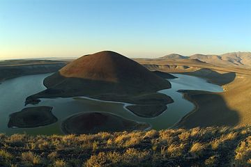
In the area of Karapinar there are about five cinder cones, two lava flows, and several explosion craters and one maar. It is not too far from the huge Karacadag stratovolcano complex. The 300-m-high Meke Dagi is one of the largest cinder cones in Central Anatolia. The explosion craters and maars are located along a SW-NE line consistent with the elongation of Karacadag volcano. The maars evolved from hyaloclastite tuff rings to maars to cinder cones, reflecting varying lake water levels during the eruption. The last eruptions probably took place in the last 3000-6000 years ago.Karapinar Volcano Photos
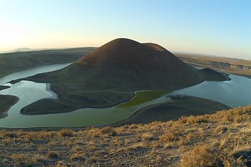
Lago vulcanico Meke Golu ("Lago Profumato") visto da SE (campo vulcanico Karapinar, Turchia) (Photo: marcofulle)
Cono di cenere di Meke Golu (campo del vulcano Karapinar, Turchia) visto da SW. Subito dietro il cono di cenere, a destra, il maar di Aci Gol, a circa 5 km. (Photo: marco...
Latest satellite images