| Ημερομηνία | Ηφαίστειο | VEI | Περιοχή | Θάνατοι | Ζημιά | |
|---|---|---|---|---|---|---|
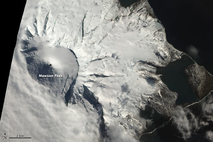
| Heard Mawson Peak | 0 | Australia, Southern Indian Ocean | άγνωστο | |||
| Heard Mawson Peak | 0 | Australia, Southern Indian Ocean | άγνωστο | |||
| McDonald Islands | 0 | Australia, Southern Indian Ocean | άγνωστο | |||
| Heard Mawson Peak | 0 | Australia, Southern Indian Ocean | άγνωστο | |||
| McDonald Islands | 1? | Australia, Southern Indian Ocean | άγνωστο | |||
| Heard Mawson Peak and upper south flank | 2 | Australia, Southern Indian Ocean | άγνωστο | |||
| McDonald Islands Northern part of McDonald Island | 1? | Australia, Southern Indian Ocean | άγνωστο | |||
| Heard Mawson Peak | 2? | Australia, Southern Indian Ocean | άγνωστο | |||
| McDonald Islands Submarine vent near McDonald Islands | 0 | Australia, Southern Indian Ocean | άγνωστο | |||
| Heard Mawson Peak | 0 | Australia, Southern Indian Ocean | άγνωστο | |||
| Heard Mawson Peak | 2? | Australia, Southern Indian Ocean | άγνωστο | |||
| Heard Mawson Peak | 2 | Australia, Southern Indian Ocean | άγνωστο | |||
| Heard Mawson Peak | 2 | Australia, Southern Indian Ocean | άγνωστο | |||
| Heard Mawson Peak | 2 | Australia, Southern Indian Ocean | άγνωστο | |||
| Heard Mawson Peak | 2 | Australia, Southern Indian Ocean | άγνωστο | |||
The last volcanic eruption στη Αυστραλία was from Heard volcano. It began in 2012 and is continuing (as of May 2025).
The first historically documented eruption occurred 1910 from Heard volcano.
Since 1910, Αυστραλία has seen at least 15 historically documented eruptions. This means that a volcano erupts on average every 7.7 years.
Αυστραλία is volcanically relatively active: Since 1900, at least 2 volcanoes στη Αυστραλία have been active.Since 1900, Αυστραλία has had 15 volcanic eruptions from 2 individual volcanoes. Volcanic eruptions have been recorded erupted during 35 years out of 126 as of now. This means, at least one volcano στη Αυστραλία has been in eruption in one in 3.6 years on average. The latest eruption from Heard volcano volcano is still continuing at present.
The largest eruption στη Αυστραλία in historic times was from Heard volcano. It occurred during 2000 - 2001. It ranks as a strombolian to vulcanian eruption with a magnitude 2 on the VEI (Volcanic Explosivity Index) scale.
| Ημερομην. κ. ώρα | Mag / Βάθος | Πλησιέστερο ηφαίστειο / Τοποθεσία | |||
|---|---|---|---|---|---|
| 2025-04-30 20:06 | 2.6 10 km | 818 km ΒΔ από | 8.5 km βορειοανατολικά από Blinman, Australia Meridional, Αυστραλία I FELT IT | Περ. | |
| 30 Απρ 16:52 (GMT +9:30) | 3.6 10 km | 1247 km Ν από | 94 km νοτιοανατολικά από Kalkarindji, Victoria Daly, Βόρεια Επικράτεια, Αυστραλία I FELT IT | Περ. | |
| Τρίτη, 29 Απριλίου 2025 GMT (2 σεισμοί) | |||||
| 30 Απρ 04:56 (GMT +10) | 5.0 10 km | 1397 km Β από | Macquarie Island Region I FELT IT | Περ. | |
| 30 Απρ 00:53 (GMT +10) | 6.8 10 km | 1404 km Β από | Macquarie Island, Southern Ocean I FELT IT - 3 reports | Περ. | |
| Δευτέρα, 28 Απριλίου 2025 GMT (1 σεισμός) | |||||
| 28 Απρ 18:34 (GMT +8) | 2.9 10 km | 1682 km Ν από | Indian Ocean, 40 km νοτιοδυτικά από Coral Bay, Carnarvon, Δυτική Αυστραλία, Αυστραλία I FELT IT | Περ. | |
| Κυριακή, 27 Απριλίου 2025 GMT (1 σεισμός) | |||||
| 2025-04-28 02:44 | 2.7 5 km | 667 km ΒΑ από | 3.1 km νοτιοδυτικά από Boorowa, Hilltops, Νέα Νότια Ουαλία, Αυστραλία I FELT IT - 3 reports | Περ. | |
| Ημερομηνία | Mag | Περιοχή | Θάνατοι | Ζημιά | |
|---|---|---|---|---|---|
| 2021 Sep 21 | 5.9 | Melbourne | 0 | μέτριο | Info |
| 2014 Feb 26 | 4.5 | Kalgoorlie | 0 | ελαφρύ | Info |
| 2010 Apr 20 | 5.2 | Kalgoorlie | 0 | ελαφρύ | Info |
| 2009 Sep 22 | 3.1 | Mornington | 0 | ελαφρύ | Info |
| 1989 Dec 27 | 5.4 | Newcastle | 12 | καταστροφικό | Info |
| 1989 May 23 | 8.2 | Macquarie Island: Macquarie Station; New Zealand | 0 | ελαφρύ | Info |
| 1988 Jan 22 | 6.7 | Tennant Creek | 0 | μέτριο | Info |
| 1988 Jan 22 | 6.3 | Tennant Creek | 0 | μέτριο | Info |
| 1979 Jun 2 | 6.1 | Western | 0 | ελαφρύ | Info |
| 1973 Mar 9 | 5.5 | Wollongong, Sydney | 0 | μάλλον καμία ζημιά | Info |
| 1968 Oct 14 | 6.9 | Meckering, Northam, Cunderdin, York | 0 | ελαφρύ | Info |
| 1954 Feb 28 | 5.4 | Adelaide S | 0 | μέτριο | Info |
Ο πιο θανατηφόρος σεισμός στη Αυστραλία από το 1900 ήταν the magnitude 5.4 earthquake στη ![]() Αυστραλία, Επικράτεια Αυστραλιανής Πρωτεύουσας on Δεκ, 27, 1989. Είχε ως αποτέλεσμα 12 θανάτους και ###DEADLIEST-JURED### τραυματίες. Αυτός ήταν ο πιο καταστροφικός σεισμός στη Αυστραλία που έχει καταγραφεί ποτέ.
Αυστραλία, Επικράτεια Αυστραλιανής Πρωτεύουσας on Δεκ, 27, 1989. Είχε ως αποτέλεσμα 12 θανάτους και ###DEADLIEST-JURED### τραυματίες. Αυτός ήταν ο πιο καταστροφικός σεισμός στη Αυστραλία που έχει καταγραφεί ποτέ.
Από το 1900, τουλάχιστον 1 σεισμοί έχουν υπολογίσει συνολικά ###TOTALFAT ### θανατηφόρα στη Αυστραλία.
Υπήρξαν 12 ζημιογόνες ή θανατηφόρους σεισμούς κατά τη διάρκεια αυτής της περιόδου που έχουν προκαλέσει οικονομικές απώλειες περίπου. $1 δισεκατομμύρια δολάρια ΗΠΑ συνδυαστικά.