Emi Koussi Volcán
Updated: 27 mayo 2025 17:57 GMT -
Pyroclastic shield
Chad, 19.8°N / 18.53°E 
+Hora local:
Salida del sol:
Puesta del sol:
Salida de la luna:
Puesta de la luna:
Summit height: 3415 m / 11,204 ft
Current status: normal or dormant (1 out of 5)
[smaller] [larger]
Erupciones del volcán Emi Koussi: unknown, no recent eruptions
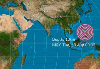
Latest nearby earthquakes
| Fecha y hora | Mag / Prof. | Distancia / Ubicación | |||
|---|---|---|---|---|---|
Background
The large volcano of Emi Koussi at the SE end of the Tibesti Range forms the highest summit of the Sahara. The 60 x 80 km massif was constructed over a basement of Cretaceous and Paleozoic sandstones. Two nested calderas, 12 x 15 km in size, truncate the dominantly trachytic volcano, whose 3415 m high point lies on the southern caldera rim of the low-angle pyroclastic shield volcano. The calderas contain several explosion craters, lava domes, and young scoria cones, along with lava flows of recent and pre-modern age (Geze et al., 1959). The spectacular Era Kohor (Trou au Natron du Koussi) caldera on the SE floor of the 2nd caldera is 2-3 km wide and 350 m deep. The latest activity in the calderas produced three maars, and numerous basaltic cinder cones and associated lava flows have been constructed both within the calderas and on their outer flanks. The Yi-Yerra thermal area is located on the southern flank.---
Smithsonian / GVP volcano information
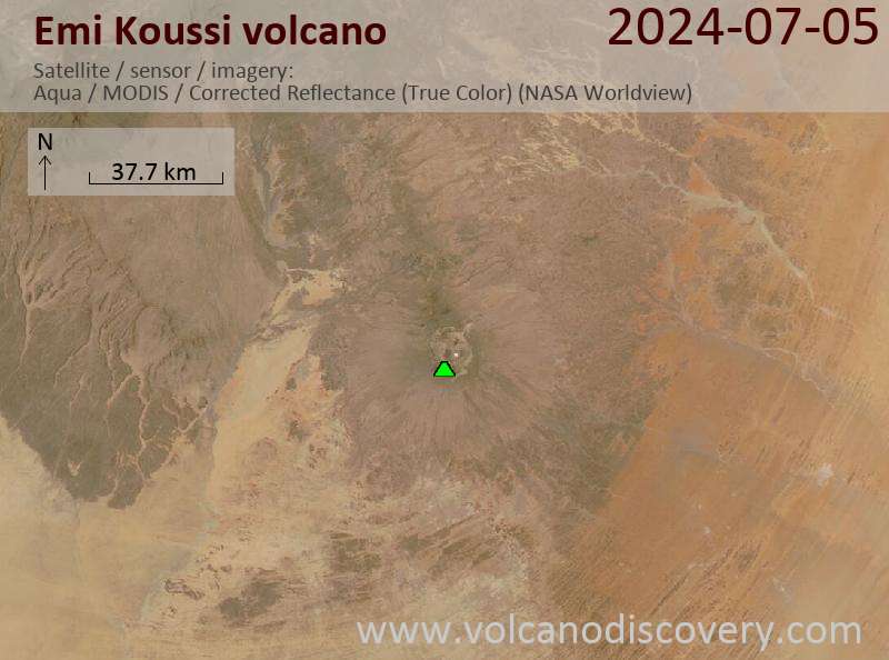
Últimas imágenes satelitales
Emi Koussi Volcán Mapas
Below is a selection of maps showing the location and surroundings of the volcano at various resolutions based on aerial-imagery / terrain maps. Feel free to use them for non-commercial purposes on your blog or website as long as you credit them with a link back to this page (click to copy it).

Satellite/aerial-type map of Emi Koussi volcano (world scale)

Terrain-type map of Emi Koussi volcano (world scale)

Satellite/aerial-type map of Emi Koussi volcano (region scale large)

Terrain-type map of Emi Koussi volcano (region scale large)

Satellite/aerial-type map of Emi Koussi volcano (region scale medium)

Terrain-type map of Emi Koussi volcano (region scale medium)

Satellite/aerial-type map of Emi Koussi volcano (region scale small)

Terrain-type map of Emi Koussi volcano (region scale small)

Satellite/aerial-type map of Emi Koussi volcano (local scale large)

Terrain-type map of Emi Koussi volcano (local scale large)

Satellite/aerial-type map of Emi Koussi volcano (local scale medium)

Terrain-type map of Emi Koussi volcano (local scale medium)

Satellite/aerial-type map of Emi Koussi volcano (local scale small)

Terrain-type map of Emi Koussi volcano (local scale small)

Satellite/aerial-type map of Emi Koussi volcano (scale of 10s of km)

Terrain-type map of Emi Koussi volcano (scale of 10s of km)

Satellite/aerial-type map of Emi Koussi volcano (scale of 20-40 km)

Terrain-type map of Emi Koussi volcano (scale of 20-40 km)

Satellite/aerial-type map of Emi Koussi volcano (scale of approx. 10-20 km)

Terrain-type map of Emi Koussi volcano (scale of approx. 10-20 km)

Satellite/aerial-type map of Emi Koussi volcano (scale of 5-10 km)

Satellite/aerial-type map of Emi Koussi volcano (scale of few kilometers)