


St. Michael Volcano
Updated: 4 мая 2024 13:30 GMT -
Shield volcanoes 715 m / 2,346 ft
United States, Western Alaska, 63.45°N / -162.12°W
Current status: normal or dormant (1 out of 5)
United States, Western Alaska, 63.45°N / -162.12°W
Current status: normal or dormant (1 out of 5)
[smaller] [larger]
St. Michael volcano eruptions: unknown, no recent eruptions
Latest nearby earthquakes
| Время | Магнитуда / Глубина | Расстояние / Местоположение | |||
Background
The St. Michael volcanic field, at the south end of Norton Sound, covers all of St. Michael and Stuart Islands with more than 55 cones and craters. Broad low shield volcanoes underlie the younger cones, and maar volcanoes are located at the SW part of the volcanic field, which covers >3000 sq km and extends inland along the Golsovia and Kogok rivers. The youngest activity is of Holocene age, and native tradition says that a village was submerged by lava three times.---
Smithsonian / GVP volcano information
St. Michael Volcano Photos
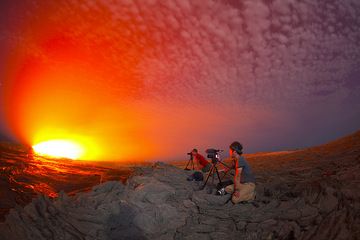
Два члена нашей группы, Мишель из Бельгии и кинорежиссер Майкл из Канады, наблюдают, фотографируют и снимают лавовое озеро. Сцена, снятая в (Photo: Tom Pfeiffer)...
Майкл снимает извержения ночью. (Photo: Tom Pfeiffer)
Режиссер Майкл работает над нашим предстоящим документальным фильмом. (Photo: Tom Pfeiffer)
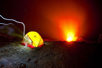
Палатка Михаила расположена на кратере действующего вулкана Эрта Але с извергающимся лавовым озером в центре кратера. Свет человека с фон (Photo: Tom Pfeiffer)...
Latest satellite images


