Kontakt | RSS | EN | DE | EL | ES | FR | IT | RU

Vulkane in den Marianeninseln und Guam (26)

Agrigan | Ahyi | Alamagan | Anatahan | Asuncion | East Diamante | Eifuku | Esmeralda Bank | Farallon de Pajaros | Forecast Seamount | Guguan | Kasuga 1 | Kasuga 3 | Mariana Back-Arc Segment at 15.5°N | Maug Islands | NW Rota-1 | Pagan | Ruby | Sarigan | Seamount X | South Sarigan Seamount | Supply Reef | Tracey Seamount | Unnamed 20.30°N/143.20°E | Unnamed 21.00°N/142.90°E | Zealandia Bank
[kleiner] [größer]

Volcano list

Agrigan

(Stratovolcano 965 m / 3,166 ft)
Agrigan volcano is an active stratovolcano and the highest of the volcanoes in the Marianas volcanic arc. It contains contains a 500-m-deep, flat-floored caldera. The last confirmed eruption was in 1917. [mehr Infos]

Ahyi

(Submarine volcano -137 m / - 449 ft)
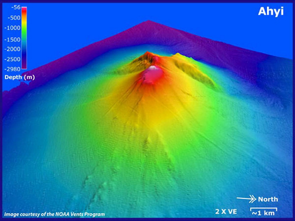
3D model of Ahyi seamount volcano (image via GVP)
[mehr Infos]

Alamagan

(Stratovolcano 744 m / 2,441 ft)
[mehr Infos]

Anatahan

(stratovolcano 790 m / 2,592 ft)
Anatahan volcano forms the small 9 x 3.7 E-W elongated Anatahan Island in the northern Marianas, about 120 km north of Saipan, the regional Commonwealth of the Northern Mariana Islands capital.
The volcano is at the southern end of the 1500 km long chain of volcanoes forme... [mehr Infos]

Asuncion

(Stratovolcano 857 m / 2,812 ft)
[mehr Infos]

East Diamante

(Submarine volcano -127 m / - 417 ft)
[mehr Infos]

Eifuku

(Submarine -551 m / -1808 ft)
[mehr Infos]

Esmeralda Bank

(Submarine volcano -43 m / - 141 ft)
[mehr Infos]

Farallon de Pajaros

(Stratovolcano 360 m / 1,181 ft)
[mehr Infos]

Forecast Seamount

(Submarine volcano unknown summit elevation)
[mehr Infos]

Guguan

(Stratovolcano 287 m / 942 ft)
[mehr Infos]

Kasuga 1

(Submarine -598 m / -1962 ft)
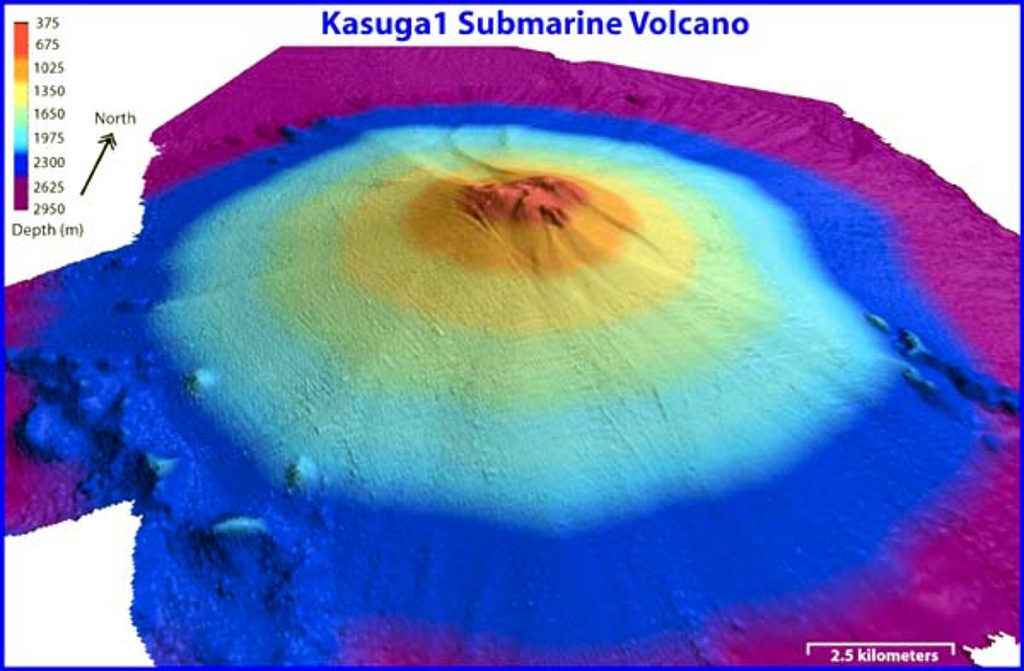
Kasuga 1 is the northernmost of three seamounts in the Kasuga seamount chain. It rises to within about 600 m of the sea surface. Pumice from a submarine eruption was witnessed in 1959. (Image: NOAA, 2003, http://oceanexplorer.noaa.gov/explorations/03fire/logs/mar02/media/kasuga.html)
The Kasuga 1 seamount is a conical volcano that rises to within 598 m of the sea surface SE of Fukujin submarine volcano. It was listed as an active volcano by the Japan Meteorological Agency, and floating pumice attributed to a submarine eruption was seen south of the volcano in... [mehr Infos]

Kasuga 3

(Submarine -1325 m / -4347 ft)
[mehr Infos]

Mariana Back-Arc Segment at 15.5°N

(submarine volcano -4100 m / -13,451 ft)
Approx. 130 km west of Saipan lies a volcanically active submarine spreading zone at water depths of more than 4,000 meters. Evidence of significant volcanic activity from this area has been found recently. [mehr Infos]

Maug Islands

(Stratovolcano 227 m / 745 ft)
[mehr Infos]

NW Rota-1

(Submarine volcano -517 m / - 1,696 ft)
[mehr Infos]

Pagan

(stratovolcanoes 570 m / 1,870 ft)
Pagan volcano consists of 2 stratovolcanoes (North and South Pagan) connected by a narrow isthmus and forms the largest and one of the most active of the Mariana Islands. It is located 173 nautical miles north of Saipan.
Nearly all historical eruptions of Pagan, which were... [mehr Infos]

Ruby

(Submarine volcano -230 m / - 755 ft)
[mehr Infos]

Sarigan

(Stratovolcano 538 m / 1,765 ft)
[mehr Infos]

Seamount X

(Submarine volcano -1230 m / - 4,035 ft)
[mehr Infos]

South Sarigan Seamount

(Submarine volcano -184 m / - 604 ft)
[mehr Infos]

Supply Reef

(Submarine volcano -8 m / - 26 ft)
[mehr Infos]

Tracey Seamount

(Submarine -900 m / -2953 ft)
[mehr Infos]

Unnamed 20.30°N/143.20°E

(Submarine volcano? unknown summit elevation)
[mehr Infos]

Unnamed 21.00°N/142.90°E

(Submarine volcano? unknown summit elevation)
[mehr Infos]

Zealandia Bank

(Stratovolcano 0 m / 0 ft)
[mehr Infos]
Latest news:
Mi, 10. Apr 2024, 14:00

Ahyi volcano (Mariana Islands, USA) - Smithsonian / USGS Weekly Volcanic Activity Report for 3 April-9 April 2024 (Continuing Activity)

Signs of unrest at Ahyi Seamount had not been observed in satellite images since 27 March when an area of discolored water was present near the seamount. Both the Aviation Color Code and the Volcano Alert Level were lowered to Unassigned at 0346 on 10 April due to the absence of activity and the lack of local monitoring stations. ... Read all
Mi, 10. Apr 2024, 02:38

Ahyi undersea volcano (Mariana Islands): alert status lowered to Unassigned

Since 27 March this year, no signs of unrest have been observed at Ahyi Seamount. ... Read all
Mi, 3. Apr 2024, 18:00

Ahyi volcano (Mariana Islands, USA) - Smithsonian / USGS Weekly Volcanic Activity Report for 27 March-2 April 2024 (Continuing Activity)

Signs of unrest at Ahyi Seamount continued. Small (less than 2 km long) plumes of discolored seawater in the vicinity of the seamount were observed in satellite images during 22 and 24-26 March. The Aviation Color Code remained at Yellow (the second lowest level on a four-color scale) and the Volcano Alert Level remained at Advisory (the second lowest level on a four-level scale). ... Read all
Mi, 13. Mär 2024, 15:00

Ahyi volcano (Mariana Islands, USA) - Smithsonian / USGS Weekly Volcanic Activity Report for 6 March-12 March 2024 (New Activity / Unrest)

Signs of unrest at Ahyi Seamount continued. A small plume of discolored seawater in the vicinity of the seamount was observed in a 5 March satellite image. The Aviation Color Code remained at Yellow (the second lowest level on a four-color scale) and the Volcano Alert Level remained at Advisory (the second lowest level on a four-level scale). ... Read all
Do, 7. Mär 2024, 11:00

Ahyi volcano (Mariana Islands, USA) - Smithsonian / USGS Weekly Volcanic Activity Report for 6 March-12 March 2024 (New Activity / Unrest)

Signs of unrest at Ahyi Seamount continued. A small plume of discolored seawater in the vicinity of the seamount was observed in a 5 March satellite image. The Aviation Color Code remained at Yellow (the second lowest level on a four-color scale) and the Volcano Alert Level remained at Advisory (the second lowest level on a four-level scale). ... Read all
App herunterladen
Volcanoes & Earthquakes - new app for Android
Android | iOS-Version

Mehr auf VolcanoDiscovery

Warum gibt es Werbung auf dieser Seite?

Unterstützen Sie unsere Arbeit!

Diese Webseite und die dazugehörigen Apps und Tools instandzuhalten und kostenlos Nachrichten zu Vulkanen, Erdbeben und anderen Themen bereitzustellen, verschlingt enorm viel Zeit und auch Geld.
Wenn Sie die Infos mögen und uns in der Arbeit dazu unterstützen wollen, würden wir uns über eine Spende (über PayPal oder mit Kreditkarte) sehr freuen.
Online Zahlung (Kreditkarte)
Damit können wir Ihnen auch in Zukunft neue Features entwickeln und Bestehende laufend verbessern.Vielen Dank!
Sources: VolcanoDiscovery / VolcanoAdventures and other sources as noted.
Use of material: Most text and images on our websites are owned by us. Re-use is generally not permitted without authorization. Contact us for licensing rights.
Volcanoes & Earthquakes
VolcanoDiscovery Home
Vulkane | Erdbeben | Fotos | News | App
Adventure & Study Travel
Reisen zu Vulkanen und Vulkangebieten: Wanderreisen, Studienreisen, Fotoreisen
Tours & Dates | FAQ | About us
Get our newsletter!
Company info
Kontakt | Impressum | AGB
Follow us
Follow us on facebook Follow us on Instagram Follow us on Twitter Visit our Youtube channel
EN | DE | EL | ES | FR | IT | RU
VolcanoDiscovery GmbH, Germany, Reg. nr.: HRB 103744, EU Tax Id: DE 297 465 123 owned and created by
Dr. Tom Pfeiffer, volcanologist, volcano photographer, tour organizer member of
IAVCEI
IAVCEI
Vulkanologische Gesellschaft
Volcanological Society
Ecotourism Greece
Ecotourism Greece
RUV insurance
Insured by R+V
VolcanoDiscovery © 2004- All Rights Reserved | Datenschutz - Cookie Einstellungen