| RSS | EN | DE | EL | ES | FR | IT | RU

Nishino-shima Volcano

Updated: Nov 8, 2025 22:00 GMT -
caldera, submarine volcano
Volcano Islands, Japan, 27.27°N / 140.88°E
Summit height: approx 70 m / 215 ft (currently growing)
Current status: minor activity or eruption warning (3 out of 5)
Last update: 6 Nov 2024 (new aerial images)
Nishi-no-shima on 18 Oct 2015 (Japanese Coast Guard)

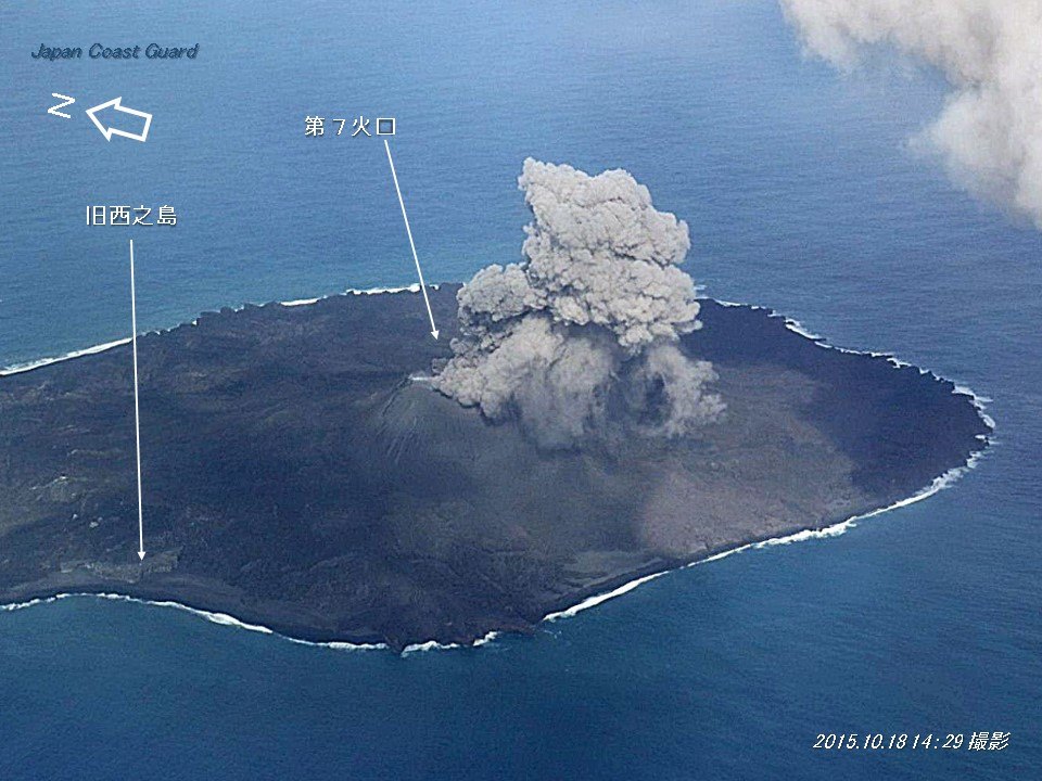
Nishinoshima volcano (西之島, Nishi-no-shima meaning literally: Western Island, also: Rosario Island) is the tiny submerged part of a caldera in the northern Volcano Islands of Japan. The small 700 m wide island was significantly enlarged during the last eruption in 1974, which joined several new islands that formed then.
Water discoloration due to possible minor eruptions and / or shallow submarine hydrothermal activity in the area is a frequent sight.
The mostly submerged volcano is a massive seamount with prominent flank cones on the south, west and NE flanks. The southern cone rises to a depth of 214 m below the sea surface, 9 km SSE of Nishinoshima.

[smaller] [larger]
Typical eruption style: explosive
Nishino-shima volcano eruptions: 2019-ongoing, 2017, 2013-15, 1985(?), 1982(?), 1980(?), 1978(?), 1975(?), 1973-74

Latest nearby earthquakes

Date and TimeMag / DepthDistance / Location

Significant volcanic eruptions: Nishino-shima volcano

In the past 10,000 years, Nishino-shima has had at least 7 confirmed eruptions, all documented by historical records or observations.
Additionally, there are 8 uncertain or discredited eruptions from Nishino-shima volcano.
The table below lists all known eruptions (date in bold face) of Nishino-shima volcano in historic times and during the past 10,000 years. Updates on the most recent volcanic activity of Nishino-shima can be found on the news page of Nishino-shima volcano.
DateNoteVEIDeathsDamage
2022 Oct 1 - 2023 Oct 13Central cone of 2013 island
Historical obs./docs.
2
2021 Aug 14 - Aug 15Central cone of 2013 island
Historical obs./docs.
2
2019 Dec 5 - 2020 Aug 27Central cone of 2013 island
Historical obs./docs.
1
2018 Jul 12 - Jul 21Central cone of 2013 island
Historical obs./docs.
1
2017 Apr 18 ±1 d. - Aug 17 ±6 d.Central cone of 2013 island
Historical obs./docs.
2
2013 Nov 20 - 2015 Nov 17 ?Vent SSE of existing Nishinoshima
Historical obs./docs.
2
?? 2001 Jan 16 ±15 d.
Uncertain Eruption
0
?? 1986 Jul 2 ±182 d. - 1990 Jul 2 ±182 d.
Uncertain Eruption
0
?? 1985 Dec 2
Uncertain Eruption
0
?? 1983 Jul 2 ±182 d. - 1984 Jul 2 ±182 d.
Uncertain Eruption
0
?? 1982 Apr 16 ±15 d.
Uncertain Eruption
0
?? 1980 Jul 7 - 1981 ?
Uncertain Eruption
0
?? 1978 Nov 16 - 1979 ?
Uncertain Eruption
0
?? 1975 Jul 2 ±182 d. - 1977 Jul 2 ±182 d.
Uncertain Eruption
0
1973 Apr 12 - 1974 May 5 ±4 d.Vent SE of existing Nishinoshima
Historical obs./docs.
2
Remark:
Our list of volcanic eruptions closely follows the database of eruptions of the Smithsonian's Global Volcanism Project (GVP), the internationally most recognized data source for volcanic eruptions, but also includes significant eruptive episodes or related volcano events. "Volcanic eruptions" are usually to be understood as sequences of individual eruptive episodes that can follow each other, or even overlap (if several vents are involved), and can last many years, decades or even longer. For example, the current activity of Stromboli volcano is understood as a single eruption that has been ongoing since 1934.
Sources: NOAA National Centers for Environmental Information (NCEI), Global Significant Volcanic Eruptions Database. doi:10.7289/V5TD9V7K | Global Volcanism Project / Smithsonian Institution

Nishino-shima Volcano FAQ

+When was the last eruption of Nishino-shima volcano?

+How often does Nishino-shima volcano erupt?

+How active is Nishino-shima volcano at present?

+When was the largest eruption of Nishino-shima volcano?

Latest satellite images

Nishinoshima satellite image sat1Nishinoshima satellite image sat2

Nishino-shima Volcano Maps

Below is a selection of maps showing the location and surroundings of the volcano at various resolutions based on aerial-imagery / terrain maps. Feel free to use them for non-commercial purposes on your blog or website as long as you credit them with a link back to this page (click to copy it).
Satellite/aerial-type map of Nishino-shima volcano (world scale)
Terrain-type map of Nishino-shima volcano (world scale)
Satellite/aerial-type map of Nishino-shima volcano (region scale large)
Terrain-type map of Nishino-shima volcano (region scale large)
Satellite/aerial-type map of Nishino-shima volcano (region scale medium)
Terrain-type map of Nishino-shima volcano (region scale medium)
Satellite/aerial-type map of Nishino-shima volcano (region scale small)
Terrain-type map of Nishino-shima volcano (region scale small)
Satellite/aerial-type map of Nishino-shima volcano (local scale large)
Terrain-type map of Nishino-shima volcano (local scale large)
Satellite/aerial-type map of Nishino-shima volcano (local scale medium)
Terrain-type map of Nishino-shima volcano (local scale medium)
Satellite/aerial-type map of Nishino-shima volcano (local scale small)
Terrain-type map of Nishino-shima volcano (local scale small)
Satellite/aerial-type map of Nishino-shima volcano (scale of 10s of km)
Terrain-type map of Nishino-shima volcano (scale of 10s of km)
Satellite/aerial-type map of Nishino-shima volcano (scale of 20-40 km)
Terrain-type map of Nishino-shima volcano (scale of 20-40 km)
Satellite/aerial-type map of Nishino-shima volcano (scale of approx. 10-20 km)
Terrain-type map of Nishino-shima volcano (scale of approx. 10-20 km)
Satellite/aerial-type map of Nishino-shima volcano (scale of 5-10 km)
Satellite/aerial-type map of Nishino-shima volcano (scale of few kilometers)
Volcanoes & Earthquakes - new app for Android
Guaranteed tours
20 Nov - 3 Dec 2025: Desert, salt and volcanoes - Danakil desert (Ethiopia)
2-10 May 2026: From Stromboli to Etna - Sicily and Eolian Islands (Italy)
= spaces available   = guaranteed   = few spaces left   = booked out
Wed, 6 Nov 2024, 06:18

Nishinoshima volcano (Pacific Ocean, Japan): new aerial images

The flank of Nishinoshima captured on 23 October (image: JCG)
The Japan Coast Guard (JCG) released a new series of images of the volcano from a reconnaissance flight on 23 October. ... Read all
Wed, 7 Aug 2024, 02:39

Nishinoshima volcano (Pacific Ocean, Japan): new images confirm ongoing discolored water around edifice

The discolored water in the vicinity of Nishinoshima volcano captured on 17 July (image: JCG)
The Japan Coast Guard (JCG) released a new series of images of the volcano from a reconnaissance flight on July 17. Discolored water continues to be detected in the vicinity of the volcano, likely associated with the hydrothermal system beneath the edifice. In this system, hot water and steam interact with the surrounding rocks, dissolving minerals and leading to changes in water color, such as a yellow-to-green tint due to sulfur dioxide and hydrogen sulfide. Additionally, the imagery shows a sustained small crater pond on the crater floor and white steam emissions rising from fumaroles. Read all

On this page:

Try our free app!
Volcanoes & Earthquakes - new app for Android
Android | iOS version

More on VolcanoDiscovery

Why is there advertising on this site?

Support Us – Help Us Enhance Our Services!

We’re passionate about delivering the latest volcano and earthquake data from around the globe — just for you. However, maintaining our website and free apps requires significant time, effort, and resources.
Your support helps us expand our hardware and software capabilities and empowers our dedicated editorial team. Our mission is to provide uninterrupted, real-time updates whenever an earthquake strikes or a volcano erupts — and your donations make this possible. Every contribution, big or small, is deeply appreciated. If you find our information valuable and want to help us add new features, create compelling content, and improve our technology, please consider making a donation:

Donate with PayPal:

Planned Features:

Thanks to your past donations, we have recently added:
Download the Volcanoes & Earthquakes app to stay among the first to receive the fastest seismic and volcano alerts online:
Android | iOS
Thank you for being part of our mission!
Sources: VolcanoDiscovery / VolcanoAdventures and other sources as noted.
Use of material: Most text and images on our websites are owned by us. Re-use is generally not permitted without authorization. Contact us for licensing rights.
Volcanoes & Earthquakes
VolcanoDiscovery Home
Volcanoes | Earthquakes | Photos | Volcano News | | Shop | App
Adventure & Study Travel
Tours to Volcanoes and Volcanic Areas: walking tours, photo tours, study tours
Tours & Dates | FAQ | About us
Get our newsletter!
Company info
Contact | Legal info | Terms & conditions
Follow us
Follow us on facebook Follow us on Instagram Follow us on Bluesky Follow us on Twitter Visit our Youtube channel
EN | DE | EL | ES | FR | IT | RU
VolcanoDiscovery GmbH, Germany, Reg. nr.: HRB 103744, EU Tax Id: DE 297 465 123 owned and created by
Dr. Tom Pfeiffer, volcanologist, volcano photographer, tour organizer member of
IAVCEI
IAVCEI
Vulkanologische Gesellschaft
Volcanological Society
Ecotourism Greece
Ecotourism Greece
RUV insurance
Insured by R+V
VolcanoDiscovery © 2004- All Rights Reserved | Privacy - Cookie Settings