Trident Volcano
Updated: 14 mayo 2024 10:22 GMT -
Stratovolcano 1864 m / 6,115 ft
United States, Alaska Peninsula, 58.24°N / -155.1°W
Current status: normal or dormant (1 out of 5)
United States, Alaska Peninsula, 58.24°N / -155.1°W
Current status: normal or dormant (1 out of 5)
Last update: 11 ene 2024 (alert level diminished to Green)
[smaller] [larger]
Erupciones del volcán Trident: 1974
Latest nearby earthquakes
| Fecha / Hora | Revista / Prof. | Distancia / Ubicación | |||
| 11 may 11:05 (Anchorage) | 1.0 4 km | Más | |||
| jueves, 9 mayo 2024 GMT (1 sismo) | |||||
| 9 may 05:43 (Anchorage) | 1.6 0 km | 18 km al oeste | Más | ||
| martes, 7 mayo 2024 GMT (1 sismo) | |||||
| 7 may 03:36 (Anchorage) | 1.8 100 km | 19 km al este | Más | ||
| sábado, 4 mayo 2024 GMT (1 sismo) | |||||
| 3 may 19:07 (Anchorage) | 2.4 0 km | 17 km al oeste | Más | ||
| jueves, 2 mayo 2024 GMT (2 sismos) | |||||
| 2 may 13:23 (Anchorage) | 1.1 0 km | 18 km al oeste | Más | ||
| 2 may 03:37 (Anchorage) | 0.9 2.7 km | Más | |||
Background
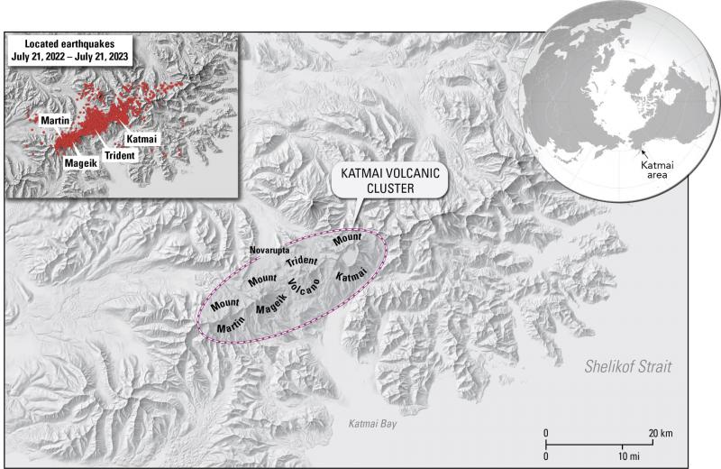
The Trident stratovolcano cluster was named for the three prominent peaks that were the most visible features at the summit prior to 1953. The andesitic-dacitic Trident group consists of four overlapping stratovolcanoes and numerous flank lava domes, including Falling Mountain and Mt. Cerberus on the far west flank. The summit complex of Trident is located 3-5 km SE of Novarupta volcano, and merges along a ridge to the NE with Katmai volcano. The three oldest Trident volcanoes are glaciated and Pleistocene in age, while the youngest, Southwest Trident, was formed during historical time. Eruptions at the Trident complex migrated stepwise with time from the NE to the SW. In 1953 a new lava dome began growing on the SW flank of Trident I volcano. A series of thick andesitic lava flows were erupted between 1953 and 1968, forming a cone with 400-800 m of local relief. Periodic explosions took place until 1974, and the current summit contains a 350-m-wide crater. Some of the distal lava flows from West Trident stratovolcano collapsed into the Novarupta vent during its 1912 eruption.---
Smithsonian / GVP volcano information


