Adatara Volcano
Updated: 27 avril. 2024 13:51 GMT -
stratovolcanoes 1718 m / 5,636 ft
Fukushima province, Japan, 37.64°N / 140.29°E
Condition actuelle: normal / en sommeil (1 sur 5)
Fukushima province, Japan, 37.64°N / 140.29°E
Condition actuelle: normal / en sommeil (1 sur 5)
Last update: 26 févr. 2022
Adatara volcano is a group of overlapping stratovolcanoes east of Bandai volcano and located 15 km SW of Fukushima City. Its highest summit is Minowa-yama stratovolcano, north of Tetsu-zan, which is the currently active stratovolcano. The group forms a N-S directed elongated chain.
The volcano is known for its hot springs and fumaroles. Io-gawa river ("Sulfur River") exits the complex to the west.
72 workers of a sulfur mine in the summit crater were killed during an eruption in 1900. Historical eruptions were all from within the 1.2-km-wide, 350-m-deep Numonotaira crater of Tetsu-zan.
[smaller] [larger]
Eruptions du volcan Adatara: 1996, 1900, 1899, 1813 (?)
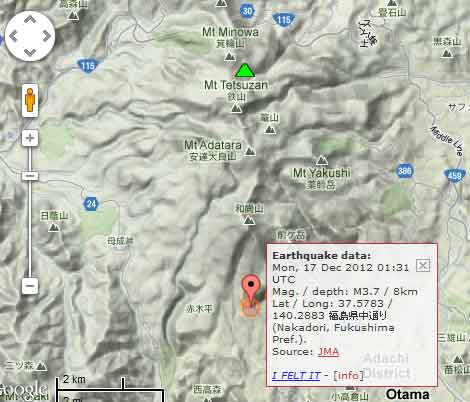
Derniers séismes proches
| Heure | Mag. / Profondeur | Distance / Lieu | |||
Introduction
The broad forested massif of Adatara volcano is mainly andesitic and consists of stratovolcanoes and lava domes built upon Tertiary sedimentary rocks on the south and rest on the flank of Azuma volcano on the north.Adatara was constructed in 3 main stages that began about 550,000, 350,000, and 200,000 years ago. In the first stage, lava flows and pyroclastic flows formed the Maegatake cone. The second stage built the Osyozan cone. The 3rd stage erupted large amounts of lava flows, pyroclastic flows and andesitic lava domes and built the present-day chain of volcanoes.
---
Source:
Yamamoto, T., & Sakaguchi, K. (2000). Eruptive history of Adatara volcano, NE Japan, during last 250,000 years based on tephrostratigraphy. Journal of Geological Society of Japan, 106(12), 865–882. GEOLOGICAL SOCIETY OF JAPAN.
Eruptions du volcan Adatara
1997 fatalities
On 15 September 1997 4 tourists were killed on Adatara volcano by inhaling lethal quantities of H2S gas, which had build up on the floor of Numano-taira crater.
The hikers were part of a group of 14 who visited Adatara volcano. 3 were killed initially and the 4th in his attempt to rescue the others. ...plus d'info
Latest satellite images