| RSS | EN | DE | EL | ES | FR | IT | RU

Volcans au Japon (546)

Japan has over 100 active volcanoes, more than almost any other country and accounts alone for about 10 % of all active volcanoes in the world. The volcanoes belong to the Pacific Ring of Fire, caused by subduction zones of the Pacific plate beneath continental and other oceanic plates along its margins.
Japan's volcanic arcs and tectonic setting
Japan is located at the junction of 4 tectonic plates - the Pacific, Philippine, Eurasian and North American plates, and its volcanoes are mainly located on 5 subduction-zone related volcanic arcs where the Pacific Plate descends under the North American Plate along the Kuril Trench and the Japan Trench and underneath the Philippine Sea Plate along the Izu-Bonin Trench. The Philippine Plate itself subducts beneath the Eurasian Plate at the western end, forming the Ryukyu Trench. The principal resulting volcanic ars are:
- Ryukyu Arc and Southwest Honshu Arcs in the south (Philippine plate subducting beneath between the Eurasian Plate),
- Izu-Bonin-Mariana Arc (subduction of Pacific plate beneath Philippine plate)
- Northeast Honshu and Kurile Arc in the north (subduction of Pacific plate beneath the N-American plate)
(more info: www.glgarcs.net/intro/subduction.html)

Besides intense volcanic activity, Japan is one of the places in the world most affected by frequent, and sometimes devastatingly large earthquakes. Its oceanic setting makes it vulnerable for tsunamis as well, as the tragedy of the 11 March 2011 8.9 earthquake and tsunami terrifyingly illustrated.

Record in historically documented eruptions
Japan's first documented historical eruption was from Aso volcano in 553 AD , the year after Buddhism was introduced from Korea. It holds a record in the number of historically documented eruptions.
Japan's largest historical eruption (Towada, 915 AD), 17 Japanese volcanoes had been documented in eruption, more than the rest of the world combined (including 10 in Europe).

[Masquer/afficher les séismes] | [plus petit] [plus gros]
+
Ata caldera | Akaigawa | Akan | Birao | Chubetsu | Daisetsu | E-san | E-san Maru-yama | Hakodate-yama | Horohoro-Tokushumbetsu | Kariba | Komaga-take | Kumaneshiri | Kutcharo | Kuttara | Mashu | Musa | Nigorigawa | Nipesotsu-Maruyama | Niseikaushuppe | Niseko | Okushiri-Katsuma-yama | Onnebetsu | Orofure-Raiba | Oshima Maru-yama | Oshima-Ko-jima | Oshima-Oshima | Raiden | Rausu | Rishiri | Samakkenupuri | Sapporo | Shari | Shiitokoro | Shikaribetsu | Shikaribetsu Group | Shikotsu | Shiretoko | Shiretoko-Iozan | Shiribetsu | Soranuma | Tenchozan | Tengu-Hirayama | Tokachi | Tokachi-Eboshi | Tokachi-Mitsumata | Tomuraushi Volcanic Group | Unabetsu | Usu | Washibetsu | Yokotsu | Yotei | Zenikame | Aoga-shima | Doyo | Hachijo-jima | Inamba-jima | Kozushima | Kurose Hole | Mikura Seamount | Mikura-jima | Miyake-shima | Mokuyo | Myojin Knoll | Myojinsho | Nii-jima | Onoharajima | Oshima | Sofugan | Suiyo | Sumisujima | To-shima | Tori-shima | Udonejima | Daikoku | Fukujin | Fukutoku-Okanoba | Getsuyo Seamount | Iwo-jima | Kaikata | Kaitoku | Kasuga | Kayo Seamount | Kinyo Seamount | Kita-Fukutokutai | Kita-Ioto | Minami Kasuga | Minami-Hiyoshi | Nichiyo Seamount | Nikko | Nishino-shima | NW Eifuku | unnamed | Abu | Adachi | Adatara | Aizu Nunobiki | Akagi | Akita-Komagatake | Akita-Yake-yama | Aonoyama | Aoso | Asakusa | Asama | Ashitaka | Ayame-daira | Azuma | Azumayasan | Bandai | Bishamon-dake | Chojagahara | Chokai | Daikon-jima | Dainichi-yama | Dainichiga-take | Daira-Komaga-take | Daisen | Daito | Daruma | Dorobu | Eboshi | Eboshi-Washigatake | Funagata | Futamata | Gankyoji | Ganto-Kamuro | Gassan | Hachimantai | Hakkoda | Hakone | Haku-san | Hanamagari | Haruna | Hijiori | Hiuchi | Hodakadake | Hotaka | Iiji | Iizuna | Iwaki | Iwate | Izu-Tobu | Jaishi | Kaminoroka | Kamitakara | Kannabe | Kanpu | Kayo | Kenashi | Kinunuma-Nenakusa | Kirigamine | Kita Yatsugatake | Kobinai | Komochi-Onoko | Kurikoma | Kurofuji | Kurohime | Kusatsu-Shirane | Kyoga-take | Madarao | Masugata | Megata | Midagahara | Minakami | Momisawa-dake | Moriyoshi | Motodori | Mt Fuji | Mukaimachi | Mutsu-Hiuchi-dake | Mutsure-jima | Myoko | Naeba | Nanashigure | Nantai | Nanzaki | Narugo | Nasu | Nekoma | Niigata-Yake-yama | Nikko-Shirane | Norikura | Noro | Numanokami | Numazawa | Nyoho-Akanagi | Nyuto-Takakura | Oetaka-yama | Ogino-Sen | Oki-Dogo | Okiura | Omanago | Omeshi-dake | Onikobe | Ontake-san | Osore-yama | Ryohaku Maru-yama | Sanbe | Sekita | Sengoku | Shiga | Shikuma | Shirataka | Shirouma-Oike | Sukai-Kesemaru | Sumon | Sunagohara | Taga | Takahara | Takamatsu | Takara | Takayashiro | Tamagawa | Tanaba | Tashiro | Tazawa | Tenshi | Tokuyama-Mitake | Tomuro | Torikabuto | Towada | Tsuruta | Ueno | Usami | Utsukushigahara | Washiba-Kumonotaira | Yake-dake | Yakeishi | Yatsugatake | Yokote | Yuga-mine | Yugawara | Zao | Akuseki-jima | Gajajima | Io-Torishima | Iriomote-jima | Kikai | Kobi-sho | Kogaja-jima | Kuchinoerabu-jima | Kuchinoshima | Kuroshima | Nakano-shima | Suwanose-jima | Tokara Hirase | Yokoate-jima | Aso | Fukue | Futago | Hane-yama | Hime-shima Volcanic Group | Hohi | Hokusatsu | Ibusuku | Iki Volcanic Group | Imuta | Kakuto | Kinpo | Kirishima | Kuju | Kurose | Ojikajima | Sakurajima | Satsuma Maru-yama | Sendai | Sone | Sumiyoshi-ike | Taradake | Tsurumi | Unzen | Yabakei

Hokkaido (52 volcans)

Honshu (140 volcans)

+
Abu | Adachi | Adatara | Aizu Nunobiki | Akagi | Akita-Komagatake | Akita-Yake-yama | Aonoyama | Aoso | Asakusa | Asama | Ashitaka | Ayame-daira | Azuma | Azumayasan | Bandai | Bishamon-dake | Chojagahara | Chokai | Daikon-jima | Dainichi-yama | Dainichiga-take | Daira-Komaga-take | Daisen | Daito | Daruma | Dorobu | Eboshi | Eboshi-Washigatake | Funagata | Futamata | Gankyoji | Ganto-Kamuro | Gassan | Hachimantai | Hakkoda | Hakone | Haku-san | Hanamagari | Haruna | Hijiori | Hiuchi | Hodakadake | Hotaka | Iiji | Iizuna | Iwaki | Iwate | Izu-Tobu | Jaishi | Kaminoroka | Kamitakara | Kannabe | Kanpu | Kayo | Kenashi | Kinunuma-Nenakusa | Kirigamine | Kita Yatsugatake | Kobinai | Komochi-Onoko | Kurikoma | Kurofuji | Kurohime | Kusatsu-Shirane | Kyoga-take | Madarao | Masugata | Megata | Midagahara | Minakami | Momisawa-dake | Moriyoshi | Motodori | Mt Fuji | Mukaimachi | Mutsu-Hiuchi-dake | Mutsure-jima | Myoko | Naeba | Nanashigure | Nantai | Nanzaki | Narugo | Nasu | Nekoma | Niigata-Yake-yama | Nikko-Shirane | Norikura | Noro | Numanokami | Numazawa | Nyoho-Akanagi | Nyuto-Takakura | Oetaka-yama | Ogino-Sen | Oki-Dogo | Okiura | Omanago | Omeshi-dake | Onikobe | Ontake-san | Osore-yama | Ryohaku Maru-yama | Sanbe | Sekita | Sengoku | Shiga | Shikuma | Shirataka | Shirouma-Oike | Sukai-Kesemaru | Sumon | Sunagohara | Taga | Takahara | Takamatsu | Takara | Takayashiro | Tamagawa | Tanaba | Tashiro | Tazawa | Tenshi | Tokuyama-Mitake | Tomuro | Torikabuto | Towada | Tsuruta | Ueno | Usami | Utsukushigahara | Washiba-Kumonotaira | Yake-dake | Yakeishi | Yatsugatake | Yokote | Yuga-mine | Yugawara | Zao

Izu Islands (21 volcans)

Kyushu (26 volcans)

Îles Ryūkyū (14 volcans)

Akuseki-jima | Gajajima | Io-Torishima | Iriomote-jima | Kikai | Kobi-sho | Kogaja-jima | Kuchinoerabu-jima | Kuchinoshima | Kuroshima | Nakano-shima | Suwanose-jima | Tokara Hirase | Yokoate-jima

Volcano Islands (19 volcans)

Daikoku | Fukujin | Fukutoku-Okanoba | Getsuyo Seamount | Iwo-jima | Kaikata | Kaitoku | Kasuga | Kayo Seamount | Kinyo Seamount | Kita-Fukutokutai | Kita-Ioto | Minami Kasuga | Minami-Hiyoshi | Nichiyo Seamount | Nikko | Nishino-shima | NW Eifuku | unnamed

Éruptions volcaniques importantes: Japon

In historic times, at least 66 volcanoes have been active au Japon, including Kikai, Iwo-jima et Nishino-shima volcanoes. A total of 953 eruptions have been witnessed and documented since autour 654 AD.
The table below lists the most recent volcanic eruptions, significant eruptive episodes or related events au Japon since around 2010.
DateVolcanVEIRégionMortsDommages
2017 Mar 25 - en coursSakurajima
Minamidake summit crater
2Kyushu, Japan
inconnu
2004 Oct 23 - en coursSuwanose-jima
O-take
2Ryukyu Islands (Japan)
inconnu
2024 Sep 1 - Oct 17Kikai?Japon
inconnu
2023 Oct 18 - 2024 Mar 16Iwo-jima1Volcano Islands (Japan)
inconnu
2022 Oct 1 - 2023 Oct 13Nishino-shima
Central cone of 2013 island
2Volcano Islands, Japan
inconnu
2022 Août 18 - 2023 Jan 26Kaitoku0Volcano Islands (Japan)
inconnu
2022 Jul 11 - Déc 11Iwo-jima
Off SE coast
1Volcano Islands (Japan)
inconnu
2022 Mar 27Kita-Ioto
Funka-Asane
1Volcano Islands (Japan)
inconnu
2021 Août 12 - Nov 24Iwo-jima
Off SE coast
1Volcano Islands (Japan)
inconnu
2021 Oct 14 - Oct 20Aso2central Kyushu, Japan
inconnu
2021 Août 13 - Sep 12 ?Fukutoku-Okanoba4Volcano Islands (Japan)
inconnu
2021 Août 14 - Août 15Nishino-shima
Central cone of 2013 island
2Volcano Islands, Japan
inconnu
2020 Déc 28 - 2021 Avr 5 ?Iwo-jima
Asodai Sinkhole
1Volcano Islands (Japan)
inconnu
2020 Oct 6Kikai1Japon
inconnu
2020 Août 29Kuchinoerabu-jima1Ryukyu Islands (Japan)
inconnu
2019 Déc 5 - 2020 Août 27Nishino-shima
Central cone of 2013 island
1Volcano Islands, Japan
inconnu
2019 Avr 16 - 2020 Jun 16Aso2central Kyushu, Japan
inconnu
2020 Jan 11 - Mai 13Kuchinoerabu-jima3Ryukyu Islands (Japan)
inconnu
2020 Avr 29Kikai1Japon
inconnu
2019 Nov 2Kikai2Japon
inconnu
2019 Août 7 - Août 25Asama2Honshu (Japan)
inconnu
2018 Oct 21 - 2019 Fév 3Kuchinoerabu-jima
Shindake Crater
3Ryukyu Islands (Japan)
inconnu
2018 Jul 12 - Jul 21Nishino-shima
Central cone of 2013 island
1Volcano Islands, Japan
inconnu
2018 Mar 1 - Jun 27Kirishima
Shinmoedake
3Kyushu (Japan)
inconnu
2018 Jan 23Kusatsu-Shirane
Motoshiranesan
1Honshu (Japan)
inconnu
2018 Jan 23Kusatsu-Shirane1Honshu (Japan)1
léger
Infos
2017 Oct 11 - Oct 17Kirishima
Shinmoedake
2Kyushu (Japan)
inconnu
2017 Avr 18 ±1 d. - Août 17 ±6 d.Nishino-shima
Central cone of 2013 island
2Volcano Islands, Japan
inconnu
2016 Oct 7 - Nov 12Aso
Nakadake Crater
3central Kyushu, Japan
inconnu
2016 Oct 8
(éruption 2016 Oct 7 - Nov 12)
Aso0central Kyushu, Japan
léger
Infos
2016 Août 31 - Sep 1Iwo-jima
Asodai Sinkhole
1Volcano Islands (Japan)
inconnu
1955 Oct 13 - 2016 Août 22Sakurajima
Minami-dake and east flank (Showa crater)
3Kyushu, Japan
inconnu
2014 Août 30 - 2016 Mai 1Aso
Naka-dake
2central Kyushu, Japan
inconnu
2013 Nov 20 - 2015 Nov 17 ?Nishino-shima
Vent SSE of existing Nishinoshima
2Volcano Islands, Japan
inconnu
2015 Août 7Iwo-jima
Kianohana Beach (N part of the island)
1Volcano Islands (Japan)
inconnu
2015 Jun 29 - Jul 1Hakone
Owakudani hot springs, 1 km N of Kamiyama dome
1Honshu (Japan)
inconnu
2015 Jun 16 - Jun 19Asama
Summit crater
1Honshu (Japan)
inconnu
2015 Mai 29 - Jun 19Kuchinoerabu-jima
Shindake crater
3Ryukyu Islands (Japan)
inconnu
2014 Sep 27 - Oct 14Ontake-san
Summit crater
3Honshu (Japan)
inconnu
2014 Sep 27
(éruption 2014 Sep 27 - Oct 14)
Ontake-san3Honshu (Japan)55
inconnu
Infos
2014 Août 3Kuchinoerabu-jima
Shindake
1Ryukyu Islands (Japan)
inconnu
2014 Jan 13 - Fév 19Aso
Naka-dake
1central Kyushu, Japan
inconnu
2013 Jun 4Kikai
Iodake
1Japon
inconnu
2012 Déc 1 - 2013 Avr 11Iwo-jima
Asodai
1Volcano Islands (Japan)
inconnu
2012 Fév 10 - Jul 9Iwo-jima
Asodai
1Volcano Islands (Japan)
inconnu
2011 Jan 19 - Sep 7Kirishima
Shinmoe-dake
3Kyushu (Japan)
inconnu
2011 Mai 15 - Jun 9Aso
Naka-dake
1central Kyushu, Japan
inconnu
2011 Jan 28
(éruption 2011 Jan 19 - Sep 7)
Kirishima0Kyushu (Japan)
léger
Infos
2010 Avr 10 - Jul 21Miyake-shima
Summit crater
1Izu Islands (Japan)
inconnu
2010 Mar 30 - Jul 10Kirishima
Shinmoe-dake
1Kyushu (Japan)
inconnu
2010 Fév 3 - Avr 8 ?Fukutoku-Okanoba
Submarine site
1Volcano Islands (Japan)
inconnu
Remark:
Our list of volcanic eruptions closely follows the database of eruptions of the Smithsonian's Global Volcanism Project (GVP), the internationally most recognized data source for volcanic eruptions, but also includes significant eruptive episodes or related volcano events. "Volcanic eruptions" are usually to be understood as sequences of individual eruptive episodes that can follow each other, or even overlap (if several vents are involved), and can last many years, decades or even longer. For example, the current activity of Stromboli volcano is understood as a single eruption that has been ongoing since 1934.
Sources: NOAA National Centers for Environmental Information (NCEI), Global Significant Volcanic Eruptions Database. doi:10.7289/V5TD9V7K | Global Volcanism Project / Smithsonian Institution

Japon FAQ

+When was the last volcanic eruption au Japon?

+When was the first documented volcanic eruption au Japon?

+How often do volcanoes au Japon erupt?

+How active are the volcanoes au Japon?

+When was the largest volcanic eruption au Japon?

Derniers séismes: Japan

Au cours des 7 derniers jours, Japan a eu 1 séisme de magnitude 5.0, 13 séismes de magnitude 4+, 45 séismes de magnitude 3+ et 240 séismes de magnitude 2+. Il y a eu aussi 2,619 séismes petits inférieurs de magnitude 2.0 que les gens ne peuvent normalement pas ressentir.
Un Magnitude 4.5 séisme a été ressenti en préfecture de Chiba, Japon .
Magnitude 4.5 Séisme préfecture de Chiba, Japon widely felt -
Date et l'heureMag / Prof.Volcan le plus proche / Lieux
14 juin 19:47 (GMT +9)
5.0

55 km
107 km E deOcéan Pacifique Nord, 59 km à l'est de Ishinomaki, JaponI FELT IT - 4 reportsInfo
14 juin 13:21 (GMT +9)
4.6

10 km
123 km E deIzu Islands, Japan Region  I FELT IT Info
vendredi, 13 juin 2025 GMT (1 séisme)
13 juin 15:18 (GMT +9)
4.5

66 km
114 km NE de6.5 km à l'est de Chiba, préfecture de Chiba, JaponI FELT IT - 38 reportsInfo
jeudi, 12 juin 2025 GMT (1 séisme)
12 juin 12:49 (GMT +9)
4.9

10 km
124 km SO deMer des Philippines, 124 km au sud-ouest de Kozu Shima , JaponI FELT IT - 1 reportInfo
mercredi, 11 juin 2025 GMT (2 séismes)
12 juin 05:59 (GMT +9)
4.7

162 km
25 km E deBonin Islands, Japan Region  I FELT IT Info
11 juin 18:30 (GMT +9)
4.6

38 km
127 km S deOcéan Pacifique Nord, 75 km au sud de Kushiro, Hokkaido, JaponI FELT IT Info

Tremblements de terre importants au Japon depuis 1900


Le tremblement de terre le plus meurtrier au Japon depuis 1900 était le séisme de magnitude 7.9 au  Japon, préfecture de Kanagawa le septembre, 1, 1923. Cela a fait 142,807 de décès et 47,000 blessés. La plupart des dégâts causés par le séisme sont dus au tsunami qui a suivi le séisme. Le tsunami a atteint des hauteurs allant jusqu'à 13 m. C'était le 11. séisme le plus meurtrier de l'histoire de l'humanité et le séisme le plus désastreux jamais enregistré au Japon.
La plupart des victimes et des dégâts sont dus au tsunami qui a suivi le séisme. Le tsunami a atteint des hauteurs allant jusqu'à 39 m. C'était le 4. séisme le plus désastreux jamais enregistré au Japon. Ce fut également le tremblement de terre le plus dévastateur survenu dans cette période : les pertes économiques totales ont été estimées à l'équivalent de $220 milliards de dollars américains. Plus que 2,470 des maisons et autres bâtiments ont été détruits et presque 5,620 endommagés.

DateMagRégionMortsDommages
2024 Jan 17.5 Honshu Ishikawa463
catastrophique
Info
2016 Apr 157.0 Kumamoto, Oita273
catastrophique
Info
2011 Mar 119.1 Honshu18,428
catastrophique
Info
1995 Jan 166.9 Sw Honshu Kobe, Awaji-shima, Nishinomiya6,434
catastrophique
Info
1993 Jul 127.7 Hokkaido; Russia Southeast; South Korea231
catastrophique
Info
1983 May 267.7 Honshu Akita104
très lourd
Info
1982 Mar 216.7 Hokkaido, Urakawa, Hiroo110
léger
Info
1958 Mar 117.5 Ryukyu Islands50-100 (*)
inconnu
Info
1948 Jun 287.3 Fukui5,131
catastrophique
Info
1946 Dec 208.3 Honshu S Coast1,362
très lourd
Info
1945 Jan 127.1 Honshu S2,306
très lourd
Info
1944 Dec 78.1 Off Southeast Coast Kii Peninsula1,223
lourd
Info
1943 Sep 107.4 Honshu S1,400
très lourd
Info
1933 Mar 28.4 Sanriku3,022
très lourd
Info
1930 Nov 257.1 Honshu Idu259
très lourd
Info
1927 Mar 77.3 Honshu Sw3,022
lourd
Info
1925 May 236.8 Honshu Tajima395
très lourd
Info
1923 Sep 17.9 Tokyo, Yokohama142,807
très lourd
Info
1914 Mar 157.2 Senhoku94
lourd
Info
(*) Chiffres estimés
Source: NOAA National Centers for Environmental Information (NCEI), Global Significant Earthquake Database. doi:10.7289/V5TD9V7K

Carte

Les séismes les plus anciens (jusqu'à 1960) indiqués en jaune, les plus récents (à partir de 2000) en rouge.
[séismes -] [séismes +] [plus petit] [plus gros]

Tremblements de terre importants au Japon FAQ

+Quel a été le séisme le plus meurtrier au Japon depuis 1900?

+Quel est le tremblement de terre qui a causé le plus de dégâts au Japon depuis 1900?

+Combien de personnes ont été tuées par les tremblements de terre au Japon depuis 1900?

+Combien de dégâts les tremblements de terre ont-ils causés au Japon depuis 1900?

Japan's volcanic arcs and tectonic setting

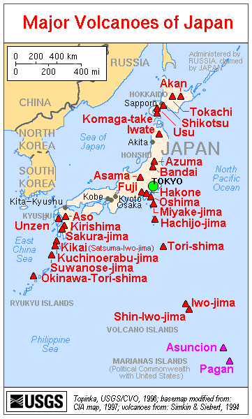
Map of volcanoes in Japan (USGS)
Japan is located at the junction of 4 tectonic plates - the Pacific, Philippine, Eurasian and North American plates, and its volcanoes are mainly located on 5 subduction-zone related volcanic arcs where the Pacific Plate descends under the North American Plate along the Kuril Trench and the Japan Trench and underneath the Philippine Sea Plate along the Izu-Bonin Trench. The Philippine Plate itself subducts beneath the Eurasian Plate at the western end, forming the Ryukyu Trench. The principal resulting volcanic ars are:
- Ryukyu Arc and Southwest Honshu Arcs in the south (Philippine plate subducting beneath between the Eurasian Plate),
- Izu-Bonin-Mariana Arc (subduction of Pacific plate beneath Philippine plate)
- Northeast Honshu and Kurile Arc in the north (subduction of Pacific plate beneath the N-American plate)

Besides intense volcanic activity, Japan is one of the places in the world most affected by frequent, and sometimes devastatingly large earthquakes. Its oceanic setting makes it vulnerable for tsunamis as well, as the tragedy of the 11 March 2011 8.9 earthquake and tsunami terrifyingly illustrated.

Record in historically documented eruptions
Japan's first documented historical eruption was from Aso volcano in 553 AD , the year after Buddhism was introduced from Korea. It holds a record in the number of historically documented eruptions.
Japan's largest historical eruption (Towada, 915 AD), 17 Japanese volcanoes had been documented in eruption, more than the rest of the world combined (including 10 in Europe).
Useful Links:

Volcanoes & Earthquakes - new app for Android
Départs garantis:
1-17 août 2025: Volcans et Épices - Mer des Moluques (Sulawesi, Indonésie)
1-14 oct. 2025: Désert, sels et volcans - Désert de Danakil (Éthiopie)
4-12 oct. 2025: Montagnes de Feu - du Stromboli à l'Etna - Eoliennes + Etna
6-21 oct. 2025: Du Krakatau à Bali - Java (Indonésie)
3-19 nov. 2025: Volcans et Épices - Mer des Moluques (Sulawesi, Indonésie)
= Places libres   = Départ garanti   = Quelques places disponibles   = Groupe fermé
Dernières nouvelles
mer., 11 juin 2025, 14:00

Suwanosejima volcano (Japan) - Smithsonian / USGS Weekly Volcanic Activity Report for 4 June-10 June 2025 (Continuing Activity)

The Japan Meteorological Agency (JMA) reported that eruptive activity at Suwanosejima's Ontake Crater continued during 2-9 June. Incandescence was observed nightly in webcam images. No explosions were detected, though ash-and-gas emissions were continuous during 4-7 June. ... Tout lire
mer., 11 juin 2025, 14:00

Aira volcano (Japan) - Smithsonian / USGS Weekly Volcanic Activity Report for 4 June-10 June 2025 (Continuing Activity)

The Japan Meteorological Agency (JMA) reported ongoing eruptive activity at Minamidake Crater (Aira Caldera's Sakurajima volcano) during 2-9 June. Nighttime crater incandescence was visible during 2-6 June. An explosion at 2341 on 2 June produced an ash plume that rose into weather clouds and ejected large blocks 300-1,000 m from the crater rim. ... Tout lire
Try our free app!
Volcanoes & Earthquakes - new app for Android
Android | iOS version

More on VolcanoDiscovery

Why is there advertising on this site?

Support us - Help us upgrade our services!

We truly love working to bring you the latest volcano and earthquake data from around the world. Maintaining our website and our free apps does require, however, considerable time and resources.
We need financing to increase hard- and software capacity as well as support our editor team. We're aiming to achieve uninterrupted service wherever an earthquake or volcano eruption unfolds, and your donations can make it happen! Every donation will be highly appreciated. If you find the information useful and would like to support our team in integrating further features, write great content, and in upgrading our soft- and hardware, please make a donation (PayPal).

Planned features:Thanks to your past donations, these features have been added recently:
Download and Upgrade the Volcanoes & Earthquakes app to get one of the fastest seismic and volcano alerts online:
Android | IOS
Thank you!
Copyright: VolcanoDiscovery ou autres sources indiquées.
Utilisation des documents: Les textes, les images et les vidéos de ce site internet sont protégées par copyright. Toute reproduction et tout usage sans accord préalable ne sont pas autorisés. Si vous désirez acquérir pour certains documents (photos, vidéos, textes ou autres) le droit de reproduction, d'édition et, plus généralement, de toute utilisation destinée à un usage public, qu'elle soit commerciale ou pas, vous êtes priés de nous contacter.
Volcanoes & Earthquakes
VolcanoDiscovery Home
Volcans | Séismes | Photos | Actualités | | Shop | App
Adventure & Study Travel
Tours to Volcanoes and Volcanic Areas: walking tours, photo tours, study tours
Voyages |
Get our newsletter!
Company info
Contact | Mentions légales | Terms & conditions
Follow us
Follow us on facebook Follow us on Instagram Follow us on Bluesky Follow us on Twitter Visit our Youtube channel
EN | DE | EL | ES | FR | IT | RU
VolcanoDiscovery GmbH, Germany, Reg. nr.: HRB 103744, EU Tax Id: DE 297 465 123 owned and created by
Dr. Tom Pfeiffer, volcanologist, volcano photographer, tour organizer member of
IAVCEI
IAVCEI
Vulkanologische Gesellschaft
Volcanological Society
Ecotourism Greece
Ecotourism Greece
RUV insurance
Insured by R+V
VolcanoDiscovery © 2004- All Rights Reserved | Privacy - Changer Préférences