Lascar Volcano
Updated: 29 avril. 2024 09:48 GMT -
stratovolcano 5592 m / 18,346 ft
Northern Chile, -23.37°S / -67.73°W
Condition actuelle: normal / en sommeil (1 sur 5)
Northern Chile, -23.37°S / -67.73°W
Condition actuelle: normal / en sommeil (1 sur 5)
Last update: 13 oct. 2023 (Smithsonian / USGS Weekly Volcanic Activity Report)
Láscar volcano in northern Chile is the most active of the northern Chilean Andes. Lascar is an andesitic-to-dacitic stratovolcano with 3 overlapping summit craters. Large lava flows are visible on its NW flanks.
Lascar is flanked 5 km to the east by the older, but higher Volcán Aguas Calientes stratovolcano.
Lascar has had a number of small to moderate explosive eruptions in historic times, as well as a few larger eruptions that caused ashfall hundreds of kilometers away. The biggest eruption of Lascar in historical time was in 1993 and produced pyroclastic flows, which traveled 8.5 km NW of the summit, and ashfall in Buenos Aires.
[smaller] [larger]
Eruptions du volcan Lascar: 2015, 2006-07, 2005, 2002, 2000, 1994-95, 1994, 1993-94, 1993, 1991-92, 1990, 1990, 1987-89, 1986, 1984, 1974, 1972, 1969, 1959-68, 1954, 1951-52, 1940, 1933, 1902, 1898, 1883-85, 1875, 1858, 1854, 1853(?), 1848
Derniers séismes proches
| Heure | Mag. / Profondeur | Distance / Lieu | |||
Introduction
The older Volcán Aguas Calientes has a well-developed summit crater and a lava flow near its summit may be of Holocene age.Younger Láscar volcano consists of 2 major edifices; activity built a cone to the east and then shifted to the west, where a second cone was built.
The largest eruption of Lascar took place about 26,500 years ago, and following the eruption of the Tumbres scoria flow about 9000 years ago, activity shifted back to the eastern cone, where 3 overlapping craters were formed.
---
Source: Smithsonian / GVP Lascar volcano information
Lascar Volcano Photos
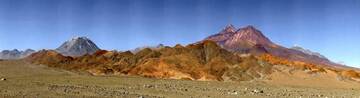
Volcan Lascar, Chili (Photo: Jiri VonDrak)
Eruptions du volcan Lascar
2006-07 activity
Après les émissions de cendres forte entre 18-23 avril 2006, plusieurs petites modérée des explosions phréatiques (probablement) s'est produite pendant le reste de 2006 et en 2007 à intervalles irréguliers.
Le 11 mars 2007 un nuage de cendres du Láscar est passée à 5.5-6.7 km d'altitude et drifted e. Le 23 mai 2007, un panache de cendres du Láscar est passée à 9.1 km d'altitude et a dérivé de SSE. Le 18 juillet 2007, un panache de cendres est passé à une altitude de 7,6-9,1 km et de drifted de ne. Après juillet 2007, Lascar calmé.
(Source : rapports mensuels GVP)
2006 April eruption
Une éruption du volcan Lascar à commencé le 18 Avril 2006 et a duré 5 jours. Le premier de 4 explosions sur le premier jour a produit un panache de cendres qui a atteint environ. 10 km au-dessus du volcan (environ 16 km d'altitude) et était visible depuis le El Abra Cooper mine de 220 km de nord-ouest du volcan.
Une éruption du volcan Lascar à commencé le 18 Avril 2006 et a duré 5 jours. Le premier de 4 explosions sur le premier jour a produit un panache de cendres qui a atteint environ. 10 km au-dessus du volcan (environ 16 km d'altitude) et était visible depuis le El Abra Cooper mine de 220 km de nord-ouest du volcan.
2005 eruption
Au cours de Février à mai 2005, un certain nombre de la plupart des petites éruptions phréatiques s'est produite au volcan Lascar.
Une éruption plus puissante s'est produite le 4 mai, la production d'une colonne de cendres qui a atteint une hauteur de 11 km et a causé la chute de fines cendres dans la ville de Salta située 285 km SSE du volcan.
1993 subplinian eruption
La plus grande éruption du volcan Lascar connue dans les temps historiques était en 1993: L'éruption explosive a commencé fin le 18 Avril avec une série de puissantes explosions et intensifié le 19 Avril, quand il a produit une colonne de cendres atteignant 20 à 22 plinienne km d'altitude au-dessus du cratère . Les grandes coulées pyroclastiques 7.5 km NO et de la lumière retombées de cendres (<0,1 mm) a été signalé dans la mesure où Buenos Aires, en Argentine, à 1500 km au SE du volcan.
La zone touchée par les cendres tombent parcouru plus de 850.000 km ² et étiré vers le nord-centre de l'Argentine, le sud du Paraguay, l'Uruguay et le sud du Brésil.
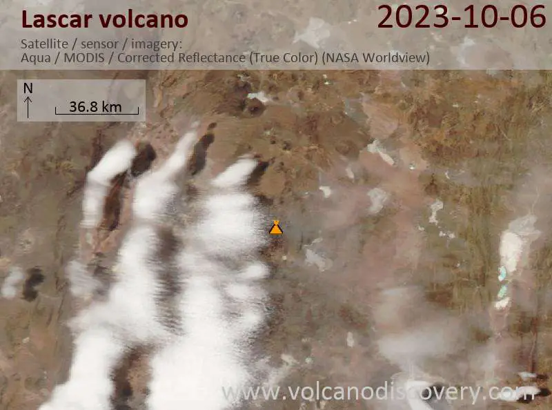
Latest satellite images