


Lascar Vulkan
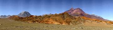
Láscar volcano in northern Chile is the most active of the northern Chilean Andes. Lascar is an andesitic-to-dacitic stratovolcano with 3 overlapping summit craters. Large lava flows are visible on its NW flanks.
Lascar is flanked 5 km to the east by the older, but higher Volcán Aguas Calientes stratovolcano.
Lascar has had a number of small to moderate explosive eruptions in historic times, as well as a few larger eruptions that caused ashfall hundreds of kilometers away. The biggest eruption of Lascar in historical time was in 1993 and produced pyroclastic flows, which traveled 8.5 km NW of the summit, and ashfall in Buenos Aires.
Ausbrüche des Lascar: 2015, 2006-07, 2005, 2002, 2000, 1994-95, 1994, 1993-94, 1993, 1991-92, 1990, 1990, 1987-89, 1986, 1984, 1974, 1972, 1969, 1959-68, 1954, 1951-52, 1940, 1933, 1902, 1898, 1883-85, 1875, 1858, 1854, 1853(?), 1848
Letzte Erdbeben in der Nähe
Beschreibung
The older Volcán Aguas Calientes has a well-developed summit crater and a lava flow near its summit may be of Holocene age.Younger Láscar volcano consists of 2 major edifices; activity built a cone to the east and then shifted to the west, where a second cone was built.
The largest eruption of Lascar took place about 26,500 years ago, and following the eruption of the Tumbres scoria flow about 9000 years ago, activity shifted back to the eastern cone, where 3 overlapping craters were formed.
---
Source: Smithsonian / GVP Lascar volcano information
Lascar Volcano Photos
Bedeutende Vulkanausbrüche: Lascar volcano
Additionally, there are 5 uncertain or discredited eruptions from Lascar volcano.
| Datum | Hinweis | VEI | Todesopfer | Schaden | |
|---|---|---|---|---|---|
Hist. dokumentiert | 3 | unbekannt | |||
| Summit craters Hist. dokumentiert | 2 | unbekannt | |||
| Central active crater Hist. dokumentiert | 1 | unbekannt | |||
Hist. dokumentiert | 3 | unbekannt | |||
Hist. dokumentiert | 3? | unbekannt | |||
?? | Unsicherer Ausbruch | 1 | unbekannt | ||
Hist. dokumentiert | 2 | unbekannt | |||
?? | Unsicherer Ausbruch | ? | unbekannt | ||
Hist. dokumentiert | 2 | unbekannt | |||
Hist. dokumentiert | 2 | unbekannt | |||
Hist. dokumentiert | 2 | unbekannt | |||
Hist. dokumentiert | 2 | unbekannt | |||
Hist. dokumentiert | 2 | unbekannt | |||
| Western crater of east summit cone Hist. dokumentiert | 4 | unbekannt | |||
Hist. dokumentiert | 2 | unbekannt | |||
Hist. dokumentiert | 1 | unbekannt | |||
| Western crater of east summit cone Hist. dokumentiert | 3 | unbekannt | |||
| Western crater of east summit cone Hist. dokumentiert | 3 | unbekannt | |||
| Western crater of east summit cone Hist. dokumentiert | 0 | unbekannt | |||
?? | Unsicherer Ausbruch | 1 | unbekannt | ||
?? | Unsicherer Ausbruch | 2? | unbekannt | ||
Hist. dokumentiert | 1 | unbekannt | |||
Hist. dokumentiert | 2 | unbekannt | |||
Hist. dokumentiert | 2? | unbekannt | |||
| East summit crater Hist. dokumentiert | 2? | unbekannt | |||
Hist. dokumentiert | 2 | unbekannt | |||
Hist. dokumentiert | 2 | unbekannt | |||
Hist. dokumentiert | 2? | unbekannt | |||
Hist. dokumentiert | 2 | unbekannt | |||
Ausbrüche des Vulkans Lascar
After the strong ash emissions between 18-23 April 2006, several small to moderate (probably) phreatic explosions occurred throughout the rest of 2006 and into 2007 at irregular intervals.
On 11 March 2007 an ash cloud from Láscar rose to 5.5-6.7 km altitude and drifted E. On 23 May, 2007, an ash plume from Láscar rose to an altitude of 9.1 km and drifted SSE. On 18 July 2007, an ash plume rose to altitudes of 7.6-9.1 km and drifted NE. After July, 2007, Lascar calmed down.
(Source: GVP monthly reports)
An eruption at Lascar volcano started on 18 April 2006 and lasted 5 days. The first of 4 explosions on the first day produced an ash plume that reached ca. 10 km above the volcano (ca. 16 km altitude) and was visible from the El Abra cooper mine 220 km NW of the volcano.
During February to May 2005, a number of mostly smaller phreatic eruptions occurred at Lascar volcano.
A more powerful eruption occurred on 4 May, producing an ash column that reached a height of 11 km and caused fine ash fall in the city of Salta located 285 km SSE of the volcano.
The largest eruption of Lascar volcano known in historical times was in 1993: The explosive eruption began late on 18 April with a series of powerful explosions and intensified on 19 April, when it produced a plinian ash column reaching 20-22 km height above the crater. Large pyroclastic flows traveled 7.5 km NW and light ashfall (<0.1 mm) was reported as far as Buenos Aires, Argentina, 1,500 km SE of the volcano.
The area affected by ash fall covered more than 850,000 sq km and stretched into north-central Argentina, southern Paraguay, Uruguay, and southern Brazil.
Lascar Volcano FAQ
+When was the last eruption of Lascar volcano?
The last confirmed eruption of Lascar occurred während 2022 - 2023.
+How often does Lascar volcano erupt?
Since 1848, Lascar volcano has had at least 30 historically documented eruptions. This means that it erupts on average every 5.9 years.
Many eruptions of Lascar have lasted more than one year. In total, the volcano has been in eruption during 52 out of 177 years until now. In other words, Lascar has been active at least one in 3.4 years on average. Note that this value is likely an underestimate, because the known history of eruptions from Lascar is likely incomplete, especially further back in time.
+How active is Lascar volcano at present?
Lascar volcano is very active: Since 1900, it has had 43 eruptions, and been active during 43 years out of 126 as of now. This means, Lascar has been in eruption one in 2.9 years on average. The last eruption was from 2022 until 2023 and ended 2 years ago.
+When was the largest eruption of Lascar volcano?
The largest eruption of Lascar volcano in historic times occurred im Jahr 1993. It ranks as a sub-plinian eruption with a magnitude 4 on the VEI (Volcanic Explosivity Index) scale.
Neueste Satellitenbilder
Lascar Vulkan Karten


