Paluweh Volcano
Updated: 29 avril. 2024 03:24 GMT -
stratovolcano 875 m / 2,871 ft
off Flores Island, Indonesia, -8.32°S / 121.71°E
Condition actuelle: normal / en sommeil (1 sur 5)
off Flores Island, Indonesia, -8.32°S / 121.71°E
Condition actuelle: normal / en sommeil (1 sur 5)
Last update: 1 juil. 2022 (Volcanic Ash Advisory)
Paluweh volcano (also known as Rokatenda), is the tip of a large, mostly submerged stratovolcano rising 3000 m from the sea floor. It forms a small 8 km wide island with the same name north of Flores Island. Paluweh has a complex summit composed of several overlapping craters and lava domes up to 900 m wide.
Several flank vents were formed by flank eruptions on a NW-trending fissure. The largest historical eruption of Paluweh in 1928 was highly explosive and produced a landslide triggering a tsumani.
[smaller] [larger]
Eruptions du volcan Paluweh: 2012-13, 1984-85(?), 1980-81, 1973, 1972-73, 1963-66, 1928, 1650
Derniers séismes proches
| Heure | Mag. / Profondeur | Distance / Lieu | |||
Paluweh Volcano Photos
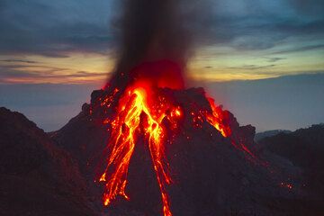
Avalanches rougeoyantes et cendres s'échappant au crépuscule du 1er décembre. Une partie de l'ancien dôme de lave Rokatenda de 1982, à gauche sur l'image. (Photo: Tom Pfe...
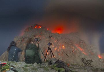
Melissa et Richard observant le dôme illuminé par le clair de lune (1er décembre) (Photo: Tom Pfeiffer)
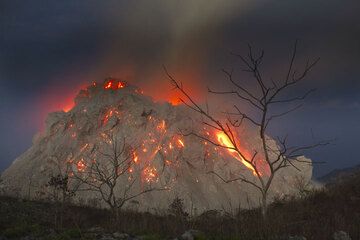
Des arbres nus se découpant sur le dôme de lave active du volcan Paluweh (mer de Flores, Indonésie), le 1er décembre 2012. (Photo: Tom Pfeiffer)
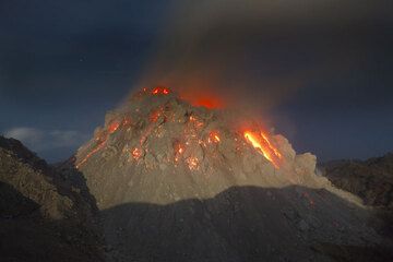
The new growing lava dome of Paluweh volcano, Flores Sea, Indonesia (Photo: Tom Pfeiffer)
Eruptions du volcan Paluweh
1984-85 uncertain eruptions
Reports suggesting activity in 1984-85 have been discredited.
Reports suggesting activity in 1984-85 have been discredited.
1980-81 eruption: explosive activity and lava dome growth
New activity began in November 1980 and continued intermittently to the end of January 1981. A new 40 m wide vent formed in early November on the upper NNE flank. On 9 November, an eruption column rose 1 km from the summit crater. Bombs fell nearby and 2 mm of ash were deposited 1 km to the W. On 18 January, a "hot air wave" was felt by the inhabitants of two E-flank villages. About 1,850 persons were evacuated from the danger zone. On 27 January ejecta set bushes afire near a flank village. Detonations from explosions on 31 January were heard at Kota Baru, Flores Island.
Activity decreased from February on.
By July, the lava dome was 200 m high, its volume exceeded 8.5 x 10E6 m3, and its summit had become the highest point on the volcano at 875 m above sea level. Activity increased again in August. Strombolian activity was observed on 22 August. On 24 August ocean water temperatures around the island were measured as high as 98°C. No casualties were reported, but inhabitants evacuated the area. Crops and fishing boats were damaged.
Explosive activity resumed on 5 September producing a 1-km-high plume. This activity was followed by the destruction of the lava dome. Pyroclastic flows damaged 36 buildings in a village, including a church and five shelters, but caused no fatalities, because the people had been evacuated.
After the destruction of the lava dome, activity probably ceased, as there are no more reports available.
---
Source: GVP monthly reports
After residents evacuated, pyroclastic flows burnt 36 buildings.
1973 eruption
Paluweh erupted in January 1973, ejecting ash and bombs to 100 m above the crater. Large amounts of vegetation were destroyed.
Paluweh erupted in January 1973, ejecting ash and bombs to 100 m above the crater. Large amounts of vegetation were destroyed.
1963-66 Eruptions
Explosive activity between 1963 and 1966 produced pyroclastic flows, lava flows and a lava dome. Fatalities were caused by pyroclastic flows.
Explosive activity between 1963 and 1966 produced pyroclastic flows, lava flows and a lava dome. Fatalities were caused by pyroclastic flows.
1928 eruption and tsunami
On 4 August 1928, a large explosive eruption caused a landslide, which in turn triggered a tsunami with waves up to 5-10 m height, killing more than 160 people.
On 4 August 1928, a large explosive eruption caused a landslide, which in turn triggered a tsunami with waves up to 5-10 m height, killing more than 160 people.
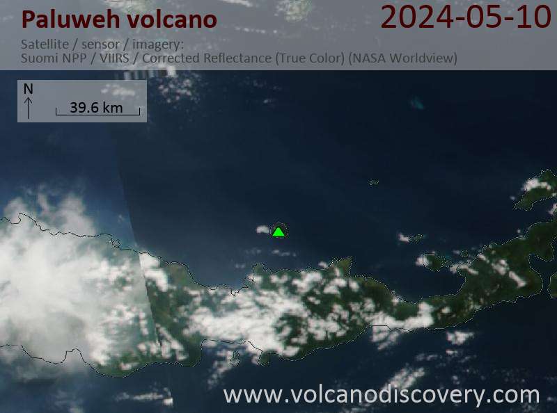
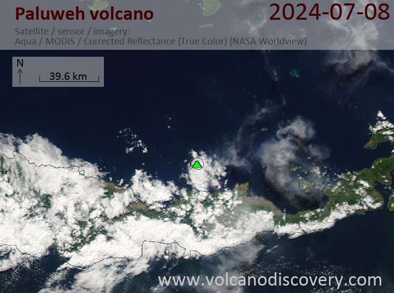
Latest satellite images