The volcanoes of Ecuador belong to the Northern Volcanic Zone of the Andes, which is the result of subduction of the Nazca Pacific oceanic plate under the continental plate of South America. In Ecuador, the volcanoes occur on 4 chains.
All active (and a few extinct) volcanoes of Ecuador are listed.
| Дата | Вулкан | VEI | Область | Летальные исходы | Ущерб | |
|---|---|---|---|---|---|---|
| Sangay | 2 | Ecuador | неизвестно | |||
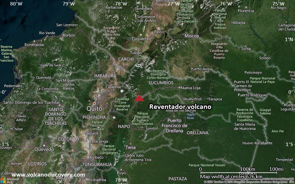
| Reventador | 2 | Ecuador | неизвестно | |||
| Cotopaxi Summit crater | 2 | Ecuador | неизвестно | |||
| 2021 Мар 5 (извержение | Sangay | 2 | Ecuador | среднее | Информация | |
| Sangay | 2 | Ecuador | неизвестно | |||
| Sangay Summit crater | 1 | Ecuador | неизвестно | |||
| Sangay Summit crater | 2 | Ecuador | неизвестно | |||
| Sangay Summit crater | 2 | Ecuador | неизвестно | |||
| Tungurahua Summit crater | 3 | Ecuador | неизвестно | |||
| Cotopaxi Summit crater | 2 | Ecuador | неизвестно | |||
| Sangay Summit crater complex | 2 | Ecuador | неизвестно | |||
| Sangay Summit crater complex | 2 | Ecuador | неизвестно | |||
| Sangay Summit crater complex | 2 | Ecuador | неизвестно | |||
| Tungurahua Summit crater | ? | Ecuador | неизвестно | |||
| Tungurahua Summit crater | 2 | Ecuador | неизвестно | |||
| 2011 Апр (извержение | Tungurahua | 4 | Ecuador | легкое | Информация | |
| Sangay | 3 | Ecuador | неизвестно | |||
| Tungurahua Summit crater | 3? | Ecuador | неизвестно | |||
| 2010 Ноя (извержение | Tungurahua | 3 | Ecuador | легкое | Информация | |
| Tungurahua Summit crater | 3 | Ecuador | неизвестно | |||
| 2010 Янв (извержение | Tungurahua | 3 | Ecuador | легкое | Информация | |
| 1976 Авг 12 (извержение | Sangay | 3 | Ecuador | 2 | неизвестно | Информация |
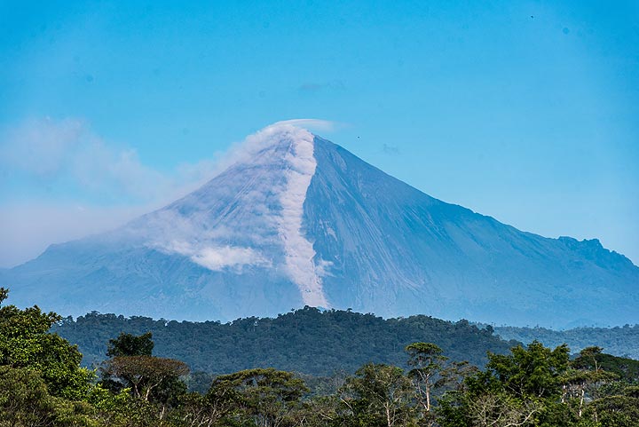
The last volcanic eruption в Эквадор was from Cotopaxi volcano during 2022 - 2023.
The first historically documented eruption occurred вокруг 1532 AD from Cotopaxi volcano.
Volcanoes в Эквадор erupt almost every year. Since the first historically documented eruption 1532 ADв Эквадор, historic sources have shown nearly continuous volcanic activity: The Global Volcanism Project counts 147 historic eruptions until now, spanning a total of 327 out of 493 years. In other words, a volcano в Эквадор is active roughly every one in 1.5 years on average. This value is likely underestimated, because the record of historically documented activity is likely inclomplete the further back in time we look.
Эквадор is volcanically extremely active: Since 1900, at least 7 volcanoes в Эквадор have been active. Almost every year, at least one volcano has erupted в Эквадор. The last volcano to erupt в Эквадор was Cotopaxi volcano. Its was active from 2022 until 2023 and ended 2 years ago.
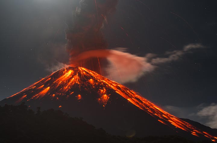
The largest eruption в Эквадор in historic times was from Reventador volcano. It occurred during 2002 - 2003. It ranks as a sub-plinian eruption with a magnitude 4 on the VEI (Volcanic Explosivity Index) scale.
| Дата и время | Маг / Глуб. | Ближайший вулкан / Расположение | |||
|---|---|---|---|---|---|
| 28 мая 04:24 (GMT -5) | 3.6 71 km | 59 km S от | 46 km к северо-востоку от Azogues, Canar, Эквадор I FELT IT | Более | |
| Вторник, 27 мая 2025 GMT (3 земл.) | |||||
| 27 мая 06:29 (Guayaquil) | 4.3 168 km | 47 km E от | 11 km к югу от Пуйо, Пастаса, Эквадор I FELT IT | Более | |
| 27 мая 03:56 (GMT -5) | 3.9 5 km | 167 km W от | 12 km к северо-востоку от Портовьехо, Эквадор I FELT IT - 2 отчетов | Более | |
| 27 мая 00:44 (GMT -5) | 2.7 24 km | 156 km NW от | 7.1 km к югу от Esmeraldas, Эсмеральдас, Эквадор | Более | |
| Воскресенье, 25 мая 2025 GMT (1 земл.) | |||||
| 25 мая 03:41 (GMT -5) | 3.6 1 km | 12 km N от | 39 km к югу от Кито, Пичинча, Эквадор I FELT IT - 5 отчетов | Более | |
| Пятница, 23 мая 2025 GMT (1 земл.) | |||||
| 22 мая 22:25 (GMT -5) | 2.7 0 km | 63 km NE от | Ecuador I FELT IT | Более | |
| Дата | Маг | Область | Летальные исходы | Ущерб | |
|---|---|---|---|---|---|
| 2023 Mar 18 | 6.8 | Azuay, El Oro, Guayas; Peru Tumbes | 15 | тяжелое | Info |
| 2016 Apr 16 | 7.8 | Near West Coast Manabi, Esmeraldas | 663 | катастрофическое | Info |
| 1996 Mar 28 | 5.9 | Cotopaxi, Pastaza, Tungurahua, Ambato | 27 | среднее | Info |
| 1987 Mar 6 | 7.2 | Napo Province, Quito, Tulcan | 5,000 | катастрофическое | Info |
| 1976 Apr 9 | 6.7 | Esmeraldos | 10 | среднее | Info |
| 1960 Jul 30 | ? | Ecuador | 11 | легкое | Info |
| 1958 Jan 19 | 7.6 | Colombia-ecuador | 115 | среднее | Info |
| 1949 Aug 5 | 6.5 | Tungurahua | 6,000 | среднее | Info |
| 1942 May 14 | 7.9 | Guayaquil | 200 | легкое | Info |
| 1929 Jul 25 | ? | Murco | 50-100 (*) | тяжелое | Info |
| 1924 Mar 3 | 6.9 | Ecuador | 40 | легкое | Info |
| 1923 Feb 24 | 6.8 | Ecuador | 50-100 (*) | неизвестно | Info |
| 1913 Feb 24 | 7.7 | Gonzanama, San Pedro, Molleture | 100-1,000 (*) | тяжелое | Info |
| 1906 Jan 31 | 8.8 | Off Coast | 1,000 | тяжелое | Info |
Самое смертоносное землетрясение В Эквадор См. недавние землетрясения было ###СМЕРТЕЛЬНЫМ###. В результате пострадало ХХХ погибших и неизвестное количество раненых. Это было 4-е самое разрушительное землетрясение В Эквадор из когда-либо зарегистрированных.
Землетрясение, причинившее наибольший ущерб, было the magnitude 7.8 earthquake в ![]() Эквадор, Эсмеральдас on апр., 16, 2016. Это нанесло ХХХ погибших и оценочный $3.3 миллиард долларов США (сегодняшний эквивалент) общего экономического ущерба.
Эквадор, Эсмеральдас on апр., 16, 2016. Это нанесло ХХХ погибших и оценочный $3.3 миллиард долларов США (сегодняшний эквивалент) общего экономического ущерба.
См. недавние землетрясения, как минимум 27 землетрясений унесло примерно ###TOTALFAT ### погибших ###ГДЕ###.
Нанесено 42 повреждений или смертоносные землетрясения в этот период, которые повлекли за собой экономический ущерб в размере ок. $5.2 миллиард долларов США в сочетании.