The volcanoes of Ecuador belong to the Northern Volcanic Zone of the Andes, which is the result of subduction of the Nazca Pacific oceanic plate under the continental plate of South America. In Ecuador, the volcanoes occur on 4 chains.
All active (and a few extinct) volcanoes of Ecuador are listed.
| Fecha | Volcán | VEI | Región | Fallecidos | Daños | |
|---|---|---|---|---|---|---|
| Sangay | 2 | Ecuador | desconocido | |||
| Reventador | 2 | Ecuador | desconocido | |||
| Cotopaxi Summit crater | 2 | Ecuador | desconocido | |||
| 2021 mar 5 (erupción | Sangay | 2 | Ecuador | moderado | Información | |
| Sangay | 2 | Ecuador | desconocido | |||
| Sangay Summit crater | 1 | Ecuador | desconocido | |||
| Sangay Summit crater | 2 | Ecuador | desconocido | |||
| Sangay Summit crater | 2 | Ecuador | desconocido | |||
| Tungurahua Summit crater | 3 | Ecuador | desconocido | |||
| Cotopaxi Summit crater | 2 | Ecuador | desconocido | |||
| Sangay Summit crater complex | 2 | Ecuador | desconocido | |||
| Sangay Summit crater complex | 2 | Ecuador | desconocido | |||
| Sangay Summit crater complex | 2 | Ecuador | desconocido | |||
| Tungurahua Summit crater | ? | Ecuador | desconocido | |||
| Tungurahua Summit crater | 2 | Ecuador | desconocido | |||
| 2011 abr (erupción | Tungurahua | 4 | Ecuador | ligero | Información | |
| Sangay | 3 | Ecuador | desconocido | |||
| Tungurahua Summit crater | 3? | Ecuador | desconocido | |||
| 2010 nov (erupción | Tungurahua | 3 | Ecuador | ligero | Información | |
| Tungurahua Summit crater | 3 | Ecuador | desconocido | |||
| 2010 ene (erupción | Tungurahua | 3 | Ecuador | ligero | Información | |
| 1976 ago 12 (erupción | Sangay | 3 | Ecuador | 2 | desconocido | Información |
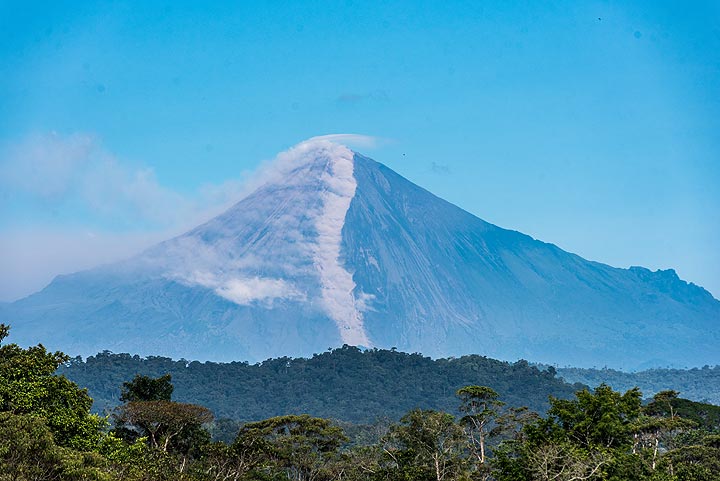
The last volcanic eruption en el Ecuador was from Cotopaxi volcano during 2022 - 2023.
The first historically documented eruption occurred alrededor de 1532 AD from Cotopaxi volcano.
Volcanoes en el Ecuador erupt almost every year. Since the first historically documented eruption 1532 ADen el Ecuador, historic sources have shown nearly continuous volcanic activity: The Global Volcanism Project counts 147 historic eruptions until now, spanning a total of 327 out of 493 years. In other words, a volcano en el Ecuador is active roughly every one in 1.5 years on average. This value is likely underestimated, because the record of historically documented activity is likely inclomplete the further back in time we look.
Ecuador is volcanically extremely active: Since 1900, at least 7 volcanoes en el Ecuador have been active. Almost every year, at least one volcano has erupted en el Ecuador. The last volcano to erupt en el Ecuador was Cotopaxi volcano. Its was active from 2022 until 2023 and ended 2 years ago.
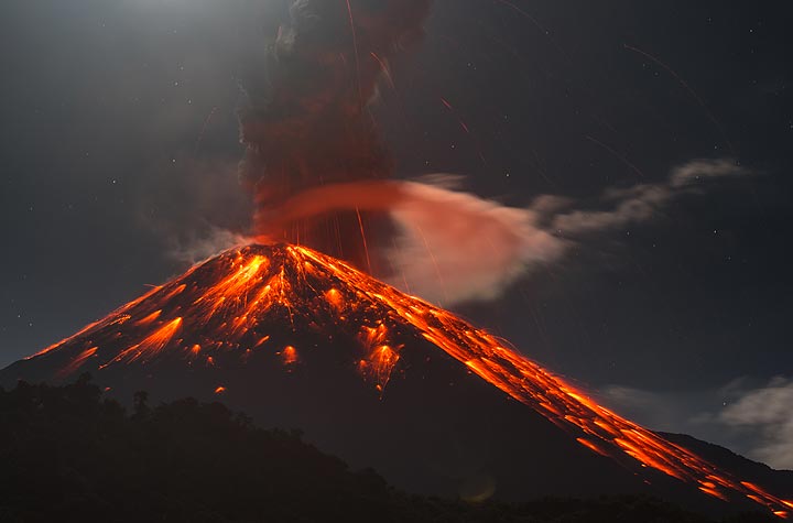
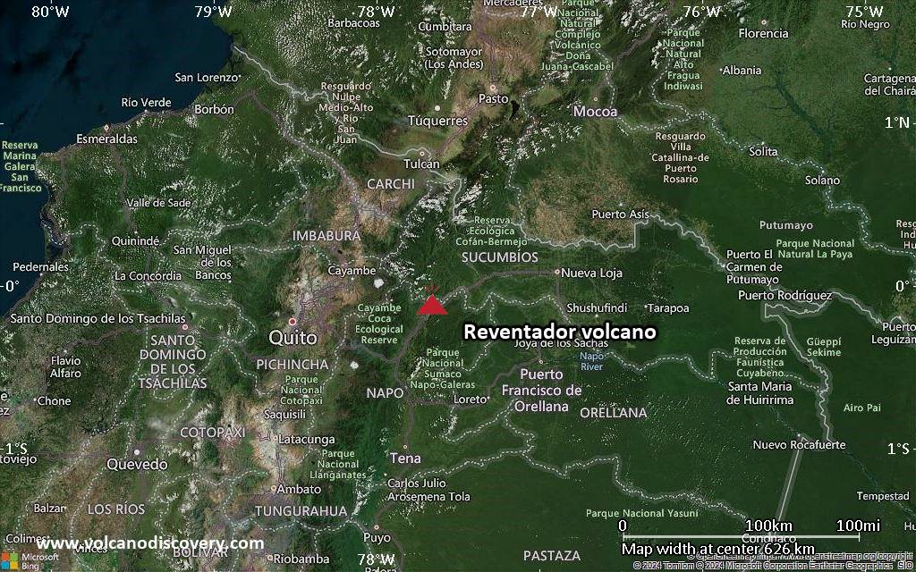
The largest eruption en el Ecuador in historic times was from Reventador volcano. It occurred during 2002 - 2003. It ranks as a sub-plinian eruption with a magnitude 4 on the VEI (Volcanic Explosivity Index) scale.
| Fecha y hora | Mag / Prof. | Volcán más cercano / Ubicación | |||
|---|---|---|---|---|---|
| 27 may 06:29 (Guayaquil) | 4.3 168 km | 47 km E de | 11 km al sur de Puyo, Provincia de Pastaza, Ecuador I FELT IT | Más | |
| 27 may 03:56 (GMT -5) | 3.9 5 km | 167 km O de | 12 km al noreste de Portoviejo, Provincia de Manabi, Ecuador I FELT IT - 2 reports | Más | |
| 27 may 00:44 (GMT -5) | 2.7 24 km | 156 km NO de | Cerca De La Costa De Ecuador | Más | |
| domingo, 25 mayo 2025 GMT (1 sismo) | |||||
| 25 may 03:41 (GMT -5) | 3.6 1 km | 12 km N de | 39 km al sur de Quito, Pichincha, Ecuador I FELT IT - 5 reports | Más | |
| miércoles, 21 mayo 2025 GMT (2 sismos) | |||||
| 20 may 23:25 (Guayaquil) | 3.8 10 km | 238 km SO de | Near Coast of Ecuador I FELT IT - 1 report | Más | |
| 20 may 21:44 (GMT -5) | 2.9 7 km | 13 km O de | 26 km al suroeste de Quito, Pichincha, Ecuador I FELT IT | Más | |
| Fecha | Mag | Región | Fallecidos | Daños | |
|---|---|---|---|---|---|
| 2023 Mar 18 | 6.8 | Azuay, El Oro, Guayas; Peru Tumbes | 15 | pesado | Info |
| 2016 Apr 16 | 7.8 | Near West Coast Manabi, Esmeraldas | 663 | catastrófico | Info |
| 1996 Mar 28 | 5.9 | Cotopaxi, Pastaza, Tungurahua, Ambato | 27 | moderado | Info |
| 1987 Mar 6 | 7.2 | Napo Province, Quito, Tulcan | 5,000 | catastrófico | Info |
| 1976 Apr 9 | 6.7 | Esmeraldos | 10 | moderado | Info |
| 1960 Jul 30 | ? | Ecuador | 11 | ligero | Info |
| 1958 Jan 19 | 7.6 | Colombia-ecuador | 115 | moderado | Info |
| 1949 Aug 5 | 6.5 | Tungurahua | 6,000 | moderado | Info |
| 1942 May 14 | 7.9 | Guayaquil | 200 | ligero | Info |
| 1929 Jul 25 | ? | Murco | 50-100 (*) | pesado | Info |
| 1924 Mar 3 | 6.9 | Ecuador | 40 | ligero | Info |
| 1923 Feb 24 | 6.8 | Ecuador | 50-100 (*) | desconocido | Info |
| 1913 Feb 24 | 7.7 | Gonzanama, San Pedro, Molleture | 100-1,000 (*) | pesado | Info |
| 1906 Jan 31 | 8.8 | Off Coast | 1,000 | pesado | Info |
El terremoto más mortífero en el Ecuador desde 1900 fue the magnitude 6.5 earthquake en el ![]() Ecuador, Provincia de Tungurahua on agosto, 5, 1949. Resultó en 6,000 muertes y un número desconocido de personas heridas. Este fue el 4. terremoto más desastroso en el Ecuador jamás registrado.
Ecuador, Provincia de Tungurahua on agosto, 5, 1949. Resultó en 6,000 muertes y un número desconocido de personas heridas. Este fue el 4. terremoto más desastroso en el Ecuador jamás registrado.
El terremoto que causó más daños fue the magnitude 7.8 earthquake en el ![]() Ecuador, Esmeraldas on abril, 16, 2016. Causó 663 muertes y $3.3 mil millones de dólares estadounidenses (el equivalente actual) en daños económicos totales.
Ecuador, Esmeraldas on abril, 16, 2016. Causó 663 muertes y $3.3 mil millones de dólares estadounidenses (el equivalente actual) en daños económicos totales.
Desde 1900, al menos 27 terremotos se han cobrado un total estimado de 14,000 muertes en el Ecuador.
Ha habido 42 terremotos dañinos durante este período que han causado pérdidas económicas de aprox. $5.2 mil millones de dólares estadounidenses combinado.