Reykjanes Volcano
Updated: 5 мая 2024 01:29 GMT -
Crater rows 230 m / 755 ft
Reykjanes peninsula (SW Iceland), 63.89°N / -22.52°W
Current status: erupting (4 out of 5)
Reykjanes peninsula (SW Iceland), 63.89°N / -22.52°W
Current status: erupting (4 out of 5)
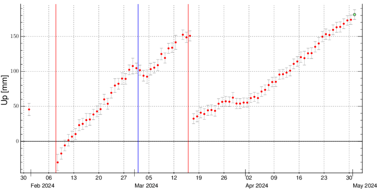
Last update: 3 мая 2024 (pressure in magma chamber continues to be elevated, new eruption is not ruled out)
Reykjanes volcano on the peninsula of the same name is a vast fissure system in SW Iceland. It is located where the Mid Atlantic Ridge emerges onto land.
It forms a vast area with many eruptive fissures, lava fields, hot springs and mud pools. In 2000, a large earthquake lowered the water level in Lake Kleifarvatn by 5 metres, but has gradually returned to normal since then.
[smaller] [larger]
Reykjanes volcano eruptions: 1211, 1226, 2023 (Dec), 2024 (Jan), 2024 (Feb), 2024 (Mar)
Latest nearby earthquakes
| Время | Магнитуда / Глубина | Расстояние / Местоположение | |||
| 4 мая 01:06 (Reykjavik) | 1.6 6.8 km | Более | |||
| Пятница, 3 мая 2024 GMT (1 земл.) | |||||
| 3 мая 11:11 (Reykjavik) | 2.0 10 km | 34 km к юго-западу | Более | ||
| Среда, 1 мая 2024 GMT (1 земл.) | |||||
| 1 мая 21:04 (Reykjavik) | 1.6 4.8 km | Более | |||
| Суббота, 27 апреля 2024 GMT (1 земл.) | |||||
| 27 апр 06:39 (Reykjavik) | 1.7 10 km | 29 km к юго-западу | Более | ||
| Понедельник, 22 апреля 2024 GMT (2 земл.) | |||||
| 22 апр 04:54 (Reykjavik) | 1.9 5.6 km | 13 km к юго-западу | Более | ||
| 22 апр 04:53 (Reykjavik) | 3.1 5.8 km | 13 km к юго-западу | Более | ||
Background
The Reykjanes volcanic system at the SW tip of the Reykjanes Peninsula, where the Mid Atlantic Ridge rises above sea level, comprises a broad area of postglacial basaltic crater rows and small shield volcanoes.The Reykjanes volcanic system is the westernmost of a series of four closely-spaced fissure systems that extend diagonally across the Reykjanes Peninsula. Most of the volcanic system is covered by Holocene lavas and eruptions have occurred in historical time during the 13th century at several locations on the NE-SW-trending fissure system.
---
Source: GVP, Smithsonian Institute
Reykjanes Volcano Photos

Геотермальная зона Гуннухвер, полуостров Рейкьянес, Исландия. (Photo: Janka)

Вид с воздуха на активный конус и поток лавы в юго-западном направлении. На заднем плане видно южное побережье Рейкьянеса. (Photo: World-Geographic)...
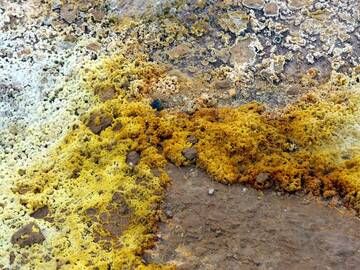
Месторождения серы в геотермальной зоне Гуннухвер, полуостров Рейкьянес, Исландия. (Photo: Janka)

Вид на красочную птичью скалу Крисувикурбьярг на южном побережье полуострова Рейкьянес, Исландия. (Photo: Janka)...
Latest satellite images