Karymsky Volcano
Updated: 25. Jan. 2025 19:36 GMT -
Stratovolcano 1536 m / 5,039 ft
Kamchatka, 54.05°N / 159.43°E
Aktueller Status: Ausbruch (4 von 5)
Kamchatka, 54.05°N / 159.43°E
Aktueller Status: Ausbruch (4 von 5)
Last update: 22 Jan 2025 (Smithsonian / USGS Weekly Volcanic Activity Report)
Karymsky is the most active volcano of Kamchatka's eastern volcanic zone and a perfect symmetrical stratovolcano. Ash eruptions from Karymski can come in the way of aircraft flight routes across the N Pacific. Karymsky, the most active volcano of Kamchatka's eastern volcanic zone in one of the world's volcanoes with persistent activity and has been erupting for at least about 500 years.
[smaller] [larger]
Ausbrüche des Karymsky: 1771, 1830, 1852, 1854, 1908, 1911, 1912, 1915, 1921, 1923, 1925, 1929, 1932, 1933, 1934, 1938, 1940, 1943, 1945, 1946, 1947, 1952, 1953, 1955, 1956, 1960, 1965, 1967, 1970, 1982, 1983, 1985, 1990, 1993, 1996 - ongoing
Letzte Erdbeben in der Nähe
Beschreibung
Much of the cone is surrounded by lava flows no older than 200 years. Historical eruptions have been vulcanian or vulcanian-strombolian with moderate explosive activity and occasional lava flows from the summit crater.The cone has been constructed during the past 2000 years within a 5-km-wide caldera that formed about 9,000 year ago within a complex system of overlapping calderas. The caldera cuts the south side of the older Dvor volcano and is located outside the north margin of a large, still older caldera (the mid-Pleistocene Polovinka caldera), which contains the smaller Akademia Nauk and Odnoboky calderas.
Most seismicity preceding Karymsky eruptions originated beneath Akademia Nauk caldera, which is located immediately south of Karymsky volcano.
---
Source: GVP, Smithsonian Institution
Karymsky Volcano Photos
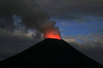
Karymsky-Vulkan leuchtet in der Abenddämmerung. (Photo: mlyvers)
Der Gipfelkegel des Karymsky mit Teilen der Wände der Karymsky-Caldera dahinter. (Photo: Tom Pfeiffer)
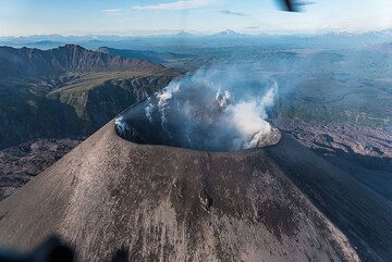
Auf unsere Bitte hin erklären sich die Helikopterpiloten bereit, einen Rundflug über den steilen und tiefen Karymsky-Krater zu machen. (Photo: Tom Pfeiffer)
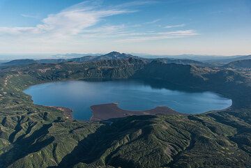
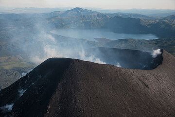
Der aktive Caldera-See des Vulkans Akademia Nauk südöstlich von Karymsky vom Hubschrauber aus gesehen. (Photo: Tom Pfeiffer)
Significant volcanic eruptions: Karymsky volcano
Datum | Hinweis | VEI | Todesopfer | Schaden | ||
---|---|---|---|---|---|---|
Historical obs./docs. | ? | unbekannt | ||||
Historical obs./docs. | 3 | unbekannt | ||||
Historical obs./docs. | 2 | unbekannt | ||||
Summit crater Historical obs./docs. | 3 | unbekannt | ||||
Historical obs./docs. | 3 | unbekannt | ||||
Summit crater Historical obs./docs. | 2 | unbekannt | ||||
Summit and upper south flank Historical obs./docs. | 3 | unbekannt | ||||
New summit crater SW of 1970-82 crater Historical obs./docs. | 3 | unbekannt | ||||
1996 Jan 2 (eruption | Tsunami recorded Historical obs./docs. | 2 | unbekannt | |||
Discredited Eruption | ||||||
Historical obs./docs. | 3 | unbekannt | ||||
Historical obs./docs. | 1 | unbekannt | ||||
Historical obs./docs. | 3 | unbekannt | ||||
Historical obs./docs. | 1 | unbekannt | ||||
Historical obs./docs. | 2 | unbekannt | ||||
Historical obs./docs. | 2 | unbekannt |
Sources: NOAA National Centers for Environmental Information (NCEI), Global Significant Volcanic Eruptions Database. doi:10.7289/V5TD9V7K | Global Volcanism Project / Smithsonian Institution
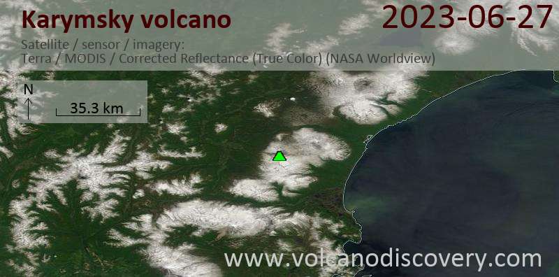
Latest satellite images
Karymsky Volcano Tours
Kamchatka (Russia)
Kamchatka - Land of Colors
volcano expedition to Kamchatka
16-19 days - Leicht bis mittel
Preis 0 €
Preis 0 €
zur Zeit keine Termine
Karymsky Volcano Maps
Below is a selection of maps showing the location and surroundings of the volcano at various resolutions based on aerial-imagery / terrain maps. Feel free to use them for non-commercial purposes on your blog or website as long as you credit them with a link back to this page (click to copy it).
Satellite/aerial-type map of Karymsky volcano (world scale)
Terrain-type map of Karymsky volcano (world scale)
Satellite/aerial-type map of Karymsky volcano (region scale large)
Terrain-type map of Karymsky volcano (region scale large)
Satellite/aerial-type map of Karymsky volcano (region scale medium)
Terrain-type map of Karymsky volcano (region scale medium)
Satellite/aerial-type map of Karymsky volcano (region scale small)
Terrain-type map of Karymsky volcano (region scale small)
Satellite/aerial-type map of Karymsky volcano (local scale large)
Terrain-type map of Karymsky volcano (local scale large)
Satellite/aerial-type map of Karymsky volcano (local scale medium)
Terrain-type map of Karymsky volcano (local scale medium)
Satellite/aerial-type map of Karymsky volcano (local scale small)
Terrain-type map of Karymsky volcano (local scale small)
Satellite/aerial-type map of Karymsky volcano (scale of 10s of km)
Terrain-type map of Karymsky volcano (scale of 10s of km)
Satellite/aerial-type map of Karymsky volcano (scale of 20-40 km)
Terrain-type map of Karymsky volcano (scale of 20-40 km)
Satellite/aerial-type map of Karymsky volcano (scale of approx. 10-20 km)
Terrain-type map of Karymsky volcano (scale of approx. 10-20 km)
Satellite/aerial-type map of Karymsky volcano (scale of 5-10 km)
Satellite/aerial-type map of Karymsky volcano (scale of few kilometers)