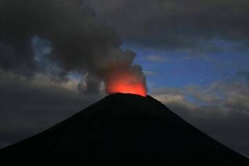
| RSS | EN | DE | EL | ES | FR | IT | RU

Karymsky Volcano

Updated: Aug 3, 2025 18:56 GMT -
Stratovolcano
Kamchatka, 54.05°N / 159.43°E
Summit height: 1536 m / 5,039 ft
Current status: erupting (4 out of 5)
Last update: 30 Jul 2025 (Smithsonian / USGS Weekly Volcanic Activity Report)

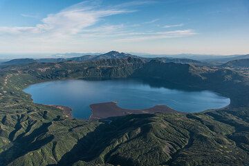
Karymsky is the most active volcano of Kamchatka's eastern volcanic zone and a perfect symmetrical stratovolcano. Ash eruptions from Karymski can come in the way of aircraft flight routes across the N Pacific. Karymsky, the most active volcano of Kamchatka's eastern volcanic zone in one of the world's volcanoes with persistent activity and has been erupting for at least about 500 years.

[smaller] [larger]
Typical eruption style: Doninantly explosive, construction of lava domes, near constant activity.
Karymsky volcano eruptions: 1771, 1830, 1852, 1854, 1908, 1911, 1912, 1915, 1921, 1923, 1925, 1929, 1932, 1933, 1934, 1938, 1940, 1943, 1945, 1946, 1947, 1952, 1953, 1955, 1956, 1960, 1965, 1967, 1970, 1982, 1983, 1985, 1990, 1993, 1996 - ongoing

Latest nearby earthquakes

Date and TimeMag / DepthDistance / Location

Background

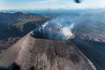
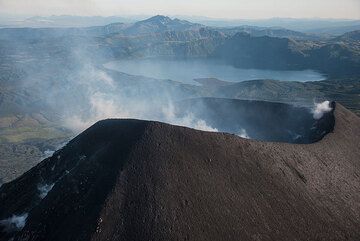
Much of the cone is surrounded by lava flows no older than 200 years. Historical eruptions have been vulcanian or vulcanian-strombolian with moderate explosive activity and occasional lava flows from the summit crater.
The cone has been constructed during the past 2000 years within a 5-km-wide caldera that formed about 9,000 year ago within a complex system of overlapping calderas. The caldera cuts the south side of the older Dvor volcano and is located outside the north margin of a large, still older caldera (the mid-Pleistocene Polovinka caldera), which contains the smaller Akademia Nauk and Odnoboky calderas.
Most seismicity preceding Karymsky eruptions originated beneath Akademia Nauk caldera, which is located immediately south of Karymsky volcano.
---

Source: GVP, Smithsonian Institution

Karymsky Volcano Photos

Significant volcanic eruptions: Karymsky volcano

In the past 10,000 years, Karymsky has had at least 54 confirmed volcanic eruptions, out of which 38 are documented by historical records, while the others can be inferred from geological evidence.
There is one uncertain or discredited eruption in 1985 from Karymsky volcano.
The table below lists all known eruptions (date in bold face) of Karymsky volcano since around 1900. Updates on the most recent volcanic activity of Karymsky can be found on the news page of Karymsky volcano.
DateNoteVEIDeathsDamage
2024 Jun 20 -
Historical obs./docs.
?
2020 Apr 1 - 2022 Aug 7
Historical obs./docs.
3
2019 Feb 16 - Sep 24
Historical obs./docs.
2
2017 Jun 4 - 2018 Sep 30Summit crater
Historical obs./docs.
3
2018 Apr 28 - Sep 30
Historical obs./docs.
3
2016 Oct 5 - Oct 8Summit crater
Historical obs./docs.
2
2001 Nov 15 - 2016 Apr 1Summit and upper south flank
Historical obs./docs.
3
1996 Jan 2 - 2000 Dec 20 ?New summit crater SW of 1970-82 crater
Historical obs./docs.
3
1996 Jan 2
(eruption 1996 Jan 2 - 2000 Dec 20 ?)
Tsunami recorded
Historical obs./docs.
2
1985 May 3 ?
Discredited Eruption
1970 May 11 - 1982 Oct 11
Historical obs./docs.
3
1967 Nov 16 ±15 d.
Historical obs./docs.
1
1965 May 15 ±5 d. - 1967 Feb 16 ±15 d.
Historical obs./docs.
3
1960 Apr 16 ±15 d. - 1964 Dec 16 ±15 d.
Historical obs./docs.
3
1956 Mar 16 ±15 d. - 1957 Feb 16 ±15 d.
Historical obs./docs.
1
1955 Jul 2 ±182 d.
Historical obs./docs.
2
1953 Jul 2 ±182 d.
Historical obs./docs.
2
1952 Nov 16 ±15 d.
Historical obs./docs.
2
1947 Apr
Historical obs./docs.
2
1946 Sep - Oct
Historical obs./docs.
2
1946 Apr
Historical obs./docs.
2
1945 Sep
Historical obs./docs.
2
1943 Feb 1 ±30 d.
Historical obs./docs.
2
1940
Historical obs./docs.
2
1938 Oct
Historical obs./docs.
2
1934 Nov - 1935 Feb
Historical obs./docs.
2
1933 Sep - Oct
Historical obs./docs.
2
1932 Jun
Historical obs./docs.
2
1929
Historical obs./docs.
2
1925 Jul
Historical obs./docs.
2
1923 Feb
Historical obs./docs.
2
1921 Sep
Historical obs./docs.
2
1915
Historical obs./docs.
2
1912 Jan
Historical obs./docs.
2
1911
Historical obs./docs.
2
1908
Historical obs./docs.
2
Remark:
Our list of volcanic eruptions closely follows the database of eruptions of the Smithsonian's Global Volcanism Project (GVP), the internationally most recognized data source for volcanic eruptions, but also includes significant eruptive episodes or related volcano events. "Volcanic eruptions" are usually to be understood as sequences of individual eruptive episodes that can follow each other, or even overlap (if several vents are involved), and can last many years, decades or even longer. For example, the current activity of Stromboli volcano is understood as a single eruption that has been ongoing since 1934.
Sources: NOAA National Centers for Environmental Information (NCEI), Global Significant Volcanic Eruptions Database. doi:10.7289/V5TD9V7K | Global Volcanism Project / Smithsonian Institution

Karymsky Volcano FAQ

+When was the last eruption of Karymsky volcano?

+How often does Karymsky volcano erupt?

+How active is Karymsky volcano at present?

+When was the largest eruption of Karymsky volcano?

Latest satellite images

Karymsky satellite image sat1Karymsky satellite image sat2
Karymsky Volcano Tours
Kamchatka (Russia)
Kamchatka - Land of Colors
volcano expedition to Kamchatka
16-19 days - Easy to Moderate
Price 0 €
no scheduled dates at present

Karymsky Volcano Maps

Below is a selection of maps showing the location and surroundings of the volcano at various resolutions based on aerial-imagery / terrain maps. Feel free to use them for non-commercial purposes on your blog or website as long as you credit them with a link back to this page (click to copy it).
Satellite/aerial-type map of Karymsky volcano (world scale)
Terrain-type map of Karymsky volcano (world scale)
Satellite/aerial-type map of Karymsky volcano (region scale large)
Terrain-type map of Karymsky volcano (region scale large)
Satellite/aerial-type map of Karymsky volcano (region scale medium)
Terrain-type map of Karymsky volcano (region scale medium)
Satellite/aerial-type map of Karymsky volcano (region scale small)
Terrain-type map of Karymsky volcano (region scale small)
Satellite/aerial-type map of Karymsky volcano (local scale large)
Terrain-type map of Karymsky volcano (local scale large)
Satellite/aerial-type map of Karymsky volcano (local scale medium)
Terrain-type map of Karymsky volcano (local scale medium)
Satellite/aerial-type map of Karymsky volcano (local scale small)
Terrain-type map of Karymsky volcano (local scale small)
Satellite/aerial-type map of Karymsky volcano (scale of 10s of km)
Terrain-type map of Karymsky volcano (scale of 10s of km)
Satellite/aerial-type map of Karymsky volcano (scale of 20-40 km)
Terrain-type map of Karymsky volcano (scale of 20-40 km)
Satellite/aerial-type map of Karymsky volcano (scale of approx. 10-20 km)
Terrain-type map of Karymsky volcano (scale of approx. 10-20 km)
Satellite/aerial-type map of Karymsky volcano (scale of 5-10 km)
Satellite/aerial-type map of Karymsky volcano (scale of few kilometers)
Volcanoes & Earthquakes - new app for Android
Guaranteed tours
1-14 Oct 2025: Desert, salt and volcanoes - Danakil desert (Ethiopia)
4-12 Oct 2025: From Stromboli to Etna - Sicily and Eolian Islands (Italy)
6-21 Oct 2025: From Krakatau to Bali - Java (Indonesia)
3-19 Nov 2025: Volcanoes and Spices - Sulawesi/Halmahera (Indonesia)
9-19 Nov 2025: Guatemala Volcano Special - Guatemala
= spaces available   = guaranteed   = few spaces left   = booked out
Wed, 30 Jul 2025, 14:00

Karymsky volcano (Russia) - Smithsonian / USGS Weekly Volcanic Activity Report for 23 July-29 July 2025 (Continuing Activity)

The Kamchatkan Volcanic Eruption Response Team (KVERT) reported that moderate steam-and-gas activity continued at Karymsky during 18-24 July. A weak thermal anomaly over the volcano was identified in satellite images during 19-21 July; the volcano was quiet or weather conditions prevented views on the other days of the week. At 1100 on 25 July the Aviation Color Code was lowered to Yellow (the second level on a four-color scale). ... Read all
Wed, 23 Jul 2025, 14:00

Karymsky volcano (Russia) - Smithsonian / USGS Weekly Volcanic Activity Report for 16 July-22 July 2025 (Continuing Activity)

The Kamchatkan Volcanic Eruption Response Team (KVERT) reported that moderate activity continued at Karymsky during 11-17 July. A thermal anomaly over the volcano was identified in satellite images on 15 and 17 July; the volcano was quiet or weather conditions prevented views on the other days of the week. The Aviation Color Code remained at Orange (the third level on a four-color scale). ... Read all

On this page:

Try our free app!
Volcanoes & Earthquakes - new app for Android
Android | iOS version

More on VolcanoDiscovery

Why is there advertising on this site?

Support us - Help us upgrade our services!

We truly love working to bring you the latest volcano and earthquake data from around the world. Maintaining our website and our free apps does require, however, considerable time and resources.
We need financing to increase hard- and software capacity as well as support our editor team. We're aiming to achieve uninterrupted service wherever an earthquake or volcano eruption unfolds, and your donations can make it happen! Every donation will be highly appreciated. If you find the information useful and would like to support our team in integrating further features, write great content, and in upgrading our soft- and hardware, please make a donation (PayPal).

Planned features:Thanks to your past donations, these features have been added recently:
Download and Upgrade the Volcanoes & Earthquakes app to get one of the fastest seismic and volcano alerts online:
Android | IOS
Thank you!
Sources: VolcanoDiscovery / VolcanoAdventures and other sources as noted.
Use of material: Most text and images on our websites are owned by us. Re-use is generally not permitted without authorization. Contact us for licensing rights.
Volcanoes & Earthquakes
VolcanoDiscovery Home
Volcanoes | Earthquakes | Photos | Volcano News | | Shop | App
Adventure & Study Travel
Tours to Volcanoes and Volcanic Areas: walking tours, photo tours, study tours
Tours & Dates | FAQ | About us
Get our newsletter!
Company info
Contact | Legal info | Terms & conditions
Follow us
Follow us on facebook Follow us on Instagram Follow us on Bluesky Follow us on Twitter Visit our Youtube channel
EN | DE | EL | ES | FR | IT | RU
VolcanoDiscovery GmbH, Germany, Reg. nr.: HRB 103744, EU Tax Id: DE 297 465 123 owned and created by
Dr. Tom Pfeiffer, volcanologist, volcano photographer, tour organizer member of
IAVCEI
IAVCEI
Vulkanologische Gesellschaft
Volcanological Society
Ecotourism Greece
Ecotourism Greece
RUV insurance
Insured by R+V
VolcanoDiscovery © 2004- All Rights Reserved | Privacy - Cookie Settings