


Aso Volcan
Aso (or Asosan) volcano in central Kyushu Island in southwestern Japan is one of the world's most active volcanoes. In recent years, it has been the site of frequent ash eruptions.
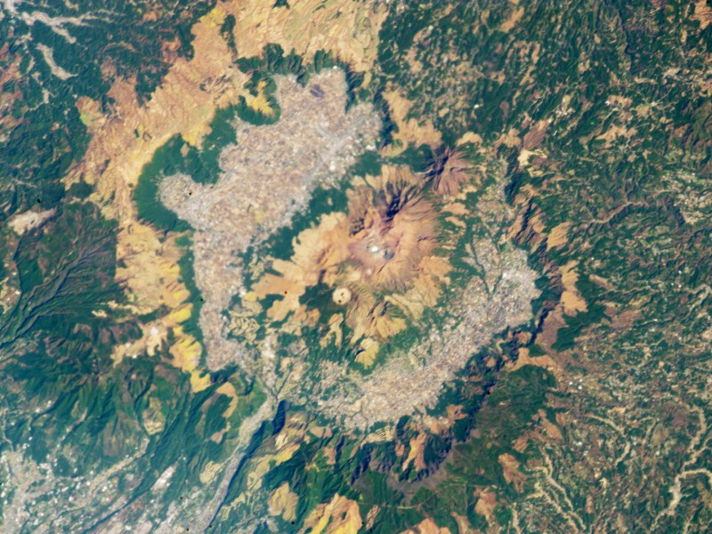
Aso is no single edifice, but a complex of active vents in the center of a large 24 km wide caldera.
Eruptions du volcan Aso: 2021, 2019-2020, 2016, 2014-15, 2011 (May), 2005, 2004, 2003, 1994-95, 1992-93, 1989-91, 1988, 1984-85, 1983, 1981, 1980, 1979-80, 1977-78, 1975-76, 1973-75, 1970-72, 1967-69, 1964-66, 1964, 1963-64, 1963, 1960-62, 1960, 1959, 1957-58, 1957, 1956, 1955, 1954, 1953, 1952(?), 1951, 1950-51, 1949, 1948, 1947, 1946, 1945, 1943-44, 1943, 1942(?), 1940-41, 1938-39, 1937, 1936, 1935, 1934, 1932-33, 1931(?), 1930, 1928-29, 1926-28, 1925, 1923, 1920, 1919, 1918, 1916, 1914, 1911-12, 1910, 1909, 1908, 1907, 1906, 1898-99, 1897, 1894, 1884, 1874, 1872-73, 1856, 1854, 1838, 1837, 1835, 1830-32, 1830, 1829, 1828, 1827-28, 1827, 1826, 1816, 1815, 1814, 1806, 1804, 1781-88, 1772-80, 1765, 1753(?)-54, 1709, 1708(?), 1691, 1683, 1675, 1671, 1668-69, 1668, 1649, 1637, 1631, 1620, 1613, 1612, 1611, 1598-99, 1592, 1587, 1584, 1583, 1582, 1576, 1564, 1563(?), 1562, 1558-59, 1542, 1533, 1522, 1506, 1505, 1485, 1473-74, 1438, 1434, 1390(?) 1388(?), 1387, 1377, 1376, 1375-76, 1369, 1346, 1343, 1340, 1335, 1331-33, 1331, 1324, 1305, 1286, 1281, 1274, 1273, 1272, 1272, 1271, 1269, 1265, 1240, 1239, 1229, 986(?), 867, 864, 796(?), 553
Derniers séismes proches
| Date et l'heure | Mag / Prof. | Distance / Lieux | |||
|---|---|---|---|---|---|
| 30 avril 05:49 (GMT +9) | 0.5 10.1 km | 16 km au nord | Info | ||
| 29 avril 14:55 (GMT +9) | 0.5 8.6 km | 20 km au sud-est | Info | ||
| lundi, 28 avril 2025 GMT (2 séismes) | |||||
| 29 avril 01:09 (GMT +9) | 0.2 14 km | 29 km à l'ouest | Info | ||
| 28 avril 16:10 (GMT +9) | 1.3 86 km | 28 km au sud-est | Info | ||
| samedi, 26 avril 2025 GMT (2 séismes) | |||||
| 27 avril 00:15 (GMT +9) | 0.1 1 km | 28 km au nord-est | Info | ||
| 26 avril 16:07 (GMT +9) | 1.0 12 km | 31 km au sud | Info | ||
| vendredi, 25 avril 2025 GMT (2 séismes) | |||||
| 26 avril 04:09 (GMT +9) | 0.5 7.5 km | 26 km au nord-est | Info | ||
| 25 avril 09:46 (GMT +9) | 0.8 10.1 km | 16 km au nord-est | Info | ||
| dimanche, 20 avril 2025 GMT (1 séisme) | |||||
| 20 avril 15:31 (GMT +9) | 1.8 7.5 km | 14 km au nord | Info | ||
Introduction
The 24-km-wide Aso caldera was formed during four major explosive eruptions from 300,000 to 90,000 years ago. These produced voluminous pyroclastic flows that covered much of Kyushu. The last of these, the Aso-4 eruption, produced more than 600 cu km of airfall tephra and pyroclastic-flow deposits. A group of 17 central cones was constructed in the middle of the caldera, one of which, Naka-dake, is one of Japan's most active volcanoes. It was the location of Japan's first documented historical eruption in 553 AD. The Naka-dake complex has remained active throughout the Holocene. Several other cones have been active during the Holocene, including the Kometsuka scoria cone as recently as about 210 AD. Historical eruptions have largely consisted of basaltic to basaltic-andesite ash emission with periodic strombolian and phreatomagmatic activity. The summit crater of Naka-dake is accessible by toll road and cable car, and is one of Kyushu's most popular tourist destinations.---
Source: GVP Aso volcano information
Aso Volcano Photos

Éruptions volcaniques importantes: volcano Aso
Additionally, there are 15 uncertain or discredited eruptions from Aso volcano.
| Date | Note | VEI | Morts | Dommages | |
|---|---|---|---|---|---|
Obs./docs historiques | 2 | inconnu | |||
Obs./docs historiques | 2 | inconnu | |||
| Nakadake Crater Obs./docs historiques | 3 | inconnu | |||
| 2016 Oct 8 (éruption | Obs./docs historiques | 0 | léger | Infos | |
| Naka-dake Obs./docs historiques | 2 | inconnu | |||
| Naka-dake Obs./docs historiques | 1 | inconnu | |||
| Naka-dake Obs./docs historiques | 1 | inconnu | |||
| Naka-dake Obs./docs historiques | 1 | inconnu | |||
| Naka-dake Obs./docs historiques | 1 | inconnu | |||
| Naka-dake Obs./docs historiques | 1 | inconnu | |||
| Naka-dake Obs./docs historiques | 1 | inconnu | |||
| 1997 Nov 23 (épisode éruptif | Obs./docs historiques | 0 | 2 | inconnu | Infos |
| Naka-dake Obs./docs historiques | 2 | inconnu | |||
| 1994 Mai 29 (éruption | Obs./docs historiques | 1 | 1 | inconnu | Infos |
| Naka-dake Obs./docs historiques | 2 | inconnu | |||
| Naka-dake Obs./docs historiques | 2 | inconnu | |||
| 1990 Oct 19 (éruption | Obs./docs historiques | 2 | 1 | inconnu | Infos |
| 1990 Avr 18 (éruption | Obs./docs historiques | 2 | 1 | inconnu | Infos |
| 1990 Mar 26 (éruption | Obs./docs historiques | 2 | 1 | inconnu | Infos |
| 1989 Fév 12 (éruption | Obs./docs historiques | 0 | 1 | inconnu | Infos |
| Naka-dake Obs./docs historiques | 1 | inconnu | |||
| Naka-dake Obs./docs historiques | 1 | inconnu | |||
| Naka-dake Obs./docs historiques | 1 | inconnu | |||
| Naka-dake Obs./docs historiques | 1 | inconnu | |||
| Naka-dake Obs./docs historiques | 1 | inconnu | |||
| Naka-dake Obs./docs historiques | 2 | inconnu | |||
| 1979 Sep 6 (éruption | Obs./docs historiques | 2 | 3 | inconnu | Infos |
| Naka-dake Obs./docs historiques | 2 | inconnu | |||
| Naka-dake Obs./docs historiques | 1 | inconnu | |||
| Naka-dake Obs./docs historiques | 2 | inconnu | |||
| Naka-dake Obs./docs historiques | 2 | inconnu | |||
| Naka-dake Obs./docs historiques | 1 | inconnu | |||
| Naka-dake Obs./docs historiques | 2 | inconnu | |||
| Naka-dake Obs./docs historiques | 1 | inconnu | |||
| Naka-dake Obs./docs historiques | 2 | inconnu | |||
| Naka-dake Obs./docs historiques | 1 | inconnu | |||
| Naka-dake Obs./docs historiques | 1 | inconnu | |||
| Naka-dake Obs./docs historiques | 2 | inconnu | |||
| Naka-dake Obs./docs historiques | 1 | inconnu | |||
| Naka-dake Obs./docs historiques | 2 | inconnu | |||
| 1957 Oct (éruption | Obs./docs historiques | 2 | 12 | inconnu | Infos |
| Naka-dake Obs./docs historiques | 1 | inconnu | |||
| Naka-dake Obs./docs historiques | 1 | inconnu | |||
| Naka-dake Obs./docs historiques | 2 | inconnu | |||
| Naka-dake Obs./docs historiques | 2 | inconnu | |||
| Naka-dake Obs./docs historiques | 1 | inconnu | |||
| Naka-dake Obs./docs historiques | 1 | inconnu | |||
| Naka-dake Obs./docs historiques | 1 | inconnu | |||
| Naka-dake Obs./docs historiques | 2 | inconnu | |||
| 1953 Avr 27 (éruption | Obs./docs historiques | 2 | 6 | inconnu | Infos |
?? | Éruption incertaine | ? | inconnu | ||
| Naka-dake Obs./docs historiques | 2 | inconnu | |||
| Naka-dake Obs./docs historiques | 2 | inconnu | |||
| Naka-dake Obs./docs historiques | 2 | inconnu | |||
| Naka-dake Obs./docs historiques | 1 | inconnu | |||
| Naka-dake Obs./docs historiques | 2 | inconnu | |||
| Naka-dake Obs./docs historiques | 2 | inconnu | |||
| Naka-dake Obs./docs historiques | 2 | inconnu | |||
| Naka-dake Obs./docs historiques | 2 | inconnu | |||
| Naka-dake Obs./docs historiques | 2 | inconnu | |||
| Naka-dake Obs./docs historiques | 2 | inconnu | |||
?? | Éruption incertaine | 1? | inconnu | ||
| Naka-dake Obs./docs historiques | 2 | inconnu | |||
| Naka-dake Obs./docs historiques | 2 | inconnu | |||
| Naka-dake Obs./docs historiques | 2 | inconnu | |||
| Naka-dake Obs./docs historiques | 2 | inconnu | |||
| Naka-dake Obs./docs historiques | 2 | inconnu | |||
| Naka-dake Obs./docs historiques | 2 | inconnu | |||
| Naka-dake Obs./docs historiques | 2 | inconnu | |||
| Naka-dake Obs./docs historiques | 2 | inconnu | |||
| Naka-dake Obs./docs historiques | 2 | inconnu | |||
| Naka-dake Obs./docs historiques | 2 | inconnu | |||
| Naka-dake Obs./docs historiques | 2 | inconnu | |||
| Naka-dake Obs./docs historiques | 2 | inconnu | |||
| Naka-dake Obs./docs historiques | 2 | inconnu | |||
| Naka-dake Obs./docs historiques | 2 | inconnu | |||
| Naka-dake Obs./docs historiques | 2 | inconnu | |||
| Naka-dake Obs./docs historiques | 3 | inconnu | |||
Eruptions du volcan Aso
2 tourists were killed by volcanic gas 100 m south of the rim of Crater 1 on 23 November 1997. Since 1980, more than 70 people have been injured by volcanic gases at Aso and have been hospitalized.
3 people were killed and 11 injured by ballistic blocks ejected by an explosion that occurred at about 1pm local time on 6 September 1979.
Aso Volcano FAQ
+When was the last eruption of Aso volcano?
The last confirmed eruption of Aso occurred in 2021.
+How often does Aso volcano erupt?
Since 864 AD, Aso volcano has had at least 159 historically documented eruptions. This means that it erupts on average every 7.3 years.
Many eruptions of Aso have lasted more than one year. In total, the volcano has been in eruption during 193 out of 1161 years until now. In other words, Aso has been active at least one in 6 years on average. Note that this value is likely an underestimate, because the known history of eruptions from Aso is likely incomplete, especially further back in time.
+How active is Aso volcano at present?
Aso volcano is extremely active: Since 1900, it has been near-continuously active, showing eruptive activity during 89 years out of 126 as of now. The last eruption was in 2021 and ended 4 years ago.
+When was the largest eruption of Aso volcano?
The largest eruption of Aso volcano in historic times occurred in 2016. It ranks as a "vulcanian" eruption with a magnitude 3 on the VEI (Volcanic Explosivity Index) scale.
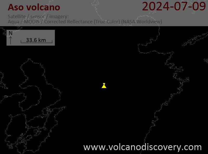
Dernières images satellite

Aso Volcan Cartes


