Chirpoi Volcano
Updated: Dec 13, 2024 15:12 GMT -
caldera 742 m / 2,434 ft
Kurile Islands, Russia, 46.53°N / 150.88°E
Current status: normal or dormant (1 out of 5)
Kurile Islands, Russia, 46.53°N / 150.88°E
Current status: normal or dormant (1 out of 5)
Last update: 15 Dec 2021 (Smithsonian / USGS Weekly Volcanic Activity Report)
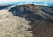
Chirpoi volcano forms a small island in the central Kurile Islands, Russia. It has a 8-9 km wide partially submerged caldera with several volcanic centers inside the caldera, including active Snow and Cerny volcanoes. The southern caldera rim emerges again on nearby Brat Chirpoey Island 2.5 km SE of Chirpoi.
[smaller] [larger]
Chirpoi volcano eruptions: 2015 (S), 2014 (S), 2012 (S), 1982 (S), 1960 (S), 1879 (S), 1857 (C), 1854 (S or C), 1811 (S), 1790 (S), 1712 (C)
--
S: Snow volcano / C: Cerny volcano
Latest nearby earthquakes
Background
Only 2 volcanoes on Chirpoi Island have been historically active: The symmetrical Cherny volcano which forms the highest peak erupted 2 times. The second, younger and more active volcano is Snow. Snow volcano formed between 1770 and 1810 and is composed almost entirely of lava flows, many of which have reached the sea on the southern coast.There are no historical eruptions on Brat Chirpoev, but its youthful morphology suggests recent strombolian activity.
(Source: GVP / Smithsonian Chirpoi volcano information)
Latest satellite images
Chirpoi Volcano Maps
Below is a selection of maps showing the location and surroundings of the volcano at various resolutions based on aerial-imagery / terrain maps. Feel free to use them for non-commercial purposes on your blog or website as long as you credit them with a link back to this page (click to copy it).
Satellite/aerial-type map of Chirpoi volcano (world scale)
Terrain-type map of Chirpoi volcano (world scale)
Satellite/aerial-type map of Chirpoi volcano (region scale large)
Terrain-type map of Chirpoi volcano (region scale large)
Satellite/aerial-type map of Chirpoi volcano (region scale medium)
Terrain-type map of Chirpoi volcano (region scale medium)
Satellite/aerial-type map of Chirpoi volcano (region scale small)
Terrain-type map of Chirpoi volcano (region scale small)
Satellite/aerial-type map of Chirpoi volcano (local scale large)
Terrain-type map of Chirpoi volcano (local scale large)
Satellite/aerial-type map of Chirpoi volcano (local scale medium)
Terrain-type map of Chirpoi volcano (local scale medium)
Satellite/aerial-type map of Chirpoi volcano (local scale small)
Terrain-type map of Chirpoi volcano (local scale small)
Satellite/aerial-type map of Chirpoi volcano (scale of 10s of km)
Terrain-type map of Chirpoi volcano (scale of 10s of km)
Satellite/aerial-type map of Chirpoi volcano (scale of 20-40 km)
Terrain-type map of Chirpoi volcano (scale of 20-40 km)
Satellite/aerial-type map of Chirpoi volcano (scale of approx. 10-20 km)
Terrain-type map of Chirpoi volcano (scale of approx. 10-20 km)
Satellite/aerial-type map of Chirpoi volcano (scale of 5-10 km)
Satellite/aerial-type map of Chirpoi volcano (scale of few kilometers)