Contact | RSS | EN | DE | EL | ES | FR | IT | RU

Ngauruhoe Volcano

Updated: 28 avril. 2024 00:51 GMT -
Stratovolcano 1978 m (6,489 ft)
Île du Nord (New Zealand), -39.13°S / 175.64°E
Condition actuelle: normal / en sommeil (1 sur 5)
Last update: 24 avril 2015
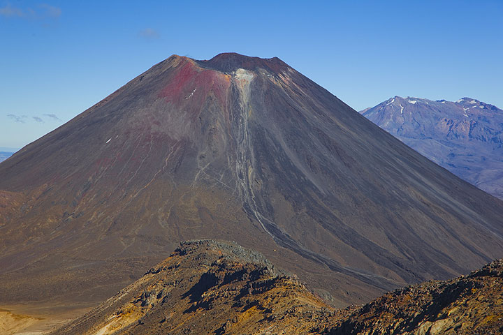
Ngauruhoe volcano seen from Tongariro; Ruhapehu volcano in the background.

Ngauruhoe (pronouned "Nauruhó"), a steep 600 m tall stratovolcano 17 km NNE of Ruhapehu volcano, is the main vent of Tongariro volcano and one of New Zealand's most active volcanoes. Its last eruptive phase in 1975-77 produced violent ash explosions, lava fountains and pyroclastic flows. In its recent past, Ngauruhoe has been erupting around every 10 years and the time lapsed since then makes this the longest repose interval known in its recorded history.

[smaller] [larger]
Style éruptif tipique: Explosive
Eruptions du volcan Ngauruhoe: 1975-77, 1972, 1968-69, 1962, 1958-59, 1956, 1948-54, 1939-40, 1937, 1934, 1931, 1924-28, 1917, 1913-14, 1909-10, 1904-07, 1897-98, 1892, 1883, 1881, 1878, 1875, 1869-70, 1862-64, 1857, 1844, 1841, 1839, 550 BC ± 200

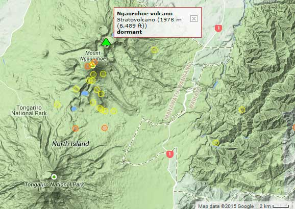
Derniers séismes proches

HeureMag. / ProfondeurDistance / Lieu
26 avril 14:06 (Auckland)
2.0

4.4 km
3.5 km au nord-est New Zealand
Info
26 avril 14:05 (Auckland)
1.7

3.9 km
3.1 km au nord-est New Zealand
Info
jeudi, 25 avril 2024 GMT (1 séisme)
26 avril 08:03 (Auckland)
1.9

82 km
27 km au nord New Zealand
Info
mardi, 23 avril 2024 GMT (1 séisme)
23 avril 22:49 (Auckland)
1.6

3.7 km
New Zealand
Info
samedi, 20 avril 2024 GMT (1 séisme)
20 avril 18:11 (Auckland)
1.5

5.7 km
New Zealand
Info
mercredi, 17 avril 2024 GMT (1 séisme)
18 avril 10:51 (Auckland)
1.4

19 km
New Zealand
Info

Introduction

Ngauruhoe is the youngest and most active cone of the large Tongariro volcanic complex, and forms today its highest peak. Ngauruhoe started to grow about 2500 years ago and has been frequently active in historic times.

Eruptions du volcan Ngauruhoe


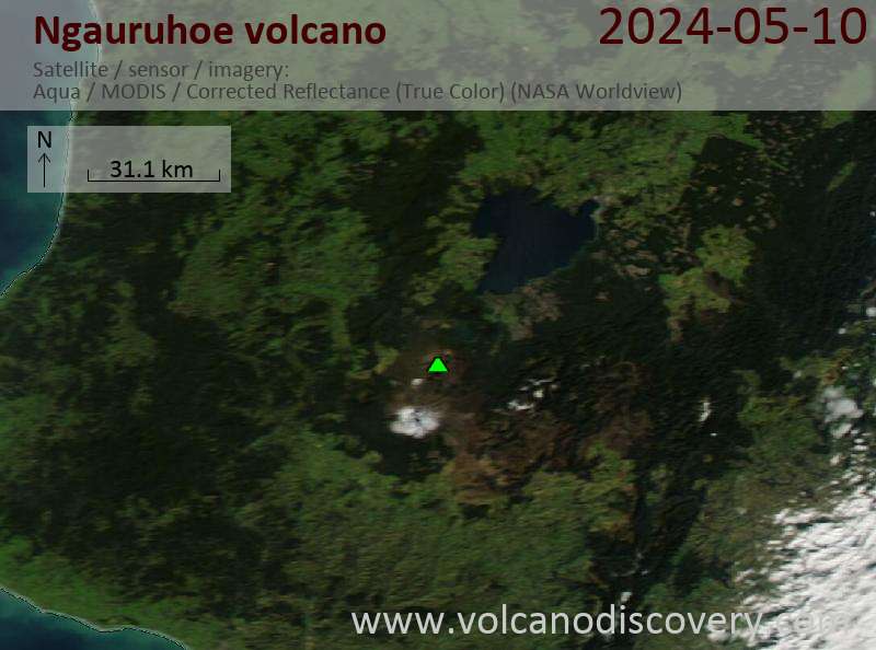
Latest satellite images

Ngauruhoe satellite image sat1Ngauruhoe satellite image sat2
Actualités
ven., 24 avril 2015, 22:32

Ngauruhoe volcano (New Zealand): alert level lowered back to normal

The alert level was lowered back to the lowest level green, after signs of unrest at the volcano gradually had declined during the past weeks. ... Read all
lun., 23 mars 2015, 08:43

Ngauruhoe volcano (New Zealand): minor volcanic unrest

Earthquakes (yellow and red circles) near Ngauruhoe during the past 14 days
New Zealand's GNS Science reports an increase in earthquakes under the volcano, interpreted as weak signs of volcanic unrest. The Volcanic Alert Level was raised to level 1 (minor volcanic unrest), but no eruption is expected in the near future. ... Read all

Sur cette page:

Découvrez notre app gratuite !
Volcanoes & Earthquakes - new app for Android
Android | Version iOS

Plus sur VolcanoDiscovery

Why is there advertising on this site?

Support us - Help us upgrade our services!

We truly love working to bring you the latest volcano and earthquake data from around the world. Maintaining our website and our free apps does require, however, considerable time and resources.
We need financing to increase hard- and software capacity as well as support our editor team. We're aiming to achieve uninterrupted service wherever an earthquake or volcano eruption unfolds, and your donations can make it happen! Every donation will be highly appreciated. If you find the information useful and would like to support our team in integrating further features, write great content, and in upgrading our soft- and hardware, please make a donation (PayPal or Online credit card payment).

Planned features:Thanks to your past donations, these features have been added recently:
Download and Upgrade the Volcanoes & Earthquakes app to get one of the fastest seismic and volcano alerts online:
Android | IOS
Thank you!
Copyright: VolcanoDiscovery ou autres sources indiquées.
Utilisation des documents: Les textes, les images et les vidéos de ce site internet sont protégées par copyright. Toute reproduction et tout usage sans accord préalable ne sont pas autorisés. Si vous désirez acquérir pour certains documents (photos, vidéos, textes ou autres) le droit de reproduction, d'édition et, plus généralement, de toute utilisation destinée à un usage public, qu'elle soit commerciale ou pas, vous êtes priés de nous contacter.
Volcanoes & Earthquakes
VolcanoDiscovery Home
Volcans | Séismes | Photos | Actualités | App
Adventure & Study Travel
Tours to Volcanoes and Volcanic Areas: walking tours, photo tours, study tours
Voyages |
Get our newsletter!
Company info
Contact | Mentions légales | Terms & conditions
Follow us
Follow us on facebook Follow us on Instagram Follow us on Twitter Visit our Youtube channel
EN | DE | EL | ES | FR | IT | RU
VolcanoDiscovery GmbH, Germany, Reg. nr.: HRB 103744, EU Tax Id: DE 297 465 123 owned and created by
Dr. Tom Pfeiffer, volcanologist, volcano photographer, tour organizer member of
IAVCEI
IAVCEI
Vulkanologische Gesellschaft
Volcanological Society
Ecotourism Greece
Ecotourism Greece
RUV insurance
Insured by R+V
VolcanoDiscovery © 2004- All Rights Reserved | Privacy - Changer Préférences