Volcano list
Aitutaki
(Shield 124 m / 407 ft)Alderman Islands
(Lava dome(s) unknown)Brothers
(Submarine volcano -1350 m / - 4,429 ft)Clark
(Submarine volcano -860 m / - 2,821 ft)Cole
(Submarine -2400 m / -7874 ft)Giljanes
(Submarine -700 m / -2297 ft)Haungaroa
(Submarine -660 m / -2165 ft)Hautere
(Stratovolcano 330 m / 1083 ft)Healy
(Submarine volcano 980 m / 3,215 ft)Kaimai
(Volcanic field 564 m / 1850 ft)Kaitake
(Stratovolcano 684 m / 2244 ft)Kakepuku
(Lava cone(s) 450 m / 1476 ft)Kapenga
(Caldera(s) 840 m / 2756 ft)Karioi
(Stratovolcano 756 m / 2480 ft)Kibblewhite
(Submarine -1000 m / -3281 ft)Kuiwai
(Submarine -560 m / -1837 ft)Little Barrier
(Stratovolcano 722 m / 2369 ft)Mangakino
(Caldera 1165 m / 3822 ft)Maroa
(Calderas 1156 m / 3,793 ft)Mayor Island
(Shield volcano 355 m / 1,165 ft)Mercury Islands
(Volcanic field 230 m / 755 ft)Mokohinau Islands
(Volcanic field 134 m / 440 ft)Moutohora Island
(Complex 354 m / 1161 ft)Ngatoroirangi
(Submarine -340 m / -1115 ft)Northern Tongariro Group
(Stratovolcano(es) 1327 m / 4354 ft)Okataina (Tarawera)
(Lava domes 1111 m / 3,645 ft)Oliver-Speight
(Submarine -1840 m / -6037 ft)Pirongia
(Stratovolcano 959 m / 3146 ft)Pouakai
(Stratovolcano 1399 m / 4590 ft)Rapuhia
(Submarine -650 m / -2133 ft)Rarotonga
(Shield 639 m / 2096 ft)Reporoa
(Caldera 592 m / 1,942 ft)Rotorua
(Caldera 757 m / 2,484 ft)Rumble I
(Submarine -1100 m / -3609 ft)Rumble II East
(Submarine -1150 m / -3773 ft)Rumble II West
(Submarine volcano 1200 m / 3,937 ft)Rumble III
(Submarine volcano -220 m / - 722 ft)Rumble IV
(Submarine volcano 500 m / 1,640 ft)Rumble V
(Submarine volcano 400? m / 1,312 ft)Rungapapa Knoll
(Submarine unknown)Silent II East
(Submarine -1250 m / -4101 ft)Silent II West
(Submarine -780 m / -2559 ft)Solander Island
(Stratovolcano 300 m / 984 ft)Sonne
(Submarine -995 m / -3264 ft)South Auckland
(Shield(s) 314 m / 1030 ft)South Coromandel Peninsula
(Volcanic field 795 m / 2608 ft)Tangaroa
(Submarine volcano 600 m / 1,968 ft)Taupo
(Caldera 760 m / 2,493 ft)Thompson
(Submarine -1250 m / -4101 ft)Whale Island
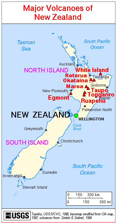
(Complex volcano 354 m / 1,161 ft)White Island
(stratovolcano 321 m / 1,053 ft)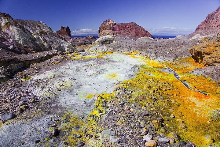
Inside the crater of White Island volcano