Kontakt | RSS | EN | DE | EL | ES | FR | IT | RU

Volcanoes of Africa & Arabia

[kleiner] [größer]

Algerien (7 Vulkane)

Atakor Volcanic Field | In Ezzane Volcanic Field | In Teria Volcanic Field | Manzaz Volcanic Field | Nemours-Nedroma | Tafna Beni Saf | Tahalra Volcanic Field

Kamerun (6 Vulkane)

Cameroon | Kumba Volcanic Field | Manengouba | Ngaoundere Plateau | Oku Volcanic Field | Tombel Graben

Tschad (6 Vulkane)

Emi Koussi | Tarso Ahon | Tarso Emi Chi | Tarso Tôh | Tarso Toussidé | Tarso Voon

Demokratische Republik Kongo (DRC) (6 Vulkane)

Karisimbi | May-ya-moto | Nyamuragira | Nyiragongo | Tshibinda | Visoke

Dschibuti (2 Vulkane)

Ardoukôba | Babba'Olou

Äquatorialguinea (3 Vulkane)

San Carlos | San Joaquin | Santa Isabel

Eritrea (8 Vulkane)

Alid | Assab Volcanic Field | Dubbi | Gufa | Jalua | Mabda | Mallahle | Nabro

Äthiopien (77 Vulkane)

Adwa | Afderà | Alayta | Ale Bagu | Ali Mela | Alu | Alutu | Asavyo | Asgura | Ayelu | Badi | Beru | Bilate River Field | Bishoftu Volcanic Field | Boina | Bora-Bericcio | Borale Ale | Borawli | Boset-Bericha | Butajiri-Silti Field | Ch'Ilalo | Chew Bahir | Chiracha | Corbetti Caldera | Dabbahu | Dabbayra | Dalafilla | Dalaha'ale | Dallol | Dama Ali | Data Gabalti | Dawa Ale-Quarry | Didolli | Dofen | Duguna | East Zway | Egersuwa | Ela | Erta Ale | Fantale | Finini | Gabillema | Gad Elu | Gada Ale | Gademota Caldera | Gedamsa | Groppo | Hayli Gubbi | Hertali | Hobitcha Caldera | Katahelu | Kone | Korath Range | Kurub | Liado Hayk | Ma Alalta | Manda Gargori | Manda Hararo | Manda-Inakir | Mat Ala | Mega Basalt Field | Mousa Alli | O'a Caldera | Oyma | Sodore | Sork Ale | Tat Ali | Tepi | Tosa Sucha | Tullu Moje | Undurer | Unnamed 8.07°N / 39.07°E | Unnamed 8.62°N / 38.95°E | Unnamed 8.70/39.63 | Unnamed 8.7°N / 39.63°E | Yangudi | Zikwala

Kenia (31 Vulkane)

Asie | Bogoria | Central Island | Chyulu Hills | Elmenteita Badlands | Emuruangogolak | Homa Mountain | Huri | Kilombe Caldera | Korosi | Kulal | Lenderut | Longonot | Marsabit | Menengai | Namarunu | North Island | Nyambeni Hills | Ol Doinyo Eburru | Ol Doinyo Nyokie | Ol Kokwe | Olkaria | Paka | Porr | Segererua Plateau | Shombole | Silali | South Island | Sultan Hamud-Simba | Suswa | The Barrier

Libyen (3 Vulkane)

Haruj | Wau-en-Namus | Waw an Namous

Marokko (7 Vulkane)

Azrou Volcanic Field | Berguent Volcanic Field | Chott Tigri Volcanic Field | Mrit-Ment Volcanic Field | Oujda Volcanic Field | Oulmes Volcanic Field | Rekkame Volcanic Field

Nigeria (2 Vulkane)

Biu Plateau | Jos Plateau

Ruanda (1 Vulkan)

Sabinyo

São Tomé und Príncipe (1 Vulkan)

Sao Tome

Saudi-Arabien (14 Vulkane)

Al Harrah | Harrat 'Uwayrid | Harrat al Birk | Harrat ar Rahah | Harrat Ash Shaam | Harrat Hutaymah | Harrat Ithnayn | Harrat Khaybar | Harrat Kishb | Harrat Lunayyir | Harrat Rahat | Jabal Baqarah | Jabal Yar | Jibal al Haylah

Senegal (1 Vulkan)

Cap-Vert

Sudan (5 Vulkane)

Bayuda Volcanic Field | Jebel Marra | Jebel Umm Arafieb | Kutum Volcanic Field | Meidob Volcanic Field

Tansania (23 Vulkane)

Burko | Embagai | Gelai | Hanang | Igwisi Hills | Izumbwe-Mpoli | Katete | Kerimasi | Ketumbeine | Kilimanjaro | Kwaraha | Kyejo | Loolmalasin | Meru | Ngorongoro | Ngozi | Ol Doinyo Lengai | Olmoti | Rungwe | Sadiman | SW Usangu Basin | Tukuyu | Usangu Scarp Basalt

Uganda (9 Vulkane)

Bufumbira | Bunyaruguru | Fort Portal | Katunga | Katwe-Kikorongo | Kyatwa | Muhavura | Sabinyo

Yemen (11 Vulkane)

Bir Borhut | Harra es-Sawâd | Harra of Arhab | Harra of Bal Haf | Harras of Dhamar | Jabal el-Marha | Jabal Haylan | Hanish | Jebel al-Tair | Jebel Zubair | Zukur
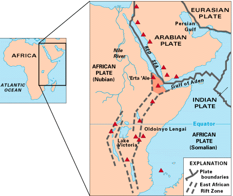
Karte von Ostafrika, die die aktiven Vulkane zeigt (rote Dreiecke). Zusätzlich das "Afar-Dreieck", wo drei tektonische Platten auseinandertriften: Die Arabische Platte und die zwei restlichen Teile der Afrikanischen Platte (die Nubische und die Somalische Platte). Sie reissen am Ostafrikanischen Rift Valley auseinander


Nachrichten

Fr, 10. Mai 2024, 12:39

Erta Ale volcano (Danakil depression, Ethiopia) field report: yet another lava sequence in northern pit crater

Pahoehoe-type basaltic lava flow in the northern pit crater (image: EnkuMulugeta/VolcanoDiscovery Ethiopia)
The activity has been picking up at the volcano again over the past few days. ... Read all
Do, 25. Apr 2024, 03:20

Erta Ale volcano (Danakil depression, Ethiopia) field report: new hornito has triggered lava overflow towards northern caldera

The lava oozes out from the newly formed hornito, located somewhere in between the southern and northern pit crater (image: EnkuMulugeta/VolcanoDiscovery Ethiopia)
We were given first-hand information from our expedition leader, geologist and local guide, Enku Mulugeta from VolcanoDiscovery Ethiopia, about an increased activity at the volcano over the past three days. ... Read all
  • Expeditionen in Afrika

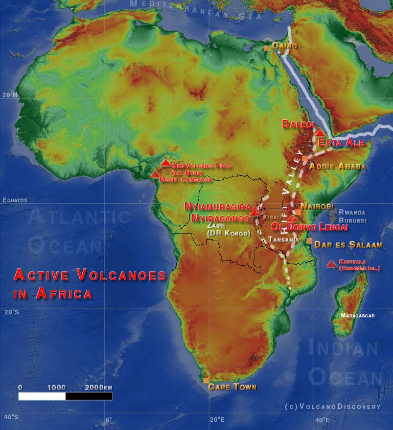
Karte der wichtigsten Vulkane in Afrika
Volcanoes in Africa
Adapted from: Simpkin and Siebert, 1994, Volcanoes of the World:
Africa is the only region other than the Mediterranean with an historically dated B.C. eruption (at Mount Cameroon, observed by a passing Carthaginian navigator in the 5th century B.C.). By the 15th centuray A.D., however, when Portuguese exploration of Africa had begun and Vasco de Gama sailed to India via the Cape of Good Hope, only 2 more eruptions had been recorded, both from Ethiopia. In the next 3 and two-thirds centuries, another 20 some eruptions were recorded, but the main historical record of the continent began with the opening of the Suez Canal at the end of 1869, and the heyday of African exploration that followed.
Most African volcanoes result from hotspots, the rifting in East Africa, or a combination of the two. The East African rift, one of the world's most dramatic extensional structures, has produced the continent's highest and lowest volcanoes, ranging from the massive Kilimanjaro to vents in Ethiopia's Danakil Depression that lie below sea level.
Two neighboring volcanoes in Zaire's (today's Democratic Republic of the Congo) Virunga National Park, Nyamuragira and Nyiragongo, are responsible for nearly two-fifths of Africa's historical eruptions.

Warum gibt es Werbung auf dieser Seite?
Sources: VolcanoDiscovery / VolcanoAdventures and other sources as noted.
Use of material: Most text and images on our websites are owned by us. Re-use is generally not permitted without authorization. Contact us for licensing rights.
Volcanoes & Earthquakes
VolcanoDiscovery Home
Vulkane | Erdbeben | Fotos | News | App
Adventure & Study Travel
Reisen zu Vulkanen und Vulkangebieten: Wanderreisen, Studienreisen, Fotoreisen
Tours & Dates | FAQ | About us
Get our newsletter!
Company info
Kontakt | Impressum | AGB
Follow us
Follow us on facebook Follow us on Instagram Follow us on Twitter Visit our Youtube channel
EN | DE | EL | ES | FR | IT | RU
VolcanoDiscovery GmbH, Germany, Reg. nr.: HRB 103744, EU Tax Id: DE 297 465 123 owned and created by
Dr. Tom Pfeiffer, volcanologist, volcano photographer, tour organizer member of
IAVCEI
IAVCEI
Vulkanologische Gesellschaft
Volcanological Society
Ecotourism Greece
Ecotourism Greece
RUV insurance
Insured by R+V
VolcanoDiscovery © 2004- All Rights Reserved | Datenschutz - Cookie Einstellungen