Colli Albani Volcano
Updated: Aug 5, 2025 21:48 GMT -
stratovolcano, caldera
Italy, 41.75°N / 12.71°E 
Summit height: 950 m
Current status: normal or dormant (1 out of 5)
Last update: 14 Mar 2022
The Colli Albani or Monte Albano (or Alban Hills) complex immediately SE of Rome contains a large Pleistocene stratovolcano with a 10 x 12 km wide caldera.
[smaller] [larger]
Colli Albani volcano eruptions: unknown
Latest nearby earthquakes
| Date and Time | Mag / Depth | Distance / Location | |||
|---|---|---|---|---|---|
Background
The Colli Albani caldera was formed during an eruptive period with six major explosive eruptions producing at least 280 cu km of ejecta between about 560,000 and 350,000 years ago. Subsequent eruptions occurred from a new 5-km-wide central cone and from many phreatomagmatic craters and cones within the Artemisio-Tuscolana caldera and on its outer flanks. The post-caldera eruptions have buried the western side of the caldera rim.The largest of the post-caldera craters is Lake Albano, a 4 x 2.5 km wide maar constructed at the WSW margin of the caldera in 5 stages dating back to about 45,000 years ago. Eruptive products of the 3rd stage were dated at 26,000 yrs Before Present (BP). The 4th and 5th stages were not dated directly, but sediment-core gaps at 16,000 and 7500 yrs BP may correspond to these eruptions (Villa et al., 1999). Reported historical eruptions during the Roman period are uncertain, but seismic swarms of up to two years duration have been recorded since Roman times.
Source: Smithsonian GVP
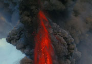
Colli Albani Volcano Photos
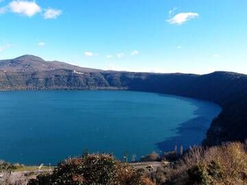
The maar of Lago Albano is one of the remains of the ancient Latium volcano, Castelgandolfo, Colli Albani, Italy (Photo: Janka)
Significant volcanic eruptions: Colli Albani volcano
In the past 10,000 years, Colli Albani has had only one confirmed historic eruption ###WHEN1###|only one confirmed historic eruption ###WHEN1### and one ###WHEN2### inferred from geological evidence|only one confirmed historic eruption ###WHEN1###, but at least ###NUM_INFERRED### eruptions can be inferred from geological evidence|at least ###NUM_CONFIRMED### confirmed eruptions, all documented by historical records or observations|at least ###NUM_CONFIRMED### confirmed volcanic eruptions, out of which ###NUM_HISTORIC### are documented by historical records, while the others can be inferred from geological evidence.
No historic eruptions are known from Colli Albani volcano, but at least one eruption ###WHEN2### can be inferred from geological evidence|evidence from at least ###NUM_CONFIRMED### eruptions during the past 10,000 years can be found in the geological record.
There are only 3 uncertain or discredited eruptions from Colli Albani volcano during the past 10,000 years.
The table below lists all known eruptions (date in bold face) of Colli Albani volcano in historic times and during the past 10,000 years. Updates on the most recent volcanic activity of Colli Albani can be found on the news page of Colli Albani volcano.
| Date | Note | VEI | Deaths | Damage | ||
|---|---|---|---|---|---|---|
Discredited Eruption | ||||||
Discredited Eruption | ||||||
?? | Uncertain Eruption | ? | ||||
Remark:
Our list of volcanic eruptions closely follows the database of eruptions of the Smithsonian's Global Volcanism Project (GVP), the internationally most recognized data source for volcanic eruptions, but also includes significant eruptive episodes or related volcano events. "Volcanic eruptions" are usually to be understood as sequences of individual eruptive episodes that can follow each other, or even overlap (if several vents are involved), and can last many years, decades or even longer. For example, the current activity of Stromboli volcano is understood as a single eruption that has been ongoing since 1934.
Sources: NOAA National Centers for Environmental Information (NCEI), Global Significant Volcanic Eruptions Database. doi:10.7289/V5TD9V7K | Global Volcanism Project / Smithsonian Institution
Latest satellite images

Colli Albani Volcano Maps
Below is a selection of maps showing the location and surroundings of the volcano at various resolutions based on aerial-imagery / terrain maps. Feel free to use them for non-commercial purposes on your blog or website as long as you credit them with a link back to this page (click to copy it).

Satellite/aerial-type map of Colli Albani volcano (world scale)

Terrain-type map of Colli Albani volcano (world scale)

Satellite/aerial-type map of Colli Albani volcano (region scale large)

Terrain-type map of Colli Albani volcano (region scale large)

Satellite/aerial-type map of Colli Albani volcano (region scale medium)

Terrain-type map of Colli Albani volcano (region scale medium)

Satellite/aerial-type map of Colli Albani volcano (region scale small)

Terrain-type map of Colli Albani volcano (region scale small)

Satellite/aerial-type map of Colli Albani volcano (local scale large)

Terrain-type map of Colli Albani volcano (local scale large)

Satellite/aerial-type map of Colli Albani volcano (local scale medium)

Terrain-type map of Colli Albani volcano (local scale medium)

Satellite/aerial-type map of Colli Albani volcano (local scale small)

Terrain-type map of Colli Albani volcano (local scale small)

Satellite/aerial-type map of Colli Albani volcano (scale of 10s of km)

Terrain-type map of Colli Albani volcano (scale of 10s of km)

Satellite/aerial-type map of Colli Albani volcano (scale of 20-40 km)

Terrain-type map of Colli Albani volcano (scale of 20-40 km)

Satellite/aerial-type map of Colli Albani volcano (scale of approx. 10-20 km)

Terrain-type map of Colli Albani volcano (scale of approx. 10-20 km)

Satellite/aerial-type map of Colli Albani volcano (scale of 5-10 km)

Satellite/aerial-type map of Colli Albani volcano (scale of few kilometers)