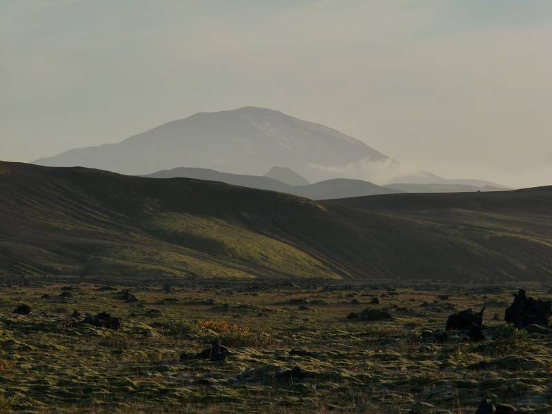
| RSS | EN | DE | EL | ES | FR | IT | RU

Hekla Volcano

Updated: May 1, 2025 15:41 GMT -
stratovolcano
Iceland, 63.99°N / -19.67°W
Summit height: 1491 m (4,892 ft)
Current status: normal or dormant (1 out of 5)
Last update: 15 Dec 2021
Hekla in eruption in March 2000 with the large black lava flow in the foreground from that eruption.

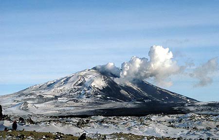
1491-m-high Hekla is one of Iceland's most prominent, most known and active volcanoes. It has frequent eruptions that start with an explosive onset producing eruption plumes, then lava fountains and culminate in large lava flows. Most of the volcano's flanks are covered by extensive lava flows from historical eruptions, dating back to 1104 AD.

[smaller] [larger]
Typical eruption style: Explosive and effusive.
Hekla volcano eruptions: 1104 (large, Plinian eruption), 1158, 1206, 1222, 1300, 1341, 1389, 1440(?), 1510, 1554, 1597, 1636-37, 1693, 1725, 1766-68, 1845-46, 1878, 1913, 1947-48, 1970, 1980, 1981, 1991, 2000

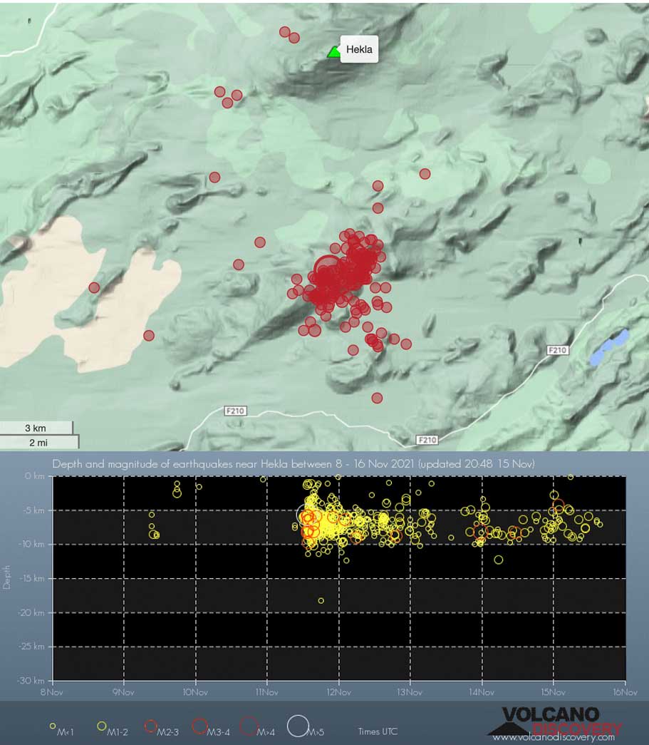
Latest nearby earthquakes

Date and TimeMag / DepthDistance / Location
May 1, 10:56 am (Reykjavik)
0.4

0.2 km
1.2 km (0.7 mi) to the W Iceland: 1.2 km W of Hekla Info
Wednesday, April 30, 2025 GMT (3 quakes)
Apr 30, 08:04 pm (Universal Time)
1.2

2.5 km
19 km (12 mi) to the E 10.4 km NNW of Álftavatn Info
Apr 30, 08:00 pm (Reykjavik)
0.5

3.2 km
19 km (12 mi) to the E Iceland: 9.5 km NNW of Álftavatn Info
Apr 30, 07:38 pm (Reykjavik)
0.7

2.2 km
19 km (12 mi) to the E Iceland: 10.2 km NNW of Álftavatn Info
Tuesday, April 29, 2025 GMT (2 quakes)
Apr 29, 01:43 pm (Universal Time)
0.7

0.9 km
18 km (11 mi) to the E 10.1 km NNW of Álftavatn Info
Apr 29, 01:42 pm (Universal Time)
0.6

2.7 km
18 km (11 mi) to the E 10.5 km NNW of Álftavatn Info
Monday, April 28, 2025 GMT (1 quake)
Apr 28, 09:52 pm (Universal Time)
0.6

1.5 km
21 km (13 mi) to the E 10.1 km N of Álftavatn Info
Sunday, April 27, 2025 GMT (1 quake)
Apr 27, 06:41 pm (Universal Time)
1.2

7.8 km
12 km (7.2 mi) to the SW 9.9 km W of Vatnafjöll Info
Monday, April 21, 2025 GMT (3 quakes)
Apr 21, 05:55 pm (Universal Time)
1.3

1.4 km
29 km (18 mi) to the W 4.0 km NNE of Árnes Info

Background

Hekla is located near the southern end of the eastern rift zone. It sits on a rift-transform junction, and has produced basaltic andesites, in contrast to the tholeiitic basalts typical of Icelandic rift zone volcanoes. Hekla's tephras are generally rich in flourine, which is very hazardous to grazing animals.
The elongated shape of the volcano is caused by a 5.5-km-long fissure, Heklugjá, that cuts across the volcano and is often active along its full length during major eruptions. Repeated such eruptions, oblique to most rifting structures in the eastern volcanic zone, have created Hekla's elongated ENE-WSW profile.
Frequent large explosive eruptions during historical times have deposited tephra throughout Iceland and provide important time markers that can be used to date eruptions from other volcanoes in Iceland.

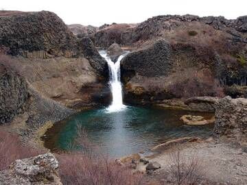
Hekla Volcano Photos

Significant volcanic eruptions: Hekla volcano

In the past 10,000 years, Hekla has had at least 65 confirmed volcanic eruptions, out of which 23 are documented by historical records, while the others can be inferred from geological evidence.
The table below lists all known eruptions (date in bold face) of Hekla volcano since around 1000 AD. Updates on the most recent volcanic activity of Hekla can be found on the news page of Hekla volcano.
DateNoteVEIDeathsDamage
2000 Feb 26 - Mar 8SW flank
Historical obs./docs.
3
1991 Jan 17 - Mar 11Summit, SW, SE & NE flank fissures
Historical obs./docs.
3
1981 Apr 9 - Apr 16Summit and north flank (900 and 740 m)
Historical obs./docs.
2
1980 Aug 17 - Aug 20Summit, SW and NE flanks
Historical obs./docs.
3
1980 Aug 17
(eruption 1980 Aug 17 - Aug 20)
Historical obs./docs.
3
light
Info
1970 May 5 - Jul 5Sudurgigar, Hlidargigar, Oldugigar
Historical obs./docs.
3
1970 May 5
(eruption 1970 May 5 - Jul 5)
Historical obs./docs.
3
light
Info
1947 Mar 29 - 1948 Apr 21Hraungigur, Axlargigur, Toppgigur
Historical obs./docs.
4
1947 Nov 2
(eruption 1947 Mar 29 - 1948 Apr 21)
Historical obs./docs.
41
Info
1913 Apr 25 - May 18E & NE of Hekla (Mundafit, Lambafit)
Historical obs./docs.
2
1878 Feb 27 - AprEast of Hekla (Krakagigar)
Historical obs./docs.
2
1845 Sep 2 - 1846 Apr 5 ?Summit, SW and NE flanks
Historical obs./docs.
4
1845 Sep 2
(eruption 1845 Sep 2 - 1846 Apr 5 ?)
Historical obs./docs.
4
light
Info
1766 Apr 5 - 1768 MayBjallagigar
Historical obs./docs.
4
1766 Apr 5
(eruption 1766 Apr 5 - 1768 May)
Historical obs./docs.
4
light
Info
1725 Apr 2SW, south and east of Hekla
Historical obs./docs.
1?
1693 AD Feb 13 - Sep 14 ?
Historical obs./docs.
4
1693 AD Feb 13
(eruption 1693 AD Feb 13 - Sep 14 ?)
Tsunami recorded
Historical obs./docs.
4
Info
1636 AD May 8 - 1637 Jun
Historical obs./docs.
3
1636 AD May 15
(eruption 1636 AD May 8 - 1637 Jun)
Historical obs./docs.
3
light
Info
1597 AD Jan 3 - Jun
Historical obs./docs.
4
1597 AD Jan 3
(eruption 1597 AD Jan 3 - Jun)
Historical obs./docs.
4
light
Info
1554 AD May - JunSW of Hekla (Raudubjallar)
Historical obs./docs.
2?
1510 AD Oct 15
(eruption 1510 AD Jul 25)
Historical obs./docs.
4100-1,000 (*)
Info
1510 AD Jul 25
Historical obs./docs.
4
1510 AD Jul 25
(eruption 1510 AD Jul 25)
Historical obs./docs.
41
Info
1440 ? ADSE of Hekla?
1389 AD Dec 1 ±30 d. - 1390Summit ridge, west flank (Raudoldur)
Historical obs./docs.
3
1389 AD Dec 1
(eruption 1389 AD Dec 1 ±30 d. - 1390)
Historical obs./docs.
3
light
Info
1341 AD May 19
Historical obs./docs.
3
1341 AD May 19
(eruption 1341 AD May 19)
Historical obs./docs.
3
light
Info
1300 AD Jul 11 - 1301 Jul
Historical obs./docs.
4
1300 AD Jul 11
(eruption 1300 AD Jul 11 - 1301 Jul)
Historical obs./docs.
4600
Info
1222 AD
Historical obs./docs.
2
1206 AD Dec 4
Historical obs./docs.
3
1206 AD Dec 4
(eruption 1206 AD Dec 4)
Historical obs./docs.
2
light
Info
1158 AD Jan 19
Historical obs./docs.
4
1158 AD Jan 19
(eruption 1158 AD Jan 19)
Historical obs./docs.
4
light
Info
1104 AD Oct 15 ±45 d.
Historical obs./docs.
5
1104 AD Oct 15
(eruption 1104 AD Oct 15 ±45 d.)
Historical obs./docs.
5
light
Info
1050 ±500 y. ADAusturhraun?
(*) Estimated numbers
Remark:
Our list of volcanic eruptions closely follows the database of eruptions of the Smithsonian's Global Volcanism Project (GVP), the internationally most recognized data source for volcanic eruptions, but also includes significant eruptive episodes or related volcano events. "Volcanic eruptions" are usually to be understood as sequences of individual eruptive episodes that can follow each other, or even overlap (if several vents are involved), and can last many years, decades or even longer. For example, the current activity of Stromboli volcano is understood as a single eruption that has been ongoing since 1934.
Sources: NOAA National Centers for Environmental Information (NCEI), Global Significant Volcanic Eruptions Database. doi:10.7289/V5TD9V7K | Global Volcanism Project / Smithsonian Institution

Hekla Volcano FAQ

+When was the last eruption of Hekla volcano?

+How often does Hekla volcano erupt?

+How active is Hekla volcano at present?

+When was the largest eruption of Hekla volcano?

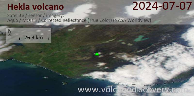
Latest satellite images

Hekla satellite image sat1Hekla satellite image sat2

Hekla Volcano Maps

Below is a selection of maps showing the location and surroundings of the volcano at various resolutions based on aerial-imagery / terrain maps. Feel free to use them for non-commercial purposes on your blog or website as long as you credit them with a link back to this page (click to copy it).
Satellite/aerial-type map of Hekla volcano (world scale)
Terrain-type map of Hekla volcano (world scale)
Satellite/aerial-type map of Hekla volcano (region scale large)
Terrain-type map of Hekla volcano (region scale large)
Satellite/aerial-type map of Hekla volcano (region scale medium)
Terrain-type map of Hekla volcano (region scale medium)
Satellite/aerial-type map of Hekla volcano (region scale small)
Terrain-type map of Hekla volcano (region scale small)
Satellite/aerial-type map of Hekla volcano (local scale large)
Terrain-type map of Hekla volcano (local scale large)
Satellite/aerial-type map of Hekla volcano (local scale medium)
Terrain-type map of Hekla volcano (local scale medium)
Satellite/aerial-type map of Hekla volcano (local scale small)
Terrain-type map of Hekla volcano (local scale small)
Satellite/aerial-type map of Hekla volcano (scale of 10s of km)
Terrain-type map of Hekla volcano (scale of 10s of km)
Satellite/aerial-type map of Hekla volcano (scale of 20-40 km)
Terrain-type map of Hekla volcano (scale of 20-40 km)
Satellite/aerial-type map of Hekla volcano (scale of approx. 10-20 km)
Terrain-type map of Hekla volcano (scale of approx. 10-20 km)
Satellite/aerial-type map of Hekla volcano (scale of 5-10 km)
Satellite/aerial-type map of Hekla volcano (scale of few kilometers)
Volcanoes & Earthquakes - new app for Android
Guaranteed tours
9-25 Jun 2025: Volcanoes and Spices - Sulawesi/Halmahera (Indonesia)
7-22 Jul 2025: From Krakatau to Bali - Java (Indonesia)
7-23 Jul 2025: Volcanoes and Spices - Sulawesi/Halmahera (Indonesia)
1-17 Aug 2025: Volcanoes and Spices - Sulawesi/Halmahera (Indonesia)
1-14 Oct 2025: Desert, salt and volcanoes - Danakil desert (Ethiopia)
4-12 Oct 2025: From Stromboli to Etna - Sicily and Eolian Islands (Italy)
6-21 Oct 2025: From Krakatau to Bali - Java (Indonesia)
3-19 Nov 2025: Volcanoes and Spices - Sulawesi/Halmahera (Indonesia)
= spaces available   = guaranteed   = few spaces left   = booked out
Mon, 15 Nov 2021, 21:05

Hekla volcano (Iceland): increased number of earthquakes in the area

Earthquakes near Hekla volcano in the past 7 days
Aftershocks of Thursday's strong magnitude 5.2 quake under neighboring Vatnafjöll volcano continue with more than 50 tremors detected over the past 48 hours. ... Read all
Tue, 14 Apr 2015, 11:43

Hekla volcano (Iceland): earthquake swarms

Epicenters of recent earthquakes south of Hekla
Small earthquake swarms occurred at shallow depths during the past days near the volcano. The quakes were located approx. 6-10 km south of Hekla volcano and at shallow depths around 5 km. ... Read all

On this page:

Try our free app!
Volcanoes & Earthquakes - new app for Android
Android | iOS version

More on VolcanoDiscovery

Why is there advertising on this site?

Support us - Help us upgrade our services!

We truly love working to bring you the latest volcano and earthquake data from around the world. Maintaining our website and our free apps does require, however, considerable time and resources.
We need financing to increase hard- and software capacity as well as support our editor team. We're aiming to achieve uninterrupted service wherever an earthquake or volcano eruption unfolds, and your donations can make it happen! Every donation will be highly appreciated. If you find the information useful and would like to support our team in integrating further features, write great content, and in upgrading our soft- and hardware, please make a donation (PayPal).

Planned features:Thanks to your past donations, these features have been added recently:
Download and Upgrade the Volcanoes & Earthquakes app to get one of the fastest seismic and volcano alerts online:
Android | IOS
Thank you!
Sources: VolcanoDiscovery / VolcanoAdventures and other sources as noted.
Use of material: Most text and images on our websites are owned by us. Re-use is generally not permitted without authorization. Contact us for licensing rights.
Volcanoes & Earthquakes
VolcanoDiscovery Home
Volcanoes | Earthquakes | Photos | Volcano News | | Shop | App
Adventure & Study Travel
Tours to Volcanoes and Volcanic Areas: walking tours, photo tours, study tours
Tours & Dates | FAQ | About us
Get our newsletter!
Company info
Contact | Legal info | Terms & conditions
Follow us
Follow us on facebook Follow us on Instagram Follow us on Bluesky Follow us on Twitter Visit our Youtube channel
EN | DE | EL | ES | FR | IT | RU
VolcanoDiscovery GmbH, Germany, Reg. nr.: HRB 103744, EU Tax Id: DE 297 465 123 owned and created by
Dr. Tom Pfeiffer, volcanologist, volcano photographer, tour organizer member of
IAVCEI
IAVCEI
Vulkanologische Gesellschaft
Volcanological Society
Ecotourism Greece
Ecotourism Greece
RUV insurance
Insured by R+V
VolcanoDiscovery © 2004- All Rights Reserved | Privacy - Cookie Settings