La Malinche Volcano
Updated: May 12, 2024 19:30 GMT -
stratovolcano 4461 m / 14,636 ft
Central Mexico, 19.23°N / -98.03°W
Current status: normal or dormant (1 out of 5)
Central Mexico, 19.23°N / -98.03°W
Current status: normal or dormant (1 out of 5)
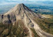
La Malinche is a Pleistocene andesitic-dacitic stratovolcano in the eastern Trans Mexican Volcanic Belt located only 25 km from the city of Puebla. La Malinche is heavily eroded and probably in in its final stages of activity, but could still erupt in the future, in which case it would pose a serious hazard to Puebla city.
La Malinche has several dacitic summit lava domes that have filled the summit crater. Several small flank vents are located on the flanks.
[smaller] [larger]
La Malinche volcano eruptions: 1170 BC ± 50 years (radiocarbon-dated), 7000 BP, 9000 BP, 9-12,000 BP, 21,500 BP, 39,000 BP
Latest nearby earthquakes
| Time | Mag. / Depth | Distance / Location | |||
| May 5, 03:32 am (Mexico City) | 3.7 9 km | 18 km (11 mi) to the N | Info | ||
Background
La Malinche is an eroded stratovolcano, cut by deep canyons, that rises to 4461 m NE of the city of Puebla. Malinche occupies an isolated position between the Popocatépetl-Iztaccíhuatl and Orizaba-Cofre de Perote volcanic ranges. Much of the andesitic-dacitic volcano was constructed during the Pleistocene, and the summit exhibits evidence of glacial erosion.This volcano remains relatively unstudied, however, recent work has identified tephra layers of Holocene age that originated from Volcán la Malinche. Several tuff cones and explosion craters, at least one of Holocene age, are found on the flanks of the volcano; one of the most prominent of these is the Xalapaxco tuff cone complex on the lower NE flank. Holocene lahars from La Malinche associated with an eruption about 3100 years ago reached the Puebla basin and affected precolumbian settlements.
(Smithsonian / GVP)
Latest satellite images