Oshima Volcano
Updated: Apr 28, 2024 10:22 GMT -
stratovolcano 764 m / 2,507 ft
Izu Islands, Japan, 34.72°N / 139.4°E
Current status: normal or dormant (1 out of 5)
Izu Islands, Japan, 34.72°N / 139.4°E
Current status: normal or dormant (1 out of 5)
Izu-Oshima volcano, 伊豆大島 Izu-ōshima) is the northernmost of the Izu islands of Japan, and one of the world's most active volcanoes. It is a mostly submerged stratovolcano that forms an 11 x 13 km island.
Oshima erupts very frequently, on average every 1-3 years, but has been quiet since 1990, which is an unusual long interval compared to its activity in historic times.
Eruptions at Oshima volcano occur from both summit and flank vents and its lavas are relatively fluid. The eruptions often produce lava fountains, strombolian activity, lava flows and the formation of lava lakes.
[smaller] [larger]
Oshima volcano eruptions: 1990, 1987-88, 1986, 1974, 1971, 1970, 1970, 1969, 1968, 1968, 1967, 1965-66, 1962-65, 1961(?), 1959-60, 1959, 1958, 1957, 1956, 1956(?), 1953-54, 1950-51, 1940, 1939, 1939, 1938, 1937, 1935, 1934, 1934(?), 1933, 1928, 1922-23, 1920(?), 1919, 1915, 1914, 1912-13, 1910, 1876-77, 1870, 1868?, 1846, 1837-38, 1827, 1822-24, 1803, 1792, 1789, 1783-86, 1777-79, 1695, 1684-90, 1636-38, 1612-13, 1600-01, 1588, 1552, 1527, 1442, 1421, 1416, 1415, 1338, 1267, 1112, 936, 886, 854(?), 751, 684(?), 681(?), 680(?), 654, 630, 605
Latest nearby earthquakes
Background
from Smithsonian / GVP volcano information:Oshima volcano in Sagami Bay, east of the Izu Peninsula, is the northernmost of the Izu Islands. The broad, low stratovolcano forms an 11 x 13 km island and was constructed over the remnants of three dissected stratovolcanoes.
It is capped by a 4-km-wide caldera with a central cone, Mihara-yama, that has been the site of numerous historical eruptions. More than 40 parasitic cones are located within the caldera and along two parallel rift zones trending NNW-SSE. Although Oshima is a dominantly basaltic volcano, strong explosive activity has occurred at intervals of 100-150 years throughout the past few thousand years. Historical activity at Oshima dates back to the 7th century AD.
Oshima Volcano Photos
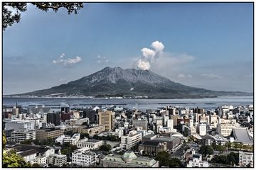
View of Sakurajima from Kagoshima city (Photo: Ivana Dorn)
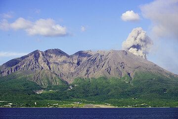
Small ash puff on the afternoon of 19 July, seen from Kagoshima Bay. (Photo: Tom Pfeiffer)
Eruptions of Oshima volcano
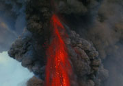
1968 eruption & lava fountains
A major eruption from Izu-Oshima volcano in 1986 produced spectacular lava fountains up to 1600 m height and a 16-km-high subplinian eruption column. More than 12,000 persons were evacuated from the island.
Tall lava fountains:
The 1968 Oshima lava fountain is the second highest ever (photographically) recorded lava fountain from a volcano. The highest is the 1500-2000 m tall lava fountain from the Voragine on Etna volcano on 4 September 1999, the third the 1000-1200 m tall lava fountain from Etna's SE crater during the paroxysm on 23 May 2000.
For comparison, the tallest lava fountains observed on Hawaii were about 590 m tall from Kilauea Iki on 21 November 1959. The specacular lava fountains from Pu'u O'o during 1983-85 reached up to 500 m.
Latest satellite images