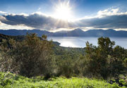
| RSS | EN | DE | EL | ES | FR | IT | RU

San Pedro Volcano

Updated: Jul 3, 2025 00:17 GMT -
stratovolcano
Northern Chile, Bolivia and Argentina (South America), -21.88°S / -68.4°W
Summit height: 6145 m / 20,161 ft
Current status: normal or dormant (1 out of 5)

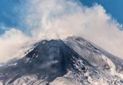
San Pedro volcano in the Atacama desert of northern Chile is one of the highest active volcanoes in the world.
San Pedro volcano is a twin volcano with 2 peaks, San Pedro (the western summit) and the older sister volcano San Pablo (6092 m) in the east.

A large debris avalanche, similar to the one at Mt St Helend in 1980, occurred at San Pedro in the past, and the present-day cone grew within the depression. The debris avalanche deposit is visible on the western lower slopes of San Pedro.
Thick dacitic lava flows with steep-sided fronts cover the upper slopes of San Pedro's cone which has a crater. There is a young-looking scoria cone on the western flank (La Poruña), which erupted an 8 km-long lava flow about 103,000 years ago.
Reports of varying degrees of reliability have recorded a number of eruptions in the past centuries.

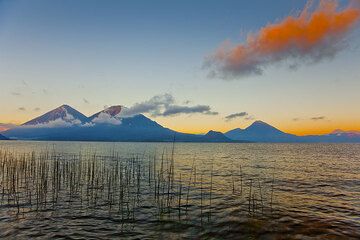
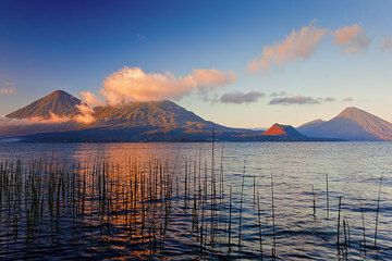
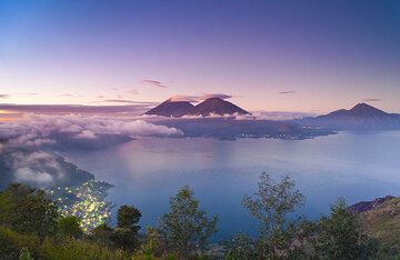
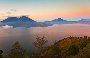
Note: a volcano with the same name is at Lake Atitlán in the Guatemalan Highlands, forming the prominent group of San Pedro, Tolimán, and Atitlán volcanoes.

[smaller] [larger]
Typical eruption style: explosive and effusive
San Pedro volcano eruptions: 1960(?), 1938, 1923(?), 1917(?), 1916(?), 1911, 1901, 1891(?), 1877(?), 1870(?)

Latest nearby earthquakes

Date and TimeMag / DepthDistance / Location
Jul 2, 10:25 am (GMT -4)
3.1

112 km
29 km (18 mi) to the SW Chile: 61 km Al NE De Calama  I FELT IT Info
Tuesday, July 1, 2025 GMT (1 quake)
Jul 1, 02:15 am (Universal Time)
3.3

134 km
25 km (16 mi) to the N 53 km Al SO De Ollagüe  I FELT IT Info
Saturday, June 28, 2025 GMT (1 quake)
Jun 28, 02:15 pm (Universal Time)
2.8

115 km
16 km (9.8 mi) to the W 74 km Al NE De Calama Info
Thursday, June 26, 2025 GMT (1 quake)
Jun 26, 05:59 pm (GMT -4)
2.8

112 km
24 km (15 mi) to the W 75 km Al NE De Calama Info
Monday, June 23, 2025 GMT (1 quake)
Jun 23, 10:18 am (Santiago)
3.1

107 km
25 km (16 mi) to the NW 71 km Al SO De Ollagüe Info
Sunday, June 22, 2025 GMT (1 quake)
Jun 21, 09:30 pm (Santiago)
3.1

123 km
28 km (17 mi) to the NW 72 km Al SO De Ollagüe Info
Saturday, June 21, 2025 GMT (1 quake)
Jun 21, 07:08 pm (Santiago)
3.6

131 km
19 km (12 mi) to the NW 69 km Al SO De Ollagüe Info
Thursday, June 19, 2025 GMT (1 quake)
Jun 19, 05:40 pm (Santiago)
3.7

139 km
21 km (13 mi) to the W 73 km northeast of Calama, Provincia de El Loa, Region de Antofagasta, Chile Info

San Pedro Volcano Photos

Significant volcanic eruptions: San Pedro volcano

In the past 10,000 years, San Pedro has had only one confirmed historic eruption ###WHEN1###|only one confirmed historic eruption ###WHEN1### and one ###WHEN2### inferred from geological evidence|only one confirmed historic eruption ###WHEN1###, but at least ###NUM_INFERRED### eruptions can be inferred from geological evidence|at least ###NUM_CONFIRMED### confirmed eruptions, all documented by historical records or observations|at least ###NUM_CONFIRMED### confirmed volcanic eruptions, out of which ###NUM_HISTORIC### are documented by historical records, while the others can be inferred from geological evidence.
No historic eruptions are known from San Pedro volcano, but at least one eruption ###WHEN2### can be inferred from geological evidence|evidence from at least ###NUM_CONFIRMED### eruptions during the past 10,000 years can be found in the geological record.
There are only 10 uncertain or discredited eruptions from San Pedro volcano during the past 10,000 years.
The table below lists all known eruptions (date in bold face) of San Pedro volcano in historic times and during the past 10,000 years. Updates on the most recent volcanic activity of San Pedro can be found on the news page of San Pedro volcano.
DateNoteVEIDeathsDamage
?? 1960 Dec 2
Uncertain Eruption
Historical obs./docs.
2
?? 1938 Feb
Uncertain Eruption
Historical obs./docs.
2
?? 1923
Uncertain Eruption
?
?? 1917
Uncertain Eruption
?
?? 1916
Uncertain Eruption
?
?? 1911 Sep
Uncertain Eruption
Historical obs./docs.
2
?? 1901 May 25 - Aug
Uncertain Eruption
Historical obs./docs.
2
?? 1891 ?
Uncertain Eruption
Historical obs./docs.
2
?? 1877 ?
Uncertain Eruption
Historical obs./docs.
2
?? 1870
Uncertain Eruption
?
Remark:
Our list of volcanic eruptions closely follows the database of eruptions of the Smithsonian's Global Volcanism Project (GVP), the internationally most recognized data source for volcanic eruptions, but also includes significant eruptive episodes or related volcano events. "Volcanic eruptions" are usually to be understood as sequences of individual eruptive episodes that can follow each other, or even overlap (if several vents are involved), and can last many years, decades or even longer. For example, the current activity of Stromboli volcano is understood as a single eruption that has been ongoing since 1934.
Sources: NOAA National Centers for Environmental Information (NCEI), Global Significant Volcanic Eruptions Database. doi:10.7289/V5TD9V7K | Global Volcanism Project / Smithsonian Institution

Latest satellite images

SanPedro satellite image sat1SanPedro satellite image sat2

San Pedro Volcano Maps

Below is a selection of maps showing the location and surroundings of the volcano at various resolutions based on aerial-imagery / terrain maps. Feel free to use them for non-commercial purposes on your blog or website as long as you credit them with a link back to this page (click to copy it).
Satellite/aerial-type map of San Pedro volcano (world scale)
Terrain-type map of San Pedro volcano (world scale)
Satellite/aerial-type map of San Pedro volcano (region scale large)
Terrain-type map of San Pedro volcano (region scale large)
Satellite/aerial-type map of San Pedro volcano (region scale medium)
Terrain-type map of San Pedro volcano (region scale medium)
Satellite/aerial-type map of San Pedro volcano (region scale small)
Terrain-type map of San Pedro volcano (region scale small)
Satellite/aerial-type map of San Pedro volcano (local scale large)
Terrain-type map of San Pedro volcano (local scale large)
Satellite/aerial-type map of San Pedro volcano (local scale medium)
Terrain-type map of San Pedro volcano (local scale medium)
Satellite/aerial-type map of San Pedro volcano (local scale small)
Terrain-type map of San Pedro volcano (local scale small)
Satellite/aerial-type map of San Pedro volcano (scale of 10s of km)
Terrain-type map of San Pedro volcano (scale of 10s of km)
Satellite/aerial-type map of San Pedro volcano (scale of 20-40 km)
Terrain-type map of San Pedro volcano (scale of 20-40 km)
Satellite/aerial-type map of San Pedro volcano (scale of approx. 10-20 km)
Terrain-type map of San Pedro volcano (scale of approx. 10-20 km)
Satellite/aerial-type map of San Pedro volcano (scale of 5-10 km)
Satellite/aerial-type map of San Pedro volcano (scale of few kilometers)
Volcanoes & Earthquakes - new app for Android
Guaranteed tours
1-17 Aug 2025: Volcanoes and Spices - Sulawesi/Halmahera (Indonesia)
1-14 Oct 2025: Desert, salt and volcanoes - Danakil desert (Ethiopia)
4-12 Oct 2025: From Stromboli to Etna - Sicily and Eolian Islands (Italy)
6-21 Oct 2025: From Krakatau to Bali - Java (Indonesia)
3-19 Nov 2025: Volcanoes and Spices - Sulawesi/Halmahera (Indonesia)
= spaces available   = guaranteed   = few spaces left   = booked out

No news in this list.

On this page:

Try our free app!
Volcanoes & Earthquakes - new app for Android
Android | iOS version

More on VolcanoDiscovery

Why is there advertising on this site?

Support us - Help us upgrade our services!

We truly love working to bring you the latest volcano and earthquake data from around the world. Maintaining our website and our free apps does require, however, considerable time and resources.
We need financing to increase hard- and software capacity as well as support our editor team. We're aiming to achieve uninterrupted service wherever an earthquake or volcano eruption unfolds, and your donations can make it happen! Every donation will be highly appreciated. If you find the information useful and would like to support our team in integrating further features, write great content, and in upgrading our soft- and hardware, please make a donation (PayPal).

Planned features:Thanks to your past donations, these features have been added recently:
Download and Upgrade the Volcanoes & Earthquakes app to get one of the fastest seismic and volcano alerts online:
Android | IOS
Thank you!
Sources: VolcanoDiscovery / VolcanoAdventures and other sources as noted.
Use of material: Most text and images on our websites are owned by us. Re-use is generally not permitted without authorization. Contact us for licensing rights.
Volcanoes & Earthquakes
VolcanoDiscovery Home
Volcanoes | Earthquakes | Photos | Volcano News | | Shop | App
Adventure & Study Travel
Tours to Volcanoes and Volcanic Areas: walking tours, photo tours, study tours
Tours & Dates | FAQ | About us
Get our newsletter!
Company info
Contact | Legal info | Terms & conditions
Follow us
Follow us on facebook Follow us on Instagram Follow us on Bluesky Follow us on Twitter Visit our Youtube channel
EN | DE | EL | ES | FR | IT | RU
VolcanoDiscovery GmbH, Germany, Reg. nr.: HRB 103744, EU Tax Id: DE 297 465 123 owned and created by
Dr. Tom Pfeiffer, volcanologist, volcano photographer, tour organizer member of
IAVCEI
IAVCEI
Vulkanologische Gesellschaft
Volcanological Society
Ecotourism Greece
Ecotourism Greece
RUV insurance
Insured by R+V
VolcanoDiscovery © 2004- All Rights Reserved | Privacy - Cookie Settings