Tupungatito Volcano
Updated: Apr 28, 2024 08:33 GMT -
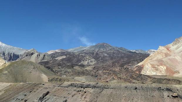
stratovolcano 6000 m / 19,685 ft
Central Chile and Argentina (South America), -33.4°S / -69.8°W
Current status: normal or dormant (1 out of 5)
Central Chile and Argentina (South America), -33.4°S / -69.8°W
Current status: normal or dormant (1 out of 5)
Last update: 24 Feb 2022 (volcanic earthquake on 17 Aug 2015)
Tupungatito volcano is the northernmost historically active volcano of the central Chilean Andes. It is located on the Chile/Argentina border 99 km east of Santiago.
Tupungatito's name is a diminuitive version of the massive Cerro Tupungato stratovolcano located immediately southwest.
Historic eruptions recorded since 1829 were frequent, but usually small explosive ash eruptions. Eruptive activity of Tupungatito is controlled by a N-S-striking fracture and fault system. The volcano possibly has a secondary magma chamber.
[smaller] [larger]
Tupungatito volcano eruptions: 1986, 1980, 1968, 1964, 1961, 1960, 1959, 1959, 1958, 1946-47, 1925, 1907, 1901, 1897, 1889-90, 1881?, 1861, 1835?, 1829
Latest nearby earthquakes
| Time | Mag. / Depth | Distance / Location | |||
Background
Tupungatito consists of a group of 12 young andesitic and basaltic andesite craters and a cinder cone cone at the NW end of the 4-km-wide, glacier-filled Nevado Sin Nombre caldera on the southern side of the volcano.The caldera is breached to the NW. Many lava flows from the northernmost crater have traveled through the breach.
It has recently been suggested that Tupungatito and other volcanoes in the Andes tend to erupt more frequently in the aftermath of earthquakes, which may be triggers of new activity. Tupungatito erupted within a year of both the 1906 and 1960 earthquakes, as did Calbuco and Villarrica. Similarly, Osorno and Puntiagudo both erupted soon after Chile's 1837 earthquake.
---
Sources:
- Y. Dzierma and H. Wehrmann (2010) "Statistical eruption forecast for the Chilean Southern Volcanic Zone: typical probabilities of volcanic eruptions as baseline for possibly enhanced activity following the large 2010 Concepci´on earthquake", Nat. Hazards Earth Syst. Sci., 10, 2093–2108
- M. Muñoz (2010) "Eruption patterns of the chilean volcanoes Villarrica, Llaima, and Tupungatito", Pure and Applied Geophysics, Volume 121, Numbers 5-6, 835-852
Latest satellite images