Voyampolsky Volcano
Updated: Jun 16, 2025 04:26 GMT -
Shield volcanoes
Kamchatka, Russia, 58.37°N / 160.62°E 
Summit height: 1225 m / 4,019 ft
Current status: (probably) extinct (0 out of 5)
[smaller] [larger]
Voyampolsky volcano eruptions: unknown, no recent eruptions
Latest nearby earthquakes
| Date and Time | Mag / Depth | Distance / Location | |||
|---|---|---|---|---|---|
Background
Voyampolsky and Kakhtana are two Icelandic-type basaltic to basaltic-andesite shield volcanoes that form the NW-most volcanoes of the N-S-trending Sredinny Range, which stretches across the western side of Kamchatka. The two shield volcanoes, 1225 and 1217 m high, respectively, are located near the headwaters of the Kakhtana River and were constructed along an E-W line west of the crest of the Sredinny Range. Icelandic-type basaltic to basaltic-andesite shield volcanoes extend the length of the Sredinny Range, which has a large basaltic component (Erlich and Gorshkov, 1979). Early geologic studies in the Sredinny Range (Ogorodov et al., 1972) identified numerous Holocene eruptive centers based primarily on morphological criteria. However, later work has suggested that Sredinny Range volcanoes are less mantled by Holocene tephras than eastern Kamchatka volcanoes and therefore appear more youthful, so that Holocene eruptions are uncertain for many of these Sredinny Range eruptive vents.---
Smithsonian / GVP volcano information
Latest satellite images
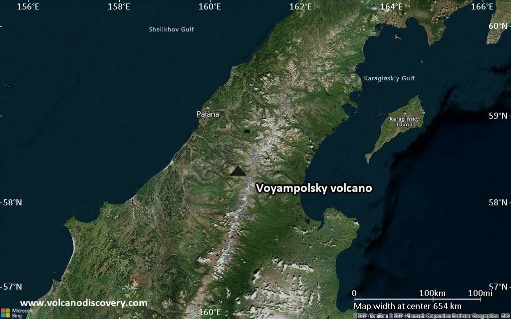
Voyampolsky Volcano Maps
Below is a selection of maps showing the location and surroundings of the volcano at various resolutions based on aerial-imagery / terrain maps. Feel free to use them for non-commercial purposes on your blog or website as long as you credit them with a link back to this page (click to copy it).

Satellite/aerial-type map of Voyampolsky volcano (world scale)

Terrain-type map of Voyampolsky volcano (world scale)

Satellite/aerial-type map of Voyampolsky volcano (region scale large)

Terrain-type map of Voyampolsky volcano (region scale large)

Satellite/aerial-type map of Voyampolsky volcano (region scale medium)

Terrain-type map of Voyampolsky volcano (region scale medium)
Satellite/aerial-type map of Voyampolsky volcano (region scale small)

Terrain-type map of Voyampolsky volcano (region scale small)

Satellite/aerial-type map of Voyampolsky volcano (local scale large)

Terrain-type map of Voyampolsky volcano (local scale large)

Satellite/aerial-type map of Voyampolsky volcano (local scale medium)

Terrain-type map of Voyampolsky volcano (local scale medium)

Satellite/aerial-type map of Voyampolsky volcano (local scale small)

Terrain-type map of Voyampolsky volcano (local scale small)

Satellite/aerial-type map of Voyampolsky volcano (scale of 10s of km)

Terrain-type map of Voyampolsky volcano (scale of 10s of km)

Satellite/aerial-type map of Voyampolsky volcano (scale of 20-40 km)

Terrain-type map of Voyampolsky volcano (scale of 20-40 km)

Satellite/aerial-type map of Voyampolsky volcano (scale of approx. 10-20 km)

Terrain-type map of Voyampolsky volcano (scale of approx. 10-20 km)

Satellite/aerial-type map of Voyampolsky volcano (scale of 5-10 km)

Satellite/aerial-type map of Voyampolsky volcano (scale of few kilometers)