| RSS | EN | DE | EL | ES | FR | IT | RU

Arenal Volcano

Updated: May 1, 2025 17:16 GMT -
Stratovolcano
Costa Rica, 10.46°N / -84.7°W
Summit height: 1657 m / 5,436 ft
Current status: normal or dormant (1 out of 5)
Last update: 23 Apr 2025
Arenal volcano (image: Michael Beck)

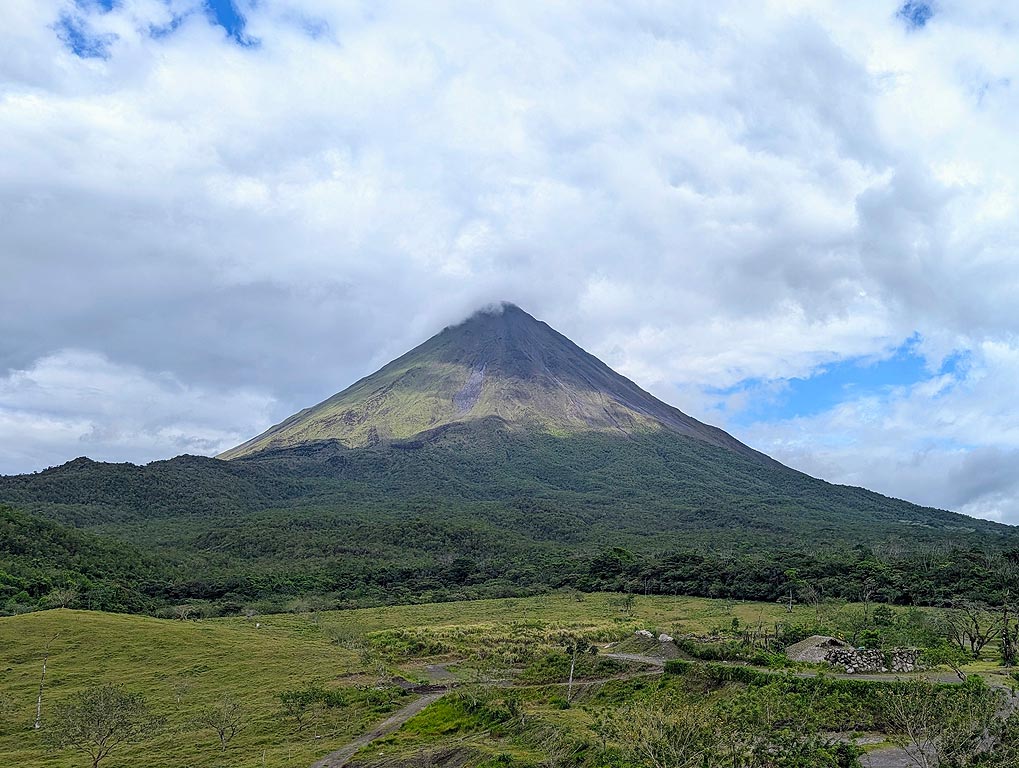
Arenal, a major tourist attraction in Costa Rica, is one of the most active volcanoes of Central America. Since a major eruption in 1968, it has been in near-continuous activity building a lava dome and displaying mild explosive activity from the summit crater.

[smaller] [larger]
Typical eruption style: Explosive. Near continuous strombolian activity, occasional major explosive events and lava flows.
Arenal volcano eruptions: 1968-2011, 1968 (major explosion), 1922, 1915(?), 1750, 1530, around 1350 (large, sub-Plinian eruption)

Latest nearby earthquakes

Date and TimeMag / DepthDistance / Location
Apr 21, 03:17 pm (Universal Time)
2?

54 km
26 km (16 mi) to the S 30 km north of Puntarenas, Provincia de Puntarenas, Costa Rica (unconfirmed) Info
Sunday, April 20, 2025 GMT (1 quake)
Apr 20, 12:43 am (Universal Time)
2?

151 km
28 km (17 mi) to the NW 45 km southeast of San José, Provincia de Alajuela, Costa Rica (unconfirmed) Info

Background

Volcán Arenal, a beautiful, 1657-m high conical andesitic stratovolcano near Lake Arena, is the youngest and one of the most active stratovolcano in Costa Rica. It is famous for a large explosive eruption in 1968 that killed several people and threw incandescent bombs to 5 km distance from the vent.
Arenal lies along a volcanic chain where activity has migrated to the NW over the past 2 million years, from the late-Pleistocene Los Perdidos lava domes through the Pleistocene-to-Holocene Chato volcano, which contains a 500-m-wide, lake-filled summit crater. The earliest known eruptions of Arenal took place about 7000 years ago, and it was active simulataneously with Cerro Chato volcano until the activity of Chato ended about 3500 years ago.
Growth of Arenal has been characterized by periodic major explosive eruptions at several-hundred-year intervals and periods of lava effusion that armor the cone. Arenal's most recent eruptive period began with a major explosive eruption in 1968. Continuous explosive activity accompanied by slow lava effusion and the occasional emission of pyroclastic flows has occurred since then from vents at the summit and on the upper western flank.
Source: GVP, Smithsonian Institution

Significant volcanic eruptions: Arenal volcano

In the past 10,000 years, Arenal has had at least 27 confirmed volcanic eruptions, out of which 2 are documented by historical records, while the others can be inferred from geological evidence.
There is one uncertain or discredited eruption in 1915 from Arenal volcano.
The table below lists all known eruptions (date in bold face) of Arenal volcano since around 1000 BC. Updates on the most recent volcanic activity of Arenal can be found on the news page of Arenal volcano.
DateNoteVEIDeathsDamage
1968 Jul 29 - 2010 Dec 16 ±15 d.W flank & summit
Historical obs./docs.
3
2000 Aug 23
(eruption 1968 Jul 29 - 2010 Dec 16 ±15 d.)
Historical obs./docs.
32
Info
1988 Jul 6
(eruption 1968 Jul 29 - 2010 Dec 16 ±15 d.)
Historical obs./docs.
31
Info
1975 Jun 17
(eruption 1968 Jul 29 - 2010 Dec 16 ±15 d.)
Historical obs./docs.
32
Info
1968 Jul 29
(eruption 1968 Jul 29 - 2010 Dec 16 ±15 d.)
Historical obs./docs.
380
light
Info
1922 Oct 5 ? - Oct 23 ?
Historical obs./docs.
2
?? 1915 Feb 5
Uncertain Eruption
2?
1750 ±50 y.Summit and NW flank (A2 lava flows)0?
1440 ? AD2?
1400 ? AD4
1030 ? AD4
1020 ? AD4
750 ±50 y. AD4
700 ? AD4
650 ±100 y. AD4
550 ? AD4
400 ? AD4
170 ±200 y. BC4
270 ? BC4
380 ±200 y. BC4
830 ±500 y. BC0?
Remark:
Our list of volcanic eruptions closely follows the database of eruptions of the Smithsonian's Global Volcanism Project (GVP), the internationally most recognized data source for volcanic eruptions, but also includes significant eruptive episodes or related volcano events. "Volcanic eruptions" are usually to be understood as sequences of individual eruptive episodes that can follow each other, or even overlap (if several vents are involved), and can last many years, decades or even longer. For example, the current activity of Stromboli volcano is understood as a single eruption that has been ongoing since 1934.
Sources: NOAA National Centers for Environmental Information (NCEI), Global Significant Volcanic Eruptions Database. doi:10.7289/V5TD9V7K | Global Volcanism Project / Smithsonian Institution

Arenal Volcano FAQ

+When was the last eruption of Arenal volcano?

+How often does Arenal volcano erupt?

+How active is Arenal volcano at present?

+When was the largest eruption of Arenal volcano?

Latest satellite images

Arenal satellite image sat1Arenal satellite image sat2

Arenal Volcano Maps

Below is a selection of maps showing the location and surroundings of the volcano at various resolutions based on aerial-imagery / terrain maps. Feel free to use them for non-commercial purposes on your blog or website as long as you credit them with a link back to this page (click to copy it).
Satellite/aerial-type map of Arenal volcano (world scale)
Terrain-type map of Arenal volcano (world scale)
Satellite/aerial-type map of Arenal volcano (region scale large)
Terrain-type map of Arenal volcano (region scale large)
Satellite/aerial-type map of Arenal volcano (region scale medium)
Terrain-type map of Arenal volcano (region scale medium)
Satellite/aerial-type map of Arenal volcano (region scale small)
Terrain-type map of Arenal volcano (region scale small)
Satellite/aerial-type map of Arenal volcano (local scale large)
Terrain-type map of Arenal volcano (local scale large)
Satellite/aerial-type map of Arenal volcano (local scale medium)
Terrain-type map of Arenal volcano (local scale medium)
Satellite/aerial-type map of Arenal volcano (local scale small)
Terrain-type map of Arenal volcano (local scale small)
Satellite/aerial-type map of Arenal volcano (scale of 10s of km)
Terrain-type map of Arenal volcano (scale of 10s of km)
Satellite/aerial-type map of Arenal volcano (scale of 20-40 km)
Terrain-type map of Arenal volcano (scale of 20-40 km)
Satellite/aerial-type map of Arenal volcano (scale of approx. 10-20 km)
Terrain-type map of Arenal volcano (scale of approx. 10-20 km)
Satellite/aerial-type map of Arenal volcano (scale of 5-10 km)
Satellite/aerial-type map of Arenal volcano (scale of few kilometers)
Volcanoes & Earthquakes - new app for Android
Guaranteed tours
9-25 Jun 2025: Volcanoes and Spices - Sulawesi/Halmahera (Indonesia)
7-22 Jul 2025: From Krakatau to Bali - Java (Indonesia)
7-23 Jul 2025: Volcanoes and Spices - Sulawesi/Halmahera (Indonesia)
1-17 Aug 2025: Volcanoes and Spices - Sulawesi/Halmahera (Indonesia)
1-14 Oct 2025: Desert, salt and volcanoes - Danakil desert (Ethiopia)
4-12 Oct 2025: From Stromboli to Etna - Sicily and Eolian Islands (Italy)
6-21 Oct 2025: From Krakatau to Bali - Java (Indonesia)
3-19 Nov 2025: Volcanoes and Spices - Sulawesi/Halmahera (Indonesia)
= spaces available   = guaranteed   = few spaces left   = booked out
Wed, 18 Sep 2013, 10:59

Arenal volcano (Costa Rica): increased rockfalls as possible sign of volcano becoming more active

OVSICORI mentioned that rockfalls with rumbling noises have increased at the volcano over the past weeks. This could suggest that the volcano has started to wake up from its 3 years of slumber. ... Read all
Thu, 12 Sep 2013, 08:14

Arenal volcano (Costa Rica) activity update

OVSICORI-UNA reported that plumes composed mainly of water vapor rose from the NE and SE edges of Arenal's Crater C on 8 and 9 September. Tremors indicative of hydrothermal and magmatic activity were detected on 8 September. Read all

On this page:

Try our free app!
Volcanoes & Earthquakes - new app for Android
Android | iOS version

More on VolcanoDiscovery

Why is there advertising on this site?

Support us - Help us upgrade our services!

We truly love working to bring you the latest volcano and earthquake data from around the world. Maintaining our website and our free apps does require, however, considerable time and resources.
We need financing to increase hard- and software capacity as well as support our editor team. We're aiming to achieve uninterrupted service wherever an earthquake or volcano eruption unfolds, and your donations can make it happen! Every donation will be highly appreciated. If you find the information useful and would like to support our team in integrating further features, write great content, and in upgrading our soft- and hardware, please make a donation (PayPal).

Planned features:Thanks to your past donations, these features have been added recently:
Download and Upgrade the Volcanoes & Earthquakes app to get one of the fastest seismic and volcano alerts online:
Android | IOS
Thank you!
Sources: VolcanoDiscovery / VolcanoAdventures and other sources as noted.
Use of material: Most text and images on our websites are owned by us. Re-use is generally not permitted without authorization. Contact us for licensing rights.
Volcanoes & Earthquakes
VolcanoDiscovery Home
Volcanoes | Earthquakes | Photos | Volcano News | | Shop | App
Adventure & Study Travel
Tours to Volcanoes and Volcanic Areas: walking tours, photo tours, study tours
Tours & Dates | FAQ | About us
Get our newsletter!
Company info
Contact | Legal info | Terms & conditions
Follow us
Follow us on facebook Follow us on Instagram Follow us on Bluesky Follow us on Twitter Visit our Youtube channel
EN | DE | EL | ES | FR | IT | RU
VolcanoDiscovery GmbH, Germany, Reg. nr.: HRB 103744, EU Tax Id: DE 297 465 123 owned and created by
Dr. Tom Pfeiffer, volcanologist, volcano photographer, tour organizer member of
IAVCEI
IAVCEI
Vulkanologische Gesellschaft
Volcanological Society
Ecotourism Greece
Ecotourism Greece
RUV insurance
Insured by R+V
VolcanoDiscovery © 2004- All Rights Reserved | Privacy - Cookie Settings