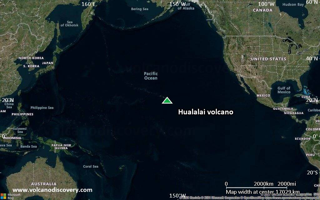
| RSS | EN | DE | EL | ES | FR | IT | RU

Hualalai Vulkan

Updated: 25. Jun. 2025 15:48 GMT -
shield volcano
Big Island (Hawai'i), 19.69°N / -155.87°W
Summit height: 2523 m / 8,277 ft
Aktueller Status: normal / ruhend (1 von 5)
Last update: 22 Mai 2022 (M 4.7 quake yesterday)

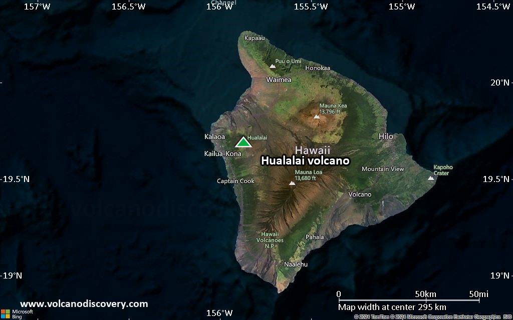
Hualalai, the third of the active shield volcano volcanoes on Hawai'i, is located to the northwest and wet of its giant neighbors Mauna Loa and Mauna Kea. Hualalai volcano last erupted during 1800-1801, when it produced lava flows from 5 fissure vents that reached the sea and buried Hawaiian villages.
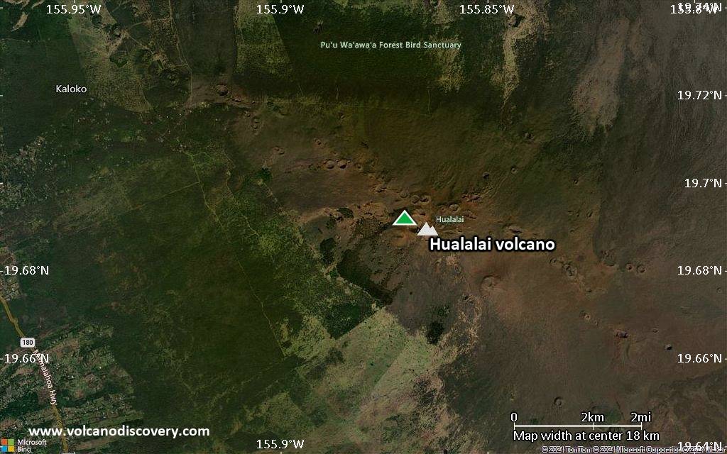
Hualalai began erupting about 800,000 years ago and breached the sea surface about 300,000 years ago. The volcano has 3 rift zones, the most prominent is the northwest rift, which is about 40 km long and continues into the sea to a depth of 3000 m.

[smaller] [larger]
Typische Aktivität: effusive
Ausbrüche des Hualalai: 1801

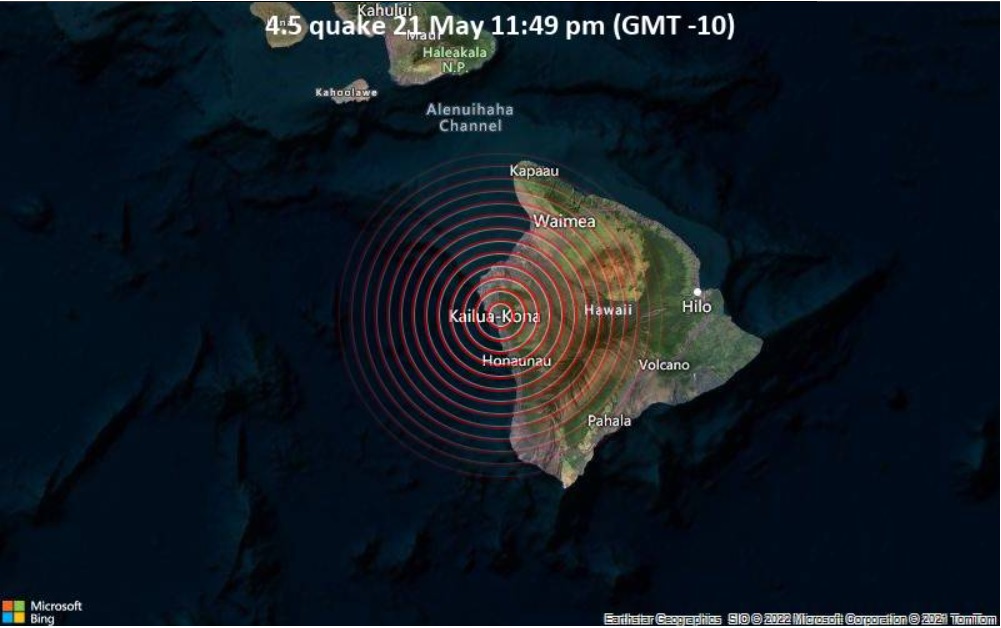
Letzte Erdbeben in der Nähe

Datum und UhrzeitMag / TiefeDistanz / Ort
12. Jun. 03:07 (Weltzeit)
2.3

12 km
19 km südlich 4.5 km nordöstlich von Captain Cook, Hawaii County, Hawaii, USA Info

Beschreibung

Hualalai volcano, at the western end of the island, is the third youngest shield volcano on Hawaii. At 2523 m, it is dwarfed by its massive neighbors, Mauna Loa and Mauna Kea. Three rift zones, dotted with cinder cones and spatter cones, trend north, NW, and SE, and converge about 5 km east of the summit. Detailed mapping has shown that 95% of the surface area of the basaltic shield volcano is of Holocene age, more than half is less than 3000 years old, and a quarter is less than 1000 years old.
The only historical eruptions of Hualalai took place during the end of the 18th century and in 1801, when lava flows from vents on the NW rift zone reached the sea and buried Hawaiian villages; the 1801 Huehue lava flow underlies part of the international airport at Kona. The earlier of the two flows, the Kaupulehu lava flow, is notable for its large quantities of lava-encrusted mafic and ultramafic nodular xenoliths.
(Smithsonian / GVP volcano information)

Bedeutende Vulkanausbrüche: Hualalai volcano

In the past 10,000 years, Hualalai has had at least 22 confirmed volcanic eruptions, out of which 2 are documented by historical records, while the others can be inferred from geological evidence.
The table below lists all known eruptions (date in bold face) of Hualalai volcano since around 3000 BC. Updates on the most recent volcanic activity of Hualalai can be found on the news page of Hualalai volcano.
DatumHinweisVEITodesopferSchaden
1800 - 1801NW rift zone (520 m)
Hist. dokumentiert
?
unbekannt
1800
(Ausbruch 1800 - 1801)
Hist. dokumentiert
02
unbekannt
Info
1784
(Ausbruch 1784 ±7 y.)
Hist. dokumentiert
01-50 (*)
unbekannt
Info
1784 ±7 y.NW rift zone (1400-1900 m)
Hist. dokumentiert
?
unbekannt
1650 ±50 y. ADNW rift zone (Luamakami)1
unbekannt
1240 ±150 y. ADSSE rift zone (Waha Pele)2
unbekannt
1150 ? ADNW rift zone (Puu Alauawa, Nahaha)?
unbekannt
1050 ±100 y. ADSSE rift zone (3 km NE of Waha Pele)1
unbekannt
920 ±50 y. ADNW rift zone (2 km NW of Luamakami)?
unbekannt
770 ±200 y. ADSSE rift zone (4.5 km NW of Waha Pele1
unbekannt
80 ±75 y. BCNorth rift zone (1130-1830 m)?
unbekannt
350 ±75 y. BCSE flank (1 km west of Waha Pehe)?
unbekannt
400 ±75 y. BCNW rift zone (Luamakami)?
unbekannt
440 ±50 y. BCNorth rift zone (3 km NE of Hainoa)?
unbekannt
720 ±75 y. BCNorth rift zone (700 m ENE of Hainoa)?
unbekannt
1080 ±200 y. BC?
unbekannt
1150 ±75 y. BCNW rift zone (0.7 km NW of Luamakami)?
unbekannt
1650 ±200 y. BC?
unbekannt
2040 ±75 y. BCNW rift zone (0.3 km NW of Hainoa)?
unbekannt
2440 ±75 y. BCNW rift zone (1 km W of Hainoa Crater)?
unbekannt
2770 ±75 y. BC?
unbekannt
(*) Geschätzte Zahlen
Anmerkung:
Unsere Liste von Vulkanausbrüchen orientiert sich eng an der Datenbank des Global Volcanism Project (GVP) des Smithsonian Instituts, der international anerkanntesten globalen Datenquelle für Vulkanausbrüche. Sie schließt aber auch bedeutende Eruptionsepisoden oder damit zusammenhängende Vulkanereignisse ein. Unter "Vulkanausbrüchen" versteht man in der Regel meist Serien einzelner Eruptionsepisoden, die zeitlich aufeinander folgen oder sich (bei mehreren beteiligten Ausbruchspunkten an einem Vulkan) auch überlappen können und unter Umständen viele Jahre, Jahrzehnte oder noch länger andauern können. So ist z.B. die aktuelle Tätigkeit des Stromboli als ein einziger Ausbruch verstanden, der seit 1934 anhält.
Quellen: NOAA National Centers for Environmental Information (NCEI), Global Significant Volcanic Eruptions Database. doi:10.7289/V5TD9V7K | Global Volcanism Project / Smithsonian Institution

Ausbrüche des Vulkans Hualalai


1929 earthquake swarm
A seismic swarm occurred in 1929 under Hualalai volcano. There were several thousand earthquakes, some of which were felt as far as Honolulu. It is not known but likely that the swarm was caused by magma movements under the volcano.

1800-1801 eruption
The last (and only) historical eruption of Hualalai volcano was witnessed by one of Captain Cook's expedition crew members who had remained on the island. The eruption occurred from 2 fissure vents which fed 2 large lava flows to the west and northwest.
The Kaupulehu lava flow started high on the volcano at an altitude of between 1650-1800 m and reached the sea in 2 lobes between Kona Village Resort and Kiholo Bay, and beneath Kona International Airport. It covered Hawaiian villages at the shore and reached 16 km length.
A second lava flow was erupted from a vent at 500 m and built the Puhiopele cinder cone visible from the highway. This flow reached 6 km length also reached the sea. 3 other very small flows were erupted from vents located between the 2 main vents. ...mehr Infos

Hualalai Volcano FAQ

+When was the last eruption of Hualalai volcano?

+How often does Hualalai volcano erupt?

+When was the largest eruption of Hualalai volcano?

Neueste Satellitenbilder

Hualalai Satellitenbild sat1Hualalai Satellitenbild sat2

Hualalai Vulkan Karten

Below is a selection of maps showing the location and surroundings of the volcano at various resolutions based on aerial-imagery / terrain maps. Feel free to use them for non-commercial purposes on your blog or website as long as you credit them with a link back to this page (click to copy it).
Satellite/aerial-type map of Hualalai volcano (world scale)
Terrain-type map of Hualalai volcano (world scale)
Satellite/aerial-type map of Hualalai volcano (region scale large)
Terrain-type map of Hualalai volcano (region scale large)
Satellite/aerial-type map of Hualalai volcano (region scale medium)
Terrain-type map of Hualalai volcano (region scale medium)
Satellite/aerial-type map of Hualalai volcano (region scale small)
Terrain-type map of Hualalai volcano (region scale small)
Satellite/aerial-type map of Hualalai volcano (local scale large)
Terrain-type map of Hualalai volcano (local scale large)
Satellite/aerial-type map of Hualalai volcano (local scale medium)
Terrain-type map of Hualalai volcano (local scale medium)
Satellite/aerial-type map of Hualalai volcano (local scale small)
Terrain-type map of Hualalai volcano (local scale small)
Satellite/aerial-type map of Hualalai volcano (scale of 10s of km)
Terrain-type map of Hualalai volcano (scale of 10s of km)
Satellite/aerial-type map of Hualalai volcano (scale of 20-40 km)
Terrain-type map of Hualalai volcano (scale of 20-40 km)
Satellite/aerial-type map of Hualalai volcano (scale of approx. 10-20 km)
Terrain-type map of Hualalai volcano (scale of approx. 10-20 km)
Satellite/aerial-type map of Hualalai volcano (scale of 5-10 km)
Satellite/aerial-type map of Hualalai volcano (scale of few kilometers)
Volcanoes & Earthquakes - new app for Android
Garantierte Reisen
1.-17. Aug 2025: Volcanoes and Spices - N-Sulawesi + Halmahera (Indonesien)
1.-14. Okt 2025: Wüste, Salz und Vulkane - Danakilwüste (Äthiopien)
4.-12. Okt 2025: Feuerberge Siziliens - vom Stromboli zum Ätna - Äolische Inseln + Ätna
6.-21. Okt 2025: Von Krakatau bis Bali - Java (Indonesien)
3.-19. Nov 2025: Volcanoes and Spices - N-Sulawesi + Halmahera (Indonesien)
= Plätze frei   = garantiert   = Wenig freie Plätze   = Ausgebucht
News
So, 22. Mai 2022, 17:11

Hualalai volcano (Big Island, Hawai'i): M 4.7 quake yesterday

Location of the earthquake in the Kailua-Kona area yesterday (image: VolcanoDiscovery)
The Hawaiian Volcano Observatory (HVO) registered an earthquake with magnitude M 4.7 beneath the Island of Hawai'i at 11:50 local time yesterday. ... Alles lesen

Auf dieser Seite:

Try our free app!
Volcanoes & Earthquakes - new app for Android
Android | iOS version

More on VolcanoDiscovery

Warum gibt es Werbung auf dieser Seite?

Unterstützen Sie unsere Arbeit!

Diese Webseite und die dazugehörigen Apps und Tools instandzuhalten und kostenlos Nachrichten zu Vulkanen, Erdbeben und anderen Themen bereitzustellen, verschlingt enorm viel Zeit und auch Geld.
Wenn Sie die Infos mögen und uns in der Arbeit dazu unterstützen wollen, würden wir uns über eine Spende (über PayPal) sehr freuen.
Online Zahlung (Kreditkarte)
Damit können wir Ihnen auch in Zukunft neue Features entwickeln und Bestehende laufend verbessern.Vielen Dank!
Sources: VolcanoDiscovery / VolcanoAdventures and other sources as noted.
Use of material: Most text and images on our websites are owned by us. Re-use is generally not permitted without authorization. Contact us for licensing rights.
Volcanoes & Earthquakes
VolcanoDiscovery Home
Vulkane | Erdbeben | Fotos | News | | Shop | App
Adventure & Study Travel
Reisen zu Vulkanen und Vulkangebieten: Wanderreisen, Studienreisen, Fotoreisen
Tours & Dates | FAQ | About us
Get our newsletter!
Company info
Kontakt | Impressum | AGB
Follow us
Follow us on facebook Follow us on Instagram Follow us on Bluesky Follow us on Twitter Visit our Youtube channel
EN | DE | EL | ES | FR | IT | RU
VolcanoDiscovery GmbH, Germany, Reg. nr.: HRB 103744, EU Tax Id: DE 297 465 123 owned and created by
Dr. Tom Pfeiffer, volcanologist, volcano photographer, tour organizer member of
IAVCEI
IAVCEI
Vulkanologische Gesellschaft
Volcanological Society
Ecotourism Greece
Ecotourism Greece
RUV insurance
Insured by R+V
VolcanoDiscovery © 2004- All Rights Reserved | Datenschutz - Cookie Einstellungen