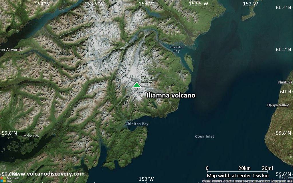
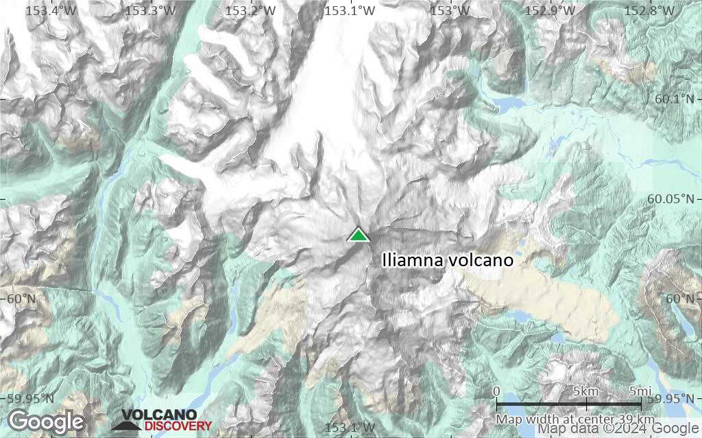
| RSS | EN | DE | EL | ES | FR | IT | RU

Iliamna Volcano

Updated: Jun 9, 2025 00:55 GMT -
stratovolcano
Cook Inlet (SW Alaska), 60.03°N / -153.09°W
Summit height: 3053 m / 10,016 ft
Current status: normal or dormant (1 out of 5)
Last update: 7 Jun 2023 (Smithsonian / USGS Weekly Volcanic Activity Report)
The summit of Iliamna volcano with active fumaroles (photo: Tina Neal, Alaska Volcano Observatory / USGS)

Iliamna volcano is a large stratovolcano on the western side of the Cook Inlet, in Lake Clark National Park 220 km SW of Anchorage or 100 km NW of Homer.
There are several uncertain reports about activity in the past 250 years, but the only confirmed known historical eruptions were small to moderate explosive eruptions in 1876, 1867, and between 778 and 1879. A larger eruption with pyroclastic flows was dated by radiocarbon method and occurred between 300 and 140 years ago, but was not observed. Most of the sparse eruption reports from Iliamna are probably referring to strong activity of fumaroles located east and SE of the summit.

[smaller] [larger]
Typical eruption style: explosive
Iliamna volcano eruptions: 1953(?), 1952(?), 1933(?), 1876, 1867, 1843(?), 1793(?), 1778-79, 1768(?)
radiocarbon-dated: 1650 ?, 450 BC ?, 2050 BC ?, 5050 BC ?

Latest nearby earthquakes

Date and TimeMag / DepthDistance / Location
Jun 8, 11:00 pm (Universal Time)
1.5

115 km
3 km (1.8 mi) to the NE Kenai Peninsula Borough, 134 mi southwest of Anchorage, Anchorage Municipality, Alaska, United States Info
Saturday, June 7, 2025 GMT (2 quakes)
Jun 7, 04:17 pm (Universal Time)
2.5

132 km
9.9 km (6.1 mi) to the NW 59 km NE of Pedro Bay, Alaska Info
Jun 7, 02:58 am (Universal Time)
1.5

106 km
13 km (7.8 mi) to the NE 66 km WNW of Happy Valley, Alaska Info
Friday, June 6, 2025 GMT (4 quakes)
Jun 6, 03:05 pm (Universal Time)
1.5

129 km
17 km (10.6 mi) to the SW 47 km ENE of Pedro Bay, Alaska Info
Jun 6, 01:50 pm (Universal Time)
1.6

103 km
29 km (18 mi) to the SE 142 mi southwest of Anchorage, Anchorage Municipality, Alaska, United States Info
Jun 6, 12:54 pm (Universal Time)
1.6

127 km
17 km (10.5 mi) to the W 48 km NE of Pedro Bay, Alaska Info
Jun 6, 01:02 am (Universal Time)
1.6

80 km
28 km (18 mi) to the E 30 mi northwest of Anchor Point, Kenai Peninsula Borough, Alaska, United States Info
Saturday, May 31, 2025 GMT (3 quakes)
May 31, 10:49 am (GMT -8)
3.4

118 km
10.2 km (6.4 mi) to the S 56 mi west of Homer, Kenai Peninsula Borough, Alaska, United States Info
May 31, 03:10 am (GMT -8)
2.4

85 km
23 km (14 mi) to the E 53 km WNW of Anchor Point, Alaska Info

Background

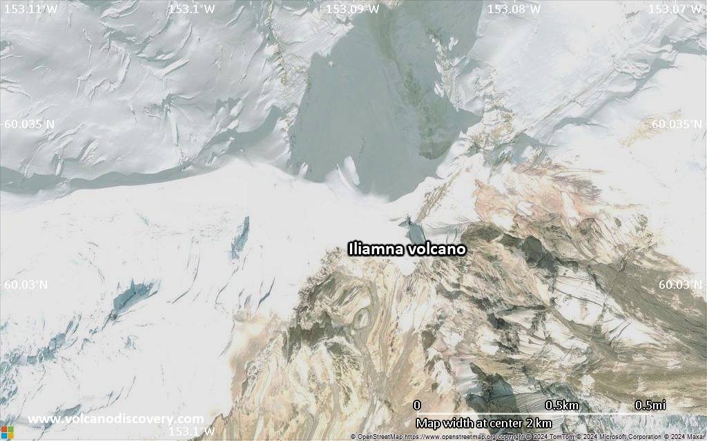
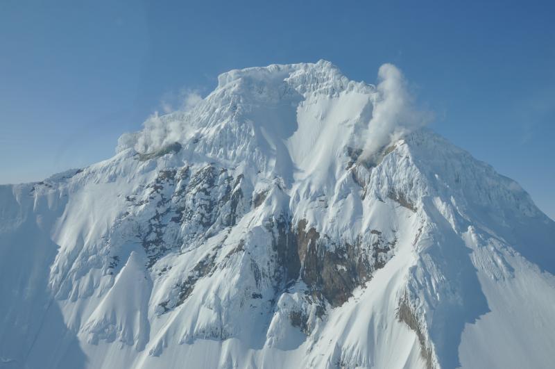
Iliamna volcano has no distinct summit crater, but forms a flat top joined on the south by a 5 km long ridge with the prominent flank lava domes of North and South Twin Peaks. Another important flank vent is the Johnson Glacier dome on the NE flank.
Steep headwalls on the southern and eastern flanks expose an inaccessible cross-section of the volcano.
Several major glaciers radiate from its summit; the 4 largest together contain an estimated volume of 15 cubic km of ice.
Eruptions producing pyroclastic flows have been dated at as recent as about 300 and 140 years ago (into the historical period), and elevated seismicity accompanying dike emplacement beneath the volcano was recorded in 1996.

Significant volcanic eruptions: Iliamna volcano

In the past 10,000 years, Iliamna has had at least 7 confirmed volcanic eruptions, out of which 3 are documented by historical records, while the others can be inferred from geological evidence.
Additionally, there are 10 uncertain or discredited eruptions from Iliamna volcano.
The table below lists all known eruptions (date in bold face) of Iliamna volcano in historic times and during the past 10,000 years. Updates on the most recent volcanic activity of Iliamna can be found on the news page of Iliamna volcano.
DateNoteVEIDeathsDamage
1987 Mar 19 - May 2
Discredited Eruption
1978 Nov 7
Discredited Eruption
?? 1953 Mar 1
Uncertain Eruption
2?
?? 1952 Jul 2 ±182 d.
Uncertain Eruption
?
?? 1947 Jun
Uncertain Eruption
?
?? 1933 May 5
Uncertain Eruption
?
1876
Historical obs./docs.
3
1867
Historical obs./docs.
2
?? 1843
Uncertain Eruption
?
?? 1793
Uncertain Eruption
?
?? 1786
Uncertain Eruption
?
1778 - 1779
Historical obs./docs.
?
?? 1768
Uncertain Eruption
?
1650 ? AD?
450 ? BC?
2050 ? BCUpper NE flank4P
5050 ? BC4P
Remark:
Our list of volcanic eruptions closely follows the database of eruptions of the Smithsonian's Global Volcanism Project (GVP), the internationally most recognized data source for volcanic eruptions, but also includes significant eruptive episodes or related volcano events. "Volcanic eruptions" are usually to be understood as sequences of individual eruptive episodes that can follow each other, or even overlap (if several vents are involved), and can last many years, decades or even longer. For example, the current activity of Stromboli volcano is understood as a single eruption that has been ongoing since 1934.
Sources: NOAA National Centers for Environmental Information (NCEI), Global Significant Volcanic Eruptions Database. doi:10.7289/V5TD9V7K | Global Volcanism Project / Smithsonian Institution

Eruptions of Iliamna volcano


1996-97 earthquake swarms
During 1996-97, dike intrusions under the volcano caused several shallow earthquake swarms, but no eruption. ...more info

1987 steam plume
On the morning of 19 March 1987 at 8am, several pilots observed an unusually large steam plume rising about 1000-1100 m above the summit of Iliamna. The plume originated from an area on the upper S flank vent, but did not contain visible ash.
The event is not counted as an eruption, but a period of exceptionally strong degassing from active fumaroles.

1978 steam eruption
A brief steam eruption occurred on 7 November 1978 between 10 and 13 h local time, producing puffs of steam, ejected every 1-5 minutes, that rose an estimated 3 km above the summit. No ash was visible in the steam puffs. No unusual seismic activity was recorded.

Iliamna Volcano FAQ

+When was the last eruption of Iliamna volcano?

+How often does Iliamna volcano erupt?

+When was the largest eruption of Iliamna volcano?

Latest satellite images

Iliamna satellite image sat1Iliamna satellite image sat2

Iliamna Volcano Maps

Below is a selection of maps showing the location and surroundings of the volcano at various resolutions based on aerial-imagery / terrain maps. Feel free to use them for non-commercial purposes on your blog or website as long as you credit them with a link back to this page (click to copy it).
Satellite/aerial-type map of Iliamna volcano (world scale)
Terrain-type map of Iliamna volcano (world scale)
Satellite/aerial-type map of Iliamna volcano (region scale large)
Terrain-type map of Iliamna volcano (region scale large)
Satellite/aerial-type map of Iliamna volcano (region scale medium)
Terrain-type map of Iliamna volcano (region scale medium)
Satellite/aerial-type map of Iliamna volcano (region scale small)
Terrain-type map of Iliamna volcano (region scale small)
Satellite/aerial-type map of Iliamna volcano (local scale large)
Terrain-type map of Iliamna volcano (local scale large)
Satellite/aerial-type map of Iliamna volcano (local scale medium)
Terrain-type map of Iliamna volcano (local scale medium)
Satellite/aerial-type map of Iliamna volcano (local scale small)
Terrain-type map of Iliamna volcano (local scale small)
Satellite/aerial-type map of Iliamna volcano (scale of 10s of km)
Terrain-type map of Iliamna volcano (scale of 10s of km)
Satellite/aerial-type map of Iliamna volcano (scale of 20-40 km)
Terrain-type map of Iliamna volcano (scale of 20-40 km)
Satellite/aerial-type map of Iliamna volcano (scale of approx. 10-20 km)
Terrain-type map of Iliamna volcano (scale of approx. 10-20 km)
Satellite/aerial-type map of Iliamna volcano (scale of 5-10 km)
Satellite/aerial-type map of Iliamna volcano (scale of few kilometers)
Volcanoes & Earthquakes - new app for Android
Guaranteed tours
1-17 Aug 2025: Volcanoes and Spices - Sulawesi/Halmahera (Indonesia)
1-14 Oct 2025: Desert, salt and volcanoes - Danakil desert (Ethiopia)
4-12 Oct 2025: From Stromboli to Etna - Sicily and Eolian Islands (Italy)
6-21 Oct 2025: From Krakatau to Bali - Java (Indonesia)
3-19 Nov 2025: Volcanoes and Spices - Sulawesi/Halmahera (Indonesia)
= spaces available   = guaranteed   = few spaces left   = booked out
Wed, 7 Jun 2023, 14:00

Iliamna volcano (Alaska Peninsula) - Smithsonian / USGS Weekly Volcanic Activity Report for 31 May-6 June 2023 (Continuing Activity)

AVO reported that seismic activity at Iliamna began to increase at around 1200 on 5 June. Initially earthquakes occurred about every one minute, then became more closely spaced. The source of the activity was possibly from movement of magma or hydrothermal fluids beneath the volcano, though similar activity had been observed before large mass movements or avalanches; AVO could not rule out either. ... Read all
Tue, 6 Jun 2023, 06:02

Iliamna volcano (Cook Inlet, SW Alaska): ice-rock avalanche followed earthquakes

Vertical-component seismic waveforms and spectrograms from AVO station ILSW for the May 2016, June 2019, and June 2023 avalanches on Iliamna volcano (image: AVO)
An elevated seismic activity occurred beneath the volcano yesterday. ... Read all

On this page:

Try our free app!
Volcanoes & Earthquakes - new app for Android
Android | iOS version

More on VolcanoDiscovery

Why is there advertising on this site?

Support us - Help us upgrade our services!

We truly love working to bring you the latest volcano and earthquake data from around the world. Maintaining our website and our free apps does require, however, considerable time and resources.
We need financing to increase hard- and software capacity as well as support our editor team. We're aiming to achieve uninterrupted service wherever an earthquake or volcano eruption unfolds, and your donations can make it happen! Every donation will be highly appreciated. If you find the information useful and would like to support our team in integrating further features, write great content, and in upgrading our soft- and hardware, please make a donation (PayPal).

Planned features:Thanks to your past donations, these features have been added recently:
Download and Upgrade the Volcanoes & Earthquakes app to get one of the fastest seismic and volcano alerts online:
Android | IOS
Thank you!
Sources: VolcanoDiscovery / VolcanoAdventures and other sources as noted.
Use of material: Most text and images on our websites are owned by us. Re-use is generally not permitted without authorization. Contact us for licensing rights.
Volcanoes & Earthquakes
VolcanoDiscovery Home
Volcanoes | Earthquakes | Photos | Volcano News | | Shop | App
Adventure & Study Travel
Tours to Volcanoes and Volcanic Areas: walking tours, photo tours, study tours
Tours & Dates | FAQ | About us
Get our newsletter!
Company info
Contact | Legal info | Terms & conditions
Follow us
Follow us on facebook Follow us on Instagram Follow us on Bluesky Follow us on Twitter Visit our Youtube channel
EN | DE | EL | ES | FR | IT | RU
VolcanoDiscovery GmbH, Germany, Reg. nr.: HRB 103744, EU Tax Id: DE 297 465 123 owned and created by
Dr. Tom Pfeiffer, volcanologist, volcano photographer, tour organizer member of
IAVCEI
IAVCEI
Vulkanologische Gesellschaft
Volcanological Society
Ecotourism Greece
Ecotourism Greece
RUV insurance
Insured by R+V
VolcanoDiscovery © 2004- All Rights Reserved | Privacy - Cookie Settings