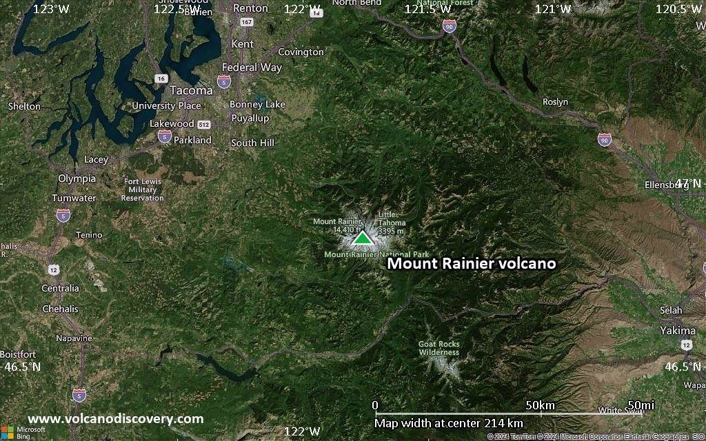
Mount Rainier Volcano
Mount Rainier, the highest peak in the Cascade Range, is located 87 km SE of Seattle and forms a majestic backdrop to the landscape of the region. The volcano is covered by 26 main glaciers, and melting of glacial ice by a future eruption causing lahars are a significant hazard for the region.
Reported 19th-century eruptions can not be verified by any deposits, but it is likely that some phreatic activity took place in 1894.
Previous eruptions have produced large debris avalanches and lahars, some of which have traveled all the way to the Pacific Ocean and reached Puget Sound.
Mount Rainier volcano eruptions: 1894, 1882(?), 1879(?), 1870(?), 1858(?), 1854(?), 1843(?), 1825(?), 300 BC, 520±200 BC, 3400 BC, 3600 BC, 3650 BC, 4400 BC, 4900 BC, 5300 BC, 5400 BC, 6800 BC
Latest nearby earthquakes
| Date and Time | Mag / Depth | Distance / Location | |||
|---|---|---|---|---|---|
| Aug 11, 07:04 pm (GMT -7) | 0.3 1.6 km | 0.7 km (0.4 mi) to the NW | Info | ||
| Aug 11, 05:25 pm (GMT -7) | 0.6 10.7 km | 13 km (7.9 mi) to the W | Info | ||
| Monday, August 11, 2025 GMT (1 quake) | |||||
| Aug 11, 04:48 pm (GMT -7) | 0.7 0.5 km | 0.6 km (0.4 mi) to the S | Info | ||
| Sunday, August 10, 2025 GMT (1 quake) | |||||
| Aug 10, 12:26 am (Universal Time) | 1.7 12 km | 19 km (12 mi) to the NW | Info | ||
| Saturday, August 9, 2025 GMT (3 quakes) | |||||
| Aug 9, 12:36 am (GMT -7) | 0.3 0.5 km | 0.6 km (0.4 mi) to the SE | Info | ||
| Aug 9, 06:40 am (Universal Time) | 0.4 3.4 km | 6.4 km (4 mi) to the SE | Info | ||
| Aug 8, 11:00 pm (GMT -7) | 0.1 7.1 km | 19 km (12 mi) to the NW | Info | ||
| Friday, August 8, 2025 GMT (1 quake) | |||||
| Aug 8, 01:00 pm (GMT -7) | 0.9 0.5 km | 17 km (10.5 mi) to the SW | Info | ||
| Saturday, August 2, 2025 GMT (1 quake) | |||||
| Aug 2, 10:05 am (Universal Time) | 1.0 1 km | 1.3 km (0.8 mi) to the N | Info | ||
Background
Mount Rainier is a typical andesitic stratovolcano. It has produced large lahars and debris avalanches. Its present summit was built within a large crater breached to the northeast formed by collapse of the volcano during a major explosive eruption about 5600 years ago, that produced the widespread Osceola Mudflow.Mt Rainier's eruptive history has been studied in detail. It includes about a dozen major eruptions during the past 2600 years, the largest of which occurred about 2200 years ago.
The present-day summit cone is cut by two overlapping craters. Extensive hydrothermal activity is present in the summit craters. It has produced melting of glacial ice created a complex system of steam caves found in the summit icecap.
Mount Rainier Volcano Photos

6 October, 2009 (Photo: volcanomike)

5 October, 2009 (Photo: volcanomike)
Significant volcanic eruptions: Mount Rainier volcano
Additionally, there are 8 uncertain or discredited eruptions from Mount Rainier volcano.
| Date | Note | VEI | Deaths | Damage | ||
|---|---|---|---|---|---|---|
?? | Uncertain Eruption Historical obs./docs. | 1 | ||||
?? | Uncertain Eruption | 2 | ||||
?? | Uncertain Eruption | 2 | ||||
?? | Uncertain Eruption | 2 | ||||
?? | Uncertain Eruption | 2 | ||||
?? | Uncertain Eruption | 2 | ||||
?? | Uncertain Eruption | 2 | ||||
Discredited Eruption | ||||||
| ? | ||||||
| ? | ||||||
| ? | ||||||
| ? | ||||||
| 4 | ||||||
| ? | ||||||
| ? | ||||||
| ? | ||||||
| ? | ||||||
| ? | ||||||
| 3 | ||||||
| 2 | ||||||
| 3 | ||||||
| ? | ||||||
Mount Rainier Volcano FAQ
+When was the last eruption of Mount Rainier volcano?
The last confirmed eruption of Mount Rainier occurred around 1450 AD.
+When was the largest eruption of Mount Rainier volcano?
The largest eruption known from the younger geological history of Mount Rainier volcano occurred around 250 BC. It only has a VEI (Volcanic Explosivity Index) of , likely because it was a mainly effusive eruption generating lava flows but very little ash.
Latest satellite images

Mount Rainier Volcano Maps