Ruapehu Volcano
Updated: Apr 28, 2024 14:27 GMT -
Stratovolcano 2797 m / 9,176 ft
North Island (New Zealand), -39.28°S / 175.57°E
Current status: normal or dormant (1 out of 5)
North Island (New Zealand), -39.28°S / 175.57°E
Current status: normal or dormant (1 out of 5)
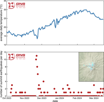
Last update: 26 Mar 2024 (series of small earthquakes)
Ruhapehu volcano
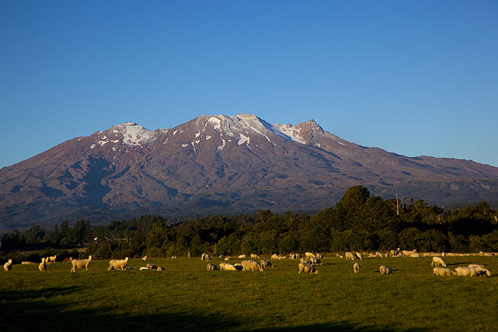
Ruapehu is one of New Zealand's most active volcanoes and forms the highest peak of the North Island. The andesitic stratovolcano has an age of around 200,000 years and contains a large summit crater containing a lake. Eruptions from the vent inside the lake often cause the lake to drain and form dangerous lahars.
[smaller] [larger]
Ruapehu volcano eruptions:
Latest nearby earthquakes
| Time | Mag. / Depth | Distance / Location | |||
| Apr 26, 02:06 pm (Auckland) | 2.0 4.4 km | 21 km (13 mi) to the NE | Info | ||
| Apr 26, 02:05 pm (Auckland) | 1.7 3.9 km | Info | |||
| Thursday, April 25, 2024 GMT (1 quake) | |||||
| Apr 26, 02:38 am (Auckland) | 1.8 11 km | Info | |||
| Wednesday, April 24, 2024 GMT (1 quake) | |||||
| Apr 24, 07:59 pm (Auckland) | 2.1 15 km | 26 km (16 mi) to the SE | Info | ||
| Monday, April 22, 2024 GMT (1 quake) | |||||
| Apr 22, 02:53 pm (Auckland) | 2.0 7.7 km | 28 km (17 mi) to the SE | Info | ||
| Thursday, April 18, 2024 GMT (1 quake) | |||||
| Apr 19, 08:43 am (Auckland) | 1.8 81 km | Info | |||
Background
Ruapehu is a complex volcanic edifice constructed over several cycles and has a NNE-SSW elongated shape. The cone is surrounded by a large plain formed by debris from flank collapse and lahar deposits.A series of very explosive (Plinian) eruptions occurred at Ruapehu between about 22,600 and 10,000 years ago. Since then, only one vent has probably been active, Crater Lake in the summit region. Activity in historic time consisted of mild explosive phreatic and phreatomagmatic eruptions often accompanied by lahars threatening the popular ski area on the volcano as well as structures in the surrounding valleys.
On 24th December 1953, a tephra dam holding in the crater lake failed passively, hence the lake drained to produce a catastrophic lahar that destroyed a rail bridge 42 km from the volcano, just as the Wellington-Auckland passenger train was crossing and fell into the valley, causing 151 fatalities.
Latest satellite images