Rungwe Volcano
Updated: Aug 2, 2025 17:06 GMT -
Stratovolcano
Tanzania, -9.13°S / 33.67°E 
Summit height: 2956 m / 9,698 ft
Current status: normal or dormant (1 out of 5)
[smaller] [larger]
Rungwe volcano eruptions: 1250 ± 40 years
Latest nearby earthquakes
| Date and Time | Mag / Depth | Distance / Location | |||
|---|---|---|---|---|---|
Background
Rungwe volcano, the largest in the Karonga basin NW of Lake Malawi (Lake Nyasa), is cut by a 4-km-wide caldera that is breached to the WSW. Hummocky terrain from a debris-avalanche deposit produced by collapse of the summit and western flank extends at least 20 km SW of the volcano. The trachytic caldera is largely filled by a series of youthful-looking uneroded and sparsely vegetated pumice cones, lava domes, and explosion craters. The latter are also found on the southern and northern flanks. A large area of basaltic cones and lava flows are found on the NW flank of the volcano, and youthful-looking lava flows extend to the SW from vents inside the caldera. Rungwe produced explosive and effusive eruptions during the Holocene; the largest explosive eruption took place about 4000 years ago and the most recent about about 1200 years ago.---
Smithsonian / GVP volcano information
Significant volcanic eruptions: Rungwe volcano
No historic eruptions are known from Rungwe volcano, but evidence from at least 3 eruptions during the past 10,000 years can be found in the geological record.
The table below lists all known eruptions (date in bold face) of Rungwe volcano in historic times and during the past 10,000 years. Updates on the most recent volcanic activity of Rungwe can be found on the news page of Rungwe volcano.
| Date | Note | VEI | Deaths | Damage | |
|---|---|---|---|---|---|
| ? | |||||
| 4 | |||||
| 5 | |||||
Remark:
Our list of volcanic eruptions closely follows the database of eruptions of the Smithsonian's Global Volcanism Project (GVP), the internationally most recognized data source for volcanic eruptions, but also includes significant eruptive episodes or related volcano events. "Volcanic eruptions" are usually to be understood as sequences of individual eruptive episodes that can follow each other, or even overlap (if several vents are involved), and can last many years, decades or even longer. For example, the current activity of Stromboli volcano is understood as a single eruption that has been ongoing since 1934.
Sources: NOAA National Centers for Environmental Information (NCEI), Global Significant Volcanic Eruptions Database. doi:10.7289/V5TD9V7K | Global Volcanism Project / Smithsonian Institution
Rungwe Volcano FAQ
+When was the last eruption of Rungwe volcano?
The last confirmed eruption of Rungwe occurred around 1250 AD.
+When was the largest eruption of Rungwe volcano?
The largest eruption known from the younger geological history of Rungwe volcano occurred in 2050 BC. It only has a VEI (Volcanic Explosivity Index) of , likely because it was a mainly effusive eruption generating lava flows but very little ash.
Latest satellite images

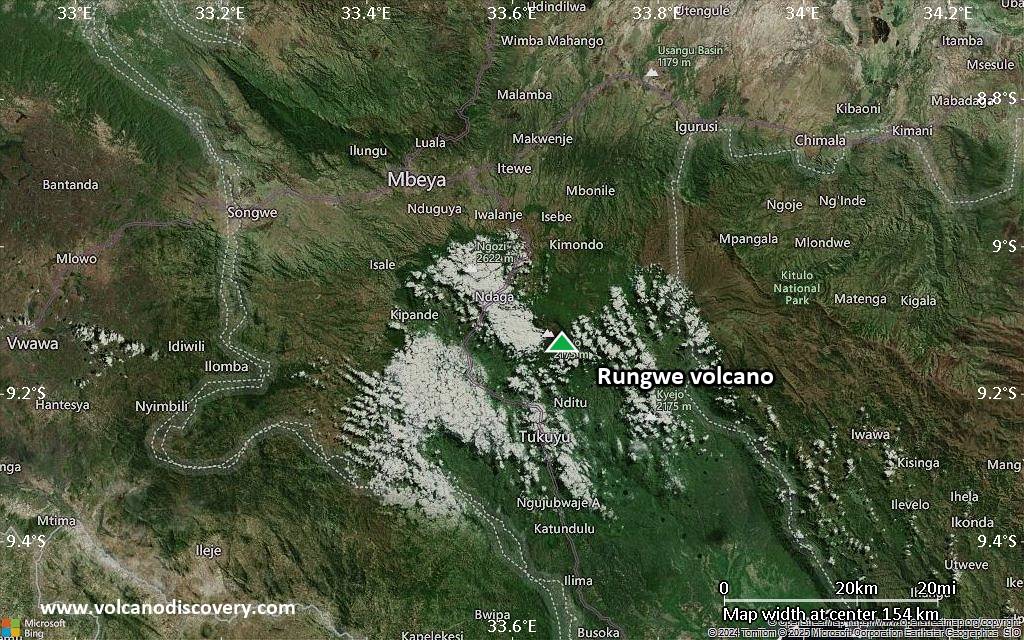
Rungwe Volcano Maps
Below is a selection of maps showing the location and surroundings of the volcano at various resolutions based on aerial-imagery / terrain maps. Feel free to use them for non-commercial purposes on your blog or website as long as you credit them with a link back to this page (click to copy it).

Satellite/aerial-type map of Rungwe volcano (world scale)

Terrain-type map of Rungwe volcano (world scale)

Satellite/aerial-type map of Rungwe volcano (region scale large)

Terrain-type map of Rungwe volcano (region scale large)

Satellite/aerial-type map of Rungwe volcano (region scale medium)

Terrain-type map of Rungwe volcano (region scale medium)

Satellite/aerial-type map of Rungwe volcano (region scale small)

Terrain-type map of Rungwe volcano (region scale small)

Satellite/aerial-type map of Rungwe volcano (local scale large)

Terrain-type map of Rungwe volcano (local scale large)

Satellite/aerial-type map of Rungwe volcano (local scale medium)

Terrain-type map of Rungwe volcano (local scale medium)
Satellite/aerial-type map of Rungwe volcano (local scale small)

Terrain-type map of Rungwe volcano (local scale small)

Satellite/aerial-type map of Rungwe volcano (scale of 10s of km)

Terrain-type map of Rungwe volcano (scale of 10s of km)

Satellite/aerial-type map of Rungwe volcano (scale of 20-40 km)

Terrain-type map of Rungwe volcano (scale of 20-40 km)

Satellite/aerial-type map of Rungwe volcano (scale of approx. 10-20 km)

Terrain-type map of Rungwe volcano (scale of approx. 10-20 km)

Satellite/aerial-type map of Rungwe volcano (scale of 5-10 km)

Satellite/aerial-type map of Rungwe volcano (scale of few kilometers)