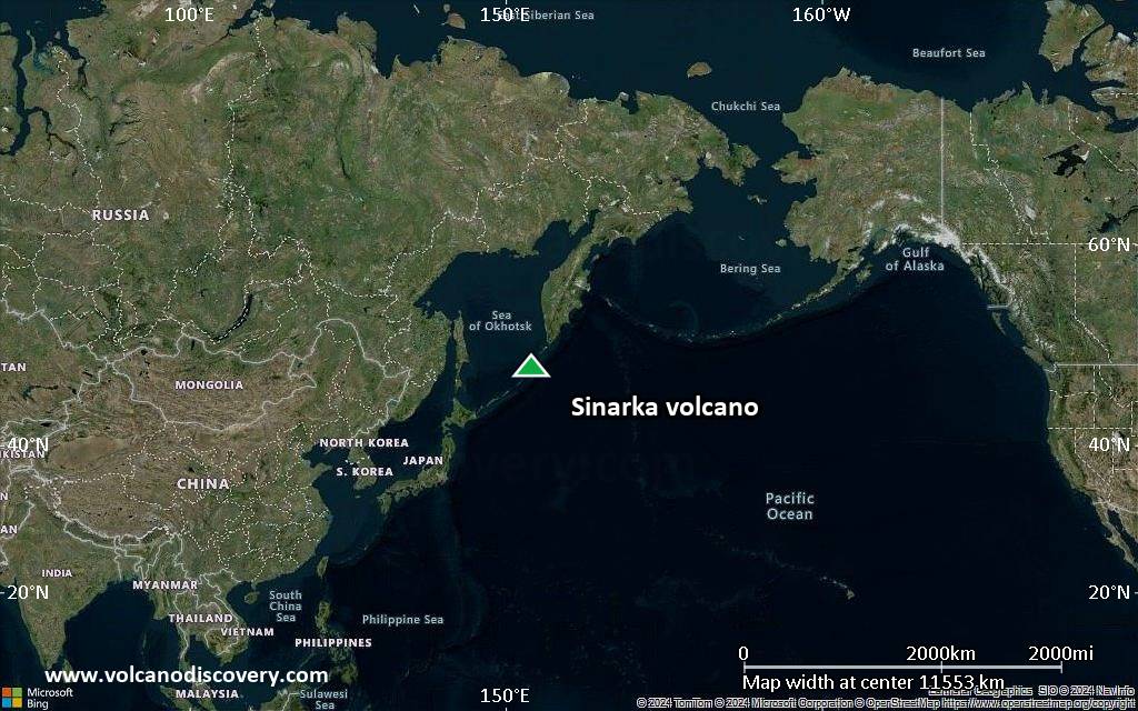
| RSS | EN | DE | EL | ES | FR | IT | RU

Sinarka Volcano

Updated: Jun 12, 2025 15:54 GMT -
stratovolcano
Central Kurile islands, Russia, 48.88°N / 154.18°E
Summit height: 934 m / 3,064 ft
Current status: normal or dormant (1 out of 5)
Last update: 17 Dec 2021

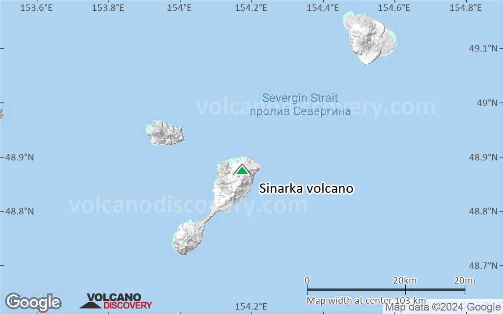
Sinarka volcano is an andesitic stratovolcano on the northern end of Shiashkotan Island in the central Kuriles, Russia. The youngest features are 2 lava domes, which have had small explosive eruptions in historic times.

[smaller] [larger]
Typical eruption style: explosive
Sinarka volcano eruptions: 1872-78, 1855, 1846, 1725

Latest nearby earthquakes

Date and TimeMag / DepthDistance / Location

Background

Sinarka has a complex structure: A small, 2-km-wide depression open to the NW has been largely filled and overtopped by an andesitic postglacial central cone that itself contains a lava dome that forms the 934 m high point of the island. Another lava dome, Zheltokamennaya Mountain, lies 1.5 km to the SW along the buried SW rim of the caldera, and a smaller dome lies along the northern caldera rim.
(Source: GVP)

Significant volcanic eruptions: Sinarka volcano

In the past 10,000 years, Sinarka has had at least 4 confirmed eruptions, all documented by historical records or observations.
There is one uncertain or discredited eruption in 2014 from Sinarka volcano.
The table below lists all known eruptions (date in bold face) of Sinarka volcano in historic times and during the past 10,000 years. Updates on the most recent volcanic activity of Sinarka can be found on the news page of Sinarka volcano.
DateNoteVEIDeathsDamage
?? 2014 Dec 3
Uncertain Eruption
Historical obs./docs.
1
1872 - 1878
Historical obs./docs.
4
1872
(eruption 1872 - 1878)
Historical obs./docs.
4100-1,000 (*)
Info
1855
Historical obs./docs.
2
1846
Historical obs./docs.
3
1725 ±25 y.
Historical obs./docs.
2?
(*) Estimated numbers
Remark:
Our list of volcanic eruptions closely follows the database of eruptions of the Smithsonian's Global Volcanism Project (GVP), the internationally most recognized data source for volcanic eruptions, but also includes significant eruptive episodes or related volcano events. "Volcanic eruptions" are usually to be understood as sequences of individual eruptive episodes that can follow each other, or even overlap (if several vents are involved), and can last many years, decades or even longer. For example, the current activity of Stromboli volcano is understood as a single eruption that has been ongoing since 1934.
Sources: NOAA National Centers for Environmental Information (NCEI), Global Significant Volcanic Eruptions Database. doi:10.7289/V5TD9V7K | Global Volcanism Project / Smithsonian Institution

Sinarka Volcano FAQ

+When was the last eruption of Sinarka volcano?

+How often does Sinarka volcano erupt?

+When was the largest eruption of Sinarka volcano?

Latest satellite images

Sinarka satellite image sat1Sinarka satellite image sat2

Sinarka Volcano Maps

Below is a selection of maps showing the location and surroundings of the volcano at various resolutions based on aerial-imagery / terrain maps. Feel free to use them for non-commercial purposes on your blog or website as long as you credit them with a link back to this page (click to copy it).
Satellite/aerial-type map of Sinarka volcano (world scale)
Terrain-type map of Sinarka volcano (world scale)
Satellite/aerial-type map of Sinarka volcano (region scale large)
Terrain-type map of Sinarka volcano (region scale large)
Satellite/aerial-type map of Sinarka volcano (region scale medium)
Terrain-type map of Sinarka volcano (region scale medium)
Satellite/aerial-type map of Sinarka volcano (region scale small)
Terrain-type map of Sinarka volcano (region scale small)
Satellite/aerial-type map of Sinarka volcano (local scale large)
Terrain-type map of Sinarka volcano (local scale large)
Satellite/aerial-type map of Sinarka volcano (local scale medium)
Terrain-type map of Sinarka volcano (local scale medium)
Satellite/aerial-type map of Sinarka volcano (local scale small)
Terrain-type map of Sinarka volcano (local scale small)
Satellite/aerial-type map of Sinarka volcano (scale of 10s of km)
Terrain-type map of Sinarka volcano (scale of 10s of km)
Satellite/aerial-type map of Sinarka volcano (scale of 20-40 km)
Terrain-type map of Sinarka volcano (scale of 20-40 km)
Satellite/aerial-type map of Sinarka volcano (scale of approx. 10-20 km)
Terrain-type map of Sinarka volcano (scale of approx. 10-20 km)
Satellite/aerial-type map of Sinarka volcano (scale of 5-10 km)
Satellite/aerial-type map of Sinarka volcano (scale of few kilometers)
Volcanoes & Earthquakes - new app for Android
Guaranteed tours
1-17 Aug 2025: Volcanoes and Spices - Sulawesi/Halmahera (Indonesia)
1-14 Oct 2025: Desert, salt and volcanoes - Danakil desert (Ethiopia)
4-12 Oct 2025: From Stromboli to Etna - Sicily and Eolian Islands (Italy)
6-21 Oct 2025: From Krakatau to Bali - Java (Indonesia)
3-19 Nov 2025: Volcanoes and Spices - Sulawesi/Halmahera (Indonesia)
= spaces available   = guaranteed   = few spaces left   = booked out
Thu, 26 Mar 2015, 17:40

Sinarka volcano (Shiashkotan Island , Kuril Islands) activity update

Satellite images showed steam-and-gas emissions from Sinarka on 16 March and a weak thermal anomaly on 21 March. ... Read all
Wed, 18 Mar 2015, 06:00

Sinarka volcano (Shiashkotan Island, Russia) - Smithsonian / USGS Weekly Volcanic Activity Report for 18 March-24 March 2015 (New Activity / Unrest)

SVERT reported that satellite images showed steam-and-gas emissions from Sinarka on 16 March and a weak thermal anomaly on 21 March. ... Read all

On this page:

Try our free app!
Volcanoes & Earthquakes - new app for Android
Android | iOS version

More on VolcanoDiscovery

Why is there advertising on this site?

Support us - Help us upgrade our services!

We truly love working to bring you the latest volcano and earthquake data from around the world. Maintaining our website and our free apps does require, however, considerable time and resources.
We need financing to increase hard- and software capacity as well as support our editor team. We're aiming to achieve uninterrupted service wherever an earthquake or volcano eruption unfolds, and your donations can make it happen! Every donation will be highly appreciated. If you find the information useful and would like to support our team in integrating further features, write great content, and in upgrading our soft- and hardware, please make a donation (PayPal).

Planned features:Thanks to your past donations, these features have been added recently:
Download and Upgrade the Volcanoes & Earthquakes app to get one of the fastest seismic and volcano alerts online:
Android | IOS
Thank you!
Sources: VolcanoDiscovery / VolcanoAdventures and other sources as noted.
Use of material: Most text and images on our websites are owned by us. Re-use is generally not permitted without authorization. Contact us for licensing rights.
Volcanoes & Earthquakes
VolcanoDiscovery Home
Volcanoes | Earthquakes | Photos | Volcano News | | Shop | App
Adventure & Study Travel
Tours to Volcanoes and Volcanic Areas: walking tours, photo tours, study tours
Tours & Dates | FAQ | About us
Get our newsletter!
Company info
Contact | Legal info | Terms & conditions
Follow us
Follow us on facebook Follow us on Instagram Follow us on Bluesky Follow us on Twitter Visit our Youtube channel
EN | DE | EL | ES | FR | IT | RU
VolcanoDiscovery GmbH, Germany, Reg. nr.: HRB 103744, EU Tax Id: DE 297 465 123 owned and created by
Dr. Tom Pfeiffer, volcanologist, volcano photographer, tour organizer member of
IAVCEI
IAVCEI
Vulkanologische Gesellschaft
Volcanological Society
Ecotourism Greece
Ecotourism Greece
RUV insurance
Insured by R+V
VolcanoDiscovery © 2004- All Rights Reserved | Privacy - Cookie Settings