| RSS | EN | DE | EL | ES | FR | IT | RU

Spurr Volcano

Updated: May 1, 2025 13:03 GMT -
stratovolcano
Cook Inlet, SW Alaska, 61.3°N / -152.25°W
Summit height: 3374 m / 11,070 ft
Current status: restless (2 out of 5)
Last update: 19 Mar 2025 (Smithsonian / USGS Weekly Volcanic Activity Report)

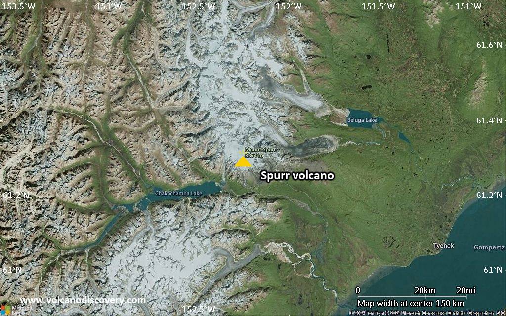
Mt Spurr volcano is the highest volcano in the Aleutian Volcanic Arc. the glacier-covered stratovolcano is located 130 km west of Anchorage and NE of Chakachamna Lake.
Mt Spurr had a violent sub-plinian eruption in 1992 and a large eruption in 1953, both ranking at VEI 4 and produced by Crater Peak, a small flank vent on the south side. No other historic eruptions have been documented.

[smaller] [larger]
Typical eruption style: explosive
Spurr volcano eruptions: 1992 (Crater Peak), 1965 (?, Spurr), 1953 (Crater Peak)
tephrochronology and radiocarbon dated: 1650 ± 50 years, 3250 BC ?, 4050 BC ?, 5110 BC ± 100 years, 6050 BC

Latest nearby earthquakes

Date and TimeMag / DepthDistance / Location
Apr 30, 08:08 pm (Universal Time)
0.0

2.4 km
2 km (1.2 mi) to the S 64 km WNW of Tyonek, Alaska Info
Apr 30, 04:49 pm (Universal Time)
0.9

0 km
4.1 km (2.6 mi) to the E 61 km WNW of Beluga, Alaska Info
Apr 30, 03:29 pm (Universal Time)
0.3

10.1 km
18 km (11 mi) to the SW 75 km W of Tyonek, Alaska Info
Apr 30, 09:13 am (Universal Time)
0.3

4 km
11 km (6.9 mi) to the S 64 km WNW of Tyonek, Alaska Info
Tuesday, April 29, 2025 GMT (1 quake)
Apr 29, 02:27 am (Universal Time)
0.4

2.1 km
2.9 km (1.8 mi) to the N 65 km WNW of Beluga, Alaska Info
Monday, April 28, 2025 GMT (2 quakes)
Apr 28, 07:44 pm (Universal Time)
0.1

2.8 km
2.3 km (1.4 mi) to the S Southern Alaska Info
Apr 28, 06:21 am (Universal Time)
0.1

16 km
10.7 km (6.7 mi) to the SE 55 km WNW of Tyonek, Alaska Info
Friday, April 25, 2025 GMT (2 quakes)
Apr 25, 08:18 am (Universal Time)
1.4

95 km
20 km (13 mi) to the SE 45 km WNW of Tyonek, Alaska Info
Apr 25, 03:59 am (Universal Time)
1.3

87 km
23 km (14 mi) to the NE 49 km WNW of Beluga, Alaska Info

Background

The 3374-m-high summit of Mount Spurr, the highest volcano of the Aleutain arc, is a large lava dome constructed at the center of a roughly 5-km-wide horseshoe-shaped caldera that is open to the south.
The caldera was formed by a late-Pleistocene or early Holocene debris avalanche and associated pyroclastic flows that destroyed an ancestral Spurr volcano. The debris avalanche traveled more than 25 km to the SE, and the resulting deposit contains blocks as large as 100 m in diameter. Several ice-carved post-caldera cones or lava domes lie in the center of the caldera. The youngest vent, 2309-m-high Crater Peak, formed at the breached southern end of the caldera and has been the source of about 40 identified Holocene tephra layers. Spurr's two historical eruptions, from Crater Peak in 1953 and 1992, deposited ash on the city of Anchorage.
---
from: Smithsonian / GVP Mt Spurr volcano information

Significant volcanic eruptions: Spurr volcano

In the past 10,000 years, Spurr has had at least 7 confirmed volcanic eruptions, out of which 2 are documented by historical records, while the others can be inferred from geological evidence.
There is one uncertain or discredited eruption in 1954 from Spurr volcano.
The table below lists all known eruptions (date in bold face) of Spurr volcano in historic times and during the past 10,000 years. Updates on the most recent volcanic activity of Spurr can be found on the news page of Spurr volcano.
DateNoteVEIDeathsDamage
1992 Jun 27 - Sep 17South flank (Crater Peak)
Historical obs./docs.
4
1992 Sep 17
(eruption 1992 Jun 27 - Sep 17)
Historical obs./docs.
41
light
Info
1954 Jul 2 ±182 d.
Discredited Eruption
1953 Jul 9 - Jul 16South flank (Crater Peak)
Historical obs./docs.
4
1650 ±50 y. ADSouth flank (Crater Peak)?
3250 ? BCMt. Spurr central lava/cone complex?
4050 ? BCSouth flank (Crater Peak)?
5110 ±100 y. BCMt. Spurr central dome/cone complex?
6050 ? BCMt. Spurr central dome/cone complex?
Remark:
Our list of volcanic eruptions closely follows the database of eruptions of the Smithsonian's Global Volcanism Project (GVP), the internationally most recognized data source for volcanic eruptions, but also includes significant eruptive episodes or related volcano events. "Volcanic eruptions" are usually to be understood as sequences of individual eruptive episodes that can follow each other, or even overlap (if several vents are involved), and can last many years, decades or even longer. For example, the current activity of Stromboli volcano is understood as a single eruption that has been ongoing since 1934.
Sources: NOAA National Centers for Environmental Information (NCEI), Global Significant Volcanic Eruptions Database. doi:10.7289/V5TD9V7K | Global Volcanism Project / Smithsonian Institution

Eruptions of Spurr volcano


1992 eruption
A large, subplinian eruption occurred in 1992 at Mt Spurr volcano. There were 3 main explosions, on 27 June, 18 August and 16-17 September. The eruption produced ash columns up to 13.5 km high and ashfall in several hundred km distance. ...more info

1953 eruption
A VEI 4 explosive eruption occurred at Crater Peak from 9-16 July 1953. It produced major ash fall (up to 6 mm in Anchorage) and lahars on the flanks and the base of the volcano.

Spurr Volcano FAQ

+When was the last eruption of Spurr volcano?

+How often does Spurr volcano erupt?

+How active is Spurr volcano at present?

+When was the largest eruption of Spurr volcano?

Latest satellite images

Spurr satellite image sat1Spurr satellite image sat2

Spurr Volcano Maps

Below is a selection of maps showing the location and surroundings of the volcano at various resolutions based on aerial-imagery / terrain maps. Feel free to use them for non-commercial purposes on your blog or website as long as you credit them with a link back to this page (click to copy it).
Satellite/aerial-type map of Spurr volcano (world scale)
Terrain-type map of Spurr volcano (world scale)
Satellite/aerial-type map of Spurr volcano (region scale large)
Terrain-type map of Spurr volcano (region scale large)
Satellite/aerial-type map of Spurr volcano (region scale medium)
Terrain-type map of Spurr volcano (region scale medium)
Satellite/aerial-type map of Spurr volcano (region scale small)
Terrain-type map of Spurr volcano (region scale small)
Satellite/aerial-type map of Spurr volcano (local scale large)
Terrain-type map of Spurr volcano (local scale large)
Satellite/aerial-type map of Spurr volcano (local scale medium)
Terrain-type map of Spurr volcano (local scale medium)
Satellite/aerial-type map of Spurr volcano (local scale small)
Terrain-type map of Spurr volcano (local scale small)
Satellite/aerial-type map of Spurr volcano (scale of 10s of km)
Terrain-type map of Spurr volcano (scale of 10s of km)
Satellite/aerial-type map of Spurr volcano (scale of 20-40 km)
Terrain-type map of Spurr volcano (scale of 20-40 km)
Satellite/aerial-type map of Spurr volcano (scale of approx. 10-20 km)
Terrain-type map of Spurr volcano (scale of approx. 10-20 km)
Satellite/aerial-type map of Spurr volcano (scale of 5-10 km)
Satellite/aerial-type map of Spurr volcano (scale of few kilometers)
Volcanoes & Earthquakes - new app for Android
Guaranteed tours
9-25 Jun 2025: Volcanoes and Spices - Sulawesi/Halmahera (Indonesia)
7-22 Jul 2025: From Krakatau to Bali - Java (Indonesia)
7-23 Jul 2025: Volcanoes and Spices - Sulawesi/Halmahera (Indonesia)
1-17 Aug 2025: Volcanoes and Spices - Sulawesi/Halmahera (Indonesia)
1-14 Oct 2025: Desert, salt and volcanoes - Danakil desert (Ethiopia)
4-12 Oct 2025: From Stromboli to Etna - Sicily and Eolian Islands (Italy)
6-21 Oct 2025: From Krakatau to Bali - Java (Indonesia)
3-19 Nov 2025: Volcanoes and Spices - Sulawesi/Halmahera (Indonesia)
= spaces available   = guaranteed   = few spaces left   = booked out
Wed, 19 Mar 2025, 15:00

Spurr volcano (United States) - Smithsonian / USGS Weekly Volcanic Activity Report for 12 March-18 March 2025 (Continuing Activity)

The Alaska Volcano Observatory (AVO) reported increasing unrest at Spurr in a special information statement issued on 12 March. Collapses of snow and ice into the summit crater lake that formed during the current period of unrest continued to occur along with steam emissions from fumaroles within and around the summit crater. New diffuse steam plumes from small snow-free spots within Crater Peak, a vent 3.5 km S of the summit, were first observed on 6 March. ... Read all
Thu, 13 Mar 2025, 11:00

Spurr volcano (United States) - Smithsonian / USGS Weekly Volcanic Activity Report for 12 March-18 March 2025 (Continuing Activity)

The Alaska Volcano Observatory (AVO) reported increasing unrest at Spurr in a special information statement issued on 12 March. Collapses of snow and ice into the summit crater lake that formed during the current period of unrest continued to occur along with steam emissions from fumaroles within and around the summit crater. New diffuse steam plumes from small snow-free spots within Crater Peak, a vent 3.5 km S of the summit, were first observed on 6 March. ... Read all
Location map of Spurr Volcano, Cook Inlet region, Alaska (courtesy of Janet Schaefer, Alaska Volcano Observatory / USGS)

On this page:

Try our free app!
Volcanoes & Earthquakes - new app for Android
Android | iOS version

More on VolcanoDiscovery

Why is there advertising on this site?

Support us - Help us upgrade our services!

We truly love working to bring you the latest volcano and earthquake data from around the world. Maintaining our website and our free apps does require, however, considerable time and resources.
We need financing to increase hard- and software capacity as well as support our editor team. We're aiming to achieve uninterrupted service wherever an earthquake or volcano eruption unfolds, and your donations can make it happen! Every donation will be highly appreciated. If you find the information useful and would like to support our team in integrating further features, write great content, and in upgrading our soft- and hardware, please make a donation (PayPal).

Planned features:Thanks to your past donations, these features have been added recently:
Download and Upgrade the Volcanoes & Earthquakes app to get one of the fastest seismic and volcano alerts online:
Android | IOS
Thank you!
Sources: VolcanoDiscovery / VolcanoAdventures and other sources as noted.
Use of material: Most text and images on our websites are owned by us. Re-use is generally not permitted without authorization. Contact us for licensing rights.
Volcanoes & Earthquakes
VolcanoDiscovery Home
Volcanoes | Earthquakes | Photos | Volcano News | | Shop | App
Adventure & Study Travel
Tours to Volcanoes and Volcanic Areas: walking tours, photo tours, study tours
Tours & Dates | FAQ | About us
Get our newsletter!
Company info
Contact | Legal info | Terms & conditions
Follow us
Follow us on facebook Follow us on Instagram Follow us on Bluesky Follow us on Twitter Visit our Youtube channel
EN | DE | EL | ES | FR | IT | RU
VolcanoDiscovery GmbH, Germany, Reg. nr.: HRB 103744, EU Tax Id: DE 297 465 123 owned and created by
Dr. Tom Pfeiffer, volcanologist, volcano photographer, tour organizer member of
IAVCEI
IAVCEI
Vulkanologische Gesellschaft
Volcanological Society
Ecotourism Greece
Ecotourism Greece
RUV insurance
Insured by R+V
VolcanoDiscovery © 2004- All Rights Reserved | Privacy - Cookie Settings