| RSS | EN | DE | EL | ES | FR | IT | RU

Telica Volcano

Updated: Jul 29, 2025 21:14 GMT -
Stratovolcano(es)
Nicaragua, 12.6°N / -86.85°W
Summit height: 1061 m / 3,481 ft
Current status: minor activity or eruption warning (3 out of 5)
Last update: 26 Jul 2025 (Volcanic Ash Advisory)
Telica volcano (image: GVP)

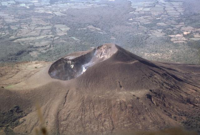
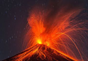
Telica, one of the most active volcanoes in Nicaragua, is a group of overlapping cones and craters on a broad NW line. The most prominent vent is a 700 m wide and 120 m deep double crater at the summit. Its southern summit crater has been the source of Telica's recent eruptions.
The older Santa Clara vent at the SW end of the edifice erupted in 16th century and is now covered with vegetation. Another vent El Liston, immediately SE of Telica, is another volcanic edifice with several nested craters.
Fumaroles and boiling mudpots are found at Hervideros de San Jacinto, SE of Telica. This prominent geothermal area is popular among tourists and the site of nearby geothermal exploration.

[smaller] [larger]
Typical eruption style: explosive
Telica volcano eruptions: 2016, 2015, 2013, 2011, 2007, 2006, 2004, 1999-2000, 1994, 1987, 1981-82, 1981, 1976-78, 1975-76, 1969-71, 1966, 1965, 1962, 1951, 1948-49, 1946, 1943-44, 1941(?), 1940, 1939, 1939, 1937-38, 1934, 1929, 1928, 1927, 1918(?), 1907, 1791, 1765, 1743(?), 1685, 1613, 1529, 1527(?)

Latest nearby earthquakes

Date and TimeMag / DepthDistance / Location
Jul 17, 12:38 pm (Universal Time)
0.0

1 km
16 km (9.8 mi) to the N 30 km northeast of Chinandega, Departamento de Chinandega, Nicaragua Info
Jul 17, 06:38 am (GMT -6)
1.8

1 km
13 km (8.4 mi) to the NW 21 km east of Chinandega, Departamento de Chinandega, Nicaragua Info

Significant volcanic eruptions: Telica volcano

In the past 10,000 years, Telica has had at least 46 confirmed eruptions, all documented by historical records or observations. Additionally, there are 6 uncertain or discredited eruptions from Telica volcano.
The table below lists all known eruptions (date in bold face) of Telica volcano since around 1900. Updates on the most recent volcanic activity of Telica can be found on the news page of Telica volcano.
DateNoteVEIDeathsDamage
2021 Apr 21 - 2022 Mar 29
Historical obs./docs.
1
2020 Jul 20 - Dec 9
Historical obs./docs.
1
2018 Jun 21 - Aug 15
Historical obs./docs.
1
2015 Sep 23 - 2016 May 11Telica crater
Historical obs./docs.
2
2015 May 7 - May 28Telica crater
Historical obs./docs.
2
2013 Sep 25Telica crater
Historical obs./docs.
1
2011 Mar 7 - Jun 14Southern crater
Historical obs./docs.
2
2008 Jul 5 ±4 d.
Historical obs./docs.
1
2007 Oct 28 ±3 d. - 2008 Feb 18
Historical obs./docs.
1?
?? 2007 Jun 12
Uncertain Eruption
1
2006 Dec 11 ? - 2007 Feb 17
Historical obs./docs.
1
2006 Aug 4 - Aug 6
Historical obs./docs.
1
2004 Nov 5 - 2005 Jan 29
Historical obs./docs.
1
2004 Mar 31
Historical obs./docs.
1
2002 Oct 17
Historical obs./docs.
0
2001 Jan 17 - Dec 19 ?
Historical obs./docs.
1
1999 May 21 - 2000 Sep 6
Historical obs./docs.
2
1994 Jul 31 - Aug 12
Historical obs./docs.
2
1987 Nov 16 ±15 d.Vent in NE corner of crater
Historical obs./docs.
1
1981 Nov 25 ±5 d. - 1982 Mar 2
Historical obs./docs.
2
1981 Feb 16 ±15 d.
Historical obs./docs.
1
1976 Nov 3 - 1978 Jan 16 ±15 d.
Historical obs./docs.
1
1975 May 16 ±15 d. - 1976 Mar 16 ±15 d.
Historical obs./docs.
0
1969 Feb 11 - 1971 Dec 16 ±15 d.
Historical obs./docs.
2
1966 Jun 16 ±15 d.
Historical obs./docs.
1
1965 Jan 16 - Jan 28
Historical obs./docs.
1
1962 Jan 16 ±15 d.
Historical obs./docs.
1
1951 Jul 15 ±45 d. - Oct 15 ±5 d.
Historical obs./docs.
2
1948 Jun - 1949 Nov
Historical obs./docs.
2
1948 Jan
Historical obs./docs.
2
1946 Apr - Aug
Historical obs./docs.
2
1943 Dec - 1944 Apr
Historical obs./docs.
2
?? 1941
Uncertain Eruption
?
1940 Jun - Oct
Historical obs./docs.
2
1939 Nov
Historical obs./docs.
2
1939 Jan - Jun
Historical obs./docs.
2
1937 Nov - 1938 Aug
Historical obs./docs.
2
1934 Jan
Historical obs./docs.
2
1929 Jan
Historical obs./docs.
1?
1928
Historical obs./docs.
2
1927 Aug - Nov
Historical obs./docs.
2
?? 1919 Oct 26 ±5 d.
Uncertain Eruption
2?
?? 1918 Jan
Uncertain Eruption
2?
1907 Nov
Historical obs./docs.
2
Remark:
Our list of volcanic eruptions closely follows the database of eruptions of the Smithsonian's Global Volcanism Project (GVP), the internationally most recognized data source for volcanic eruptions, but also includes significant eruptive episodes or related volcano events. "Volcanic eruptions" are usually to be understood as sequences of individual eruptive episodes that can follow each other, or even overlap (if several vents are involved), and can last many years, decades or even longer. For example, the current activity of Stromboli volcano is understood as a single eruption that has been ongoing since 1934.
Sources: NOAA National Centers for Environmental Information (NCEI), Global Significant Volcanic Eruptions Database. doi:10.7289/V5TD9V7K | Global Volcanism Project / Smithsonian Institution

Eruptions of Telica volcano


2007 eruptions: ash emissions
In January and February 2007, there were small ash eruptions producing ash clouds reaching altitudes of 5000 ft (1,8 km).

1999-2000 eruptions
Telica volcano became active in August 1999. On 10 August 1999, an eruption produced ash fall 20 km WSW of Telica in the city of Chichigalpa.
A lava lake in the summit crater was observed on 18 August. The ash eruptions continued until February 2000 and declined afterwards.

Telica Volcano FAQ

+When was the last eruption of Telica volcano?

+How often does Telica volcano erupt?

+How active is Telica volcano at present?

+When was the largest eruption of Telica volcano?

Latest satellite images

Telica satellite image sat1Telica satellite image sat2

Telica Volcano Maps

Below is a selection of maps showing the location and surroundings of the volcano at various resolutions based on aerial-imagery / terrain maps. Feel free to use them for non-commercial purposes on your blog or website as long as you credit them with a link back to this page (click to copy it).
Satellite/aerial-type map of Telica volcano (world scale)
Terrain-type map of Telica volcano (world scale)
Satellite/aerial-type map of Telica volcano (region scale large)
Terrain-type map of Telica volcano (region scale large)
Satellite/aerial-type map of Telica volcano (region scale medium)
Terrain-type map of Telica volcano (region scale medium)
Satellite/aerial-type map of Telica volcano (region scale small)
Terrain-type map of Telica volcano (region scale small)
Satellite/aerial-type map of Telica volcano (local scale large)
Terrain-type map of Telica volcano (local scale large)
Satellite/aerial-type map of Telica volcano (local scale medium)
Terrain-type map of Telica volcano (local scale medium)
Satellite/aerial-type map of Telica volcano (local scale small)
Terrain-type map of Telica volcano (local scale small)
Satellite/aerial-type map of Telica volcano (scale of 10s of km)
Terrain-type map of Telica volcano (scale of 10s of km)
Satellite/aerial-type map of Telica volcano (scale of 20-40 km)
Terrain-type map of Telica volcano (scale of 20-40 km)
Satellite/aerial-type map of Telica volcano (scale of approx. 10-20 km)
Terrain-type map of Telica volcano (scale of approx. 10-20 km)
Satellite/aerial-type map of Telica volcano (scale of 5-10 km)
Satellite/aerial-type map of Telica volcano (scale of few kilometers)
Volcanoes & Earthquakes - new app for Android
Guaranteed tours
1-17 Aug 2025: Volcanoes and Spices - Sulawesi/Halmahera (Indonesia)
1-14 Oct 2025: Desert, salt and volcanoes - Danakil desert (Ethiopia)
4-12 Oct 2025: From Stromboli to Etna - Sicily and Eolian Islands (Italy)
6-21 Oct 2025: From Krakatau to Bali - Java (Indonesia)
3-19 Nov 2025: Volcanoes and Spices - Sulawesi/Halmahera (Indonesia)
9-19 Nov 2025: Guatemala Volcano Special - Guatemala
= spaces available   = guaranteed   = few spaces left   = booked out

On this page:

Try our free app!
Volcanoes & Earthquakes - new app for Android
Android | iOS version

More on VolcanoDiscovery

Why is there advertising on this site?

Support us - Help us upgrade our services!

We truly love working to bring you the latest volcano and earthquake data from around the world. Maintaining our website and our free apps does require, however, considerable time and resources.
We need financing to increase hard- and software capacity as well as support our editor team. We're aiming to achieve uninterrupted service wherever an earthquake or volcano eruption unfolds, and your donations can make it happen! Every donation will be highly appreciated. If you find the information useful and would like to support our team in integrating further features, write great content, and in upgrading our soft- and hardware, please make a donation (PayPal).

Planned features:Thanks to your past donations, these features have been added recently:
Download and Upgrade the Volcanoes & Earthquakes app to get one of the fastest seismic and volcano alerts online:
Android | IOS
Thank you!
Sources: VolcanoDiscovery / VolcanoAdventures and other sources as noted.
Use of material: Most text and images on our websites are owned by us. Re-use is generally not permitted without authorization. Contact us for licensing rights.
Volcanoes & Earthquakes
VolcanoDiscovery Home
Volcanoes | Earthquakes | Photos | Volcano News | | Shop | App
Adventure & Study Travel
Tours to Volcanoes and Volcanic Areas: walking tours, photo tours, study tours
Tours & Dates | FAQ | About us
Get our newsletter!
Company info
Contact | Legal info | Terms & conditions
Follow us
Follow us on facebook Follow us on Instagram Follow us on Bluesky Follow us on Twitter Visit our Youtube channel
EN | DE | EL | ES | FR | IT | RU
VolcanoDiscovery GmbH, Germany, Reg. nr.: HRB 103744, EU Tax Id: DE 297 465 123 owned and created by
Dr. Tom Pfeiffer, volcanologist, volcano photographer, tour organizer member of
IAVCEI
IAVCEI
Vulkanologische Gesellschaft
Volcanological Society
Ecotourism Greece
Ecotourism Greece
RUV insurance
Insured by R+V
VolcanoDiscovery © 2004- All Rights Reserved | Privacy - Cookie Settings