(pyroclastic cone 1000 m / 3281 ft)
The Aluchin volcanic group is a cluster of 4 young cinder cones located in the Bilibino Region, in the Aluchin and Burgakhchan river basins in western Chukotka (Siberia). The cinder cones of Aluchin volcano could have erupted less than 10,000 years ago. [
more info]
(pyroclastic cones 1050 m / 3,445 ft)
Anjuisky volcano is a cinder cone in the south Anjuisky Range east of Kolyma River. Anjuisky cinder cone is 120 m high and has a 300 m wide and 75 m deep crater. [
more info]
(volcanic field 2765 m / 9,071 ft)
The Azas Plateau (also known as the (Northeast) Tuva or Khamsara-Biykhem Plateau) is a large volcanic field is west of the SW tip of Lake Baikal and north of the border with Mongolia. The volcanic field contains cinder cones and lava flows, some of which are less than 10,000 year... [
more info]
(cinder cone 993 m / 3,258 ft)
Balagan-Tas volcano (also known as Indigirsky) is a cinder cone west of the town Zashiversk, about 1300 km SSW of Bennet Island in Siberia. It is located at the Indikirika River near the northwest boundary of Momo-Selenniak depression.
The volcano erupted basaltic lava flow... [
more info]
(cinder cones 1500 m / 4,921 ft)
Dgida volcano (Dgida Basin, Dgida-Tunkin volcanic field) is a group of cinder cones in southeastern Russia 23 km from the border with Mongolia and 125 km SW of Lake Baikal. It belongs to the Tunkin Depression volcanic field and is considered to be related to an intraplate hot spo... [
more info]
(stratovolcano 5633 m / 18,481 ft)
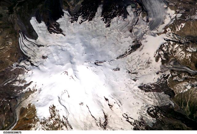
Glaciers radiate from Mount Elbrus, the highest peak of the Caucasus Mountains of SW Russia. Snow-filled craters are visible in this image at both the 5595-m-high eastern summit and the 5633-m-high western summit. Image courtesy of Earth Sciences and Image Analysis Laboratory, NASA Johnson Space Center, 2002
Elbrus volcano is a large stratovolcano in the western Caucasus of SW Russia. It is the highest mountain of Europe (although some argue that it belongs already to Asia) and the highest volcano of the northern hemisphere.
Elbrus has not erupted for about 2000 years, but is c... [
more info]
(Volcanic field 2369 m / 7772 ft)
[
more info]
(cinder cones 2,077 m / 6,814 ft)
Oka Plateau volcano (also known as the East Sayan volcanic field, East Sayan Volcanic Field, Oka Plateau, Zhom-Bolok, or Jom-Bolok volcano) is a a group of small basaltic cinder cones and associated lava flows in SE Russia near the border with Mongolia, about 200 km west of Lake ... [
more info]
(volcanic field unknown summit elevation)
Sikhote-Alin volcano is a vast cluster of basaltic fissure vents in the Sikhote-Alin region of SE Russia near the Sea of Japan, NE of Vladivostok.
Large basalts and basaltic-andesites lava flows cover several 1000 square km. [
more info]
(volcanic field 1200? m / 3,937 ft)
Tunkin (also known as Tunka) volcano is a volcanic field immediately west of the SW tip of Lake Baikal. It contains 5 groups of basaltic cinder cones, most prominently the Khobok cinder cones near the village of Tunka.
The youngest cones occur in the SE part of the field in... [
more info]
(pyroclastic cones 2180 m / 7,152 ft)
The Udokan Plateau volcano is a volcanic field located in southeastern Russia 400 km ENE of the Baikal Lake. The field contains cinder cones, lava domes, lava flows and explosion craters (maars).
The latest eruption took place at Chepe volcano about 2200 years ago. [
more info]
(cinder cones 1250 m / 4,101 ft)
The Vitim Plateau volcano is a vast volcanic field northeast of the Baikal Lake. Cinder cones and associated lava flows are spread over an area of about 10,000 sq km. [
more info]
(Stratovolcano(es) 2319 m / 7608 ft)
[
more info]
(Stratovolcanoes 1180 m / 3,871 ft)
[
more info]
(Shield volcano 1956 m / 6,417 ft)
[
more info]
(Stratovolcano 2598 m / 8,524 ft)
[
more info]
(Stratovolcano 1853 m / 6,079 ft)
[
more info]
(Stratovolcano 1828 m / 5,997 ft)
[
more info]
(Stratovolcano 2741 m (8,993 ft))
The summit cone of Avachinsky volcano seen from the outer western caldera slope in August 2024 (image: Marina Morozova)
Avachinsky towering above Petropavlovsk, Kamchatka's largest city, is one of Kamchatka's most active volcanoes. It typically erupts every few years to decades, often producing ash flows and lahars. [
more info]
(Stratovolcano 2278 m / 7,474 ft)

Bakening volcano seen from the west in Sep 2024 (image: Marina Morozova)
[
more info]
(Shield volcanoes 2080 m / 6,824 ft)
[
more info]
(Stratovolcano 1244 m / 4,081 ft)
[
more info]
(Shield volcanoes 1906 m / 6,253 ft)
[
more info]
(Stratovolcanoes 1720 m / 5,643 ft)
[
more info]
(Shield volcanoes 1401 m / 4,596 ft)
[
more info]
(Stratovolcano 1778 m / 5,833 ft)
[
more info]
(Pyroclastic cones 1868 m / 6,129 ft)
[
more info]
(Compound volcano 2285 m / 7,497 ft)
[
more info]
(Shield volcano 1046 m / 3,432 ft)
[
more info]
(Shield volcanoes 1381 m / 4,531 ft)
[
more info]
(Shield volcano 965 m / 3,166 ft)
[
more info]
(Complex volcano 2576 m / 8,451 ft)
[
more info]
(Shield volcano 1170 m / 3,839 ft)
[
more info]
(Stratovolcano (caldera) 1829 m (6,001 ft))
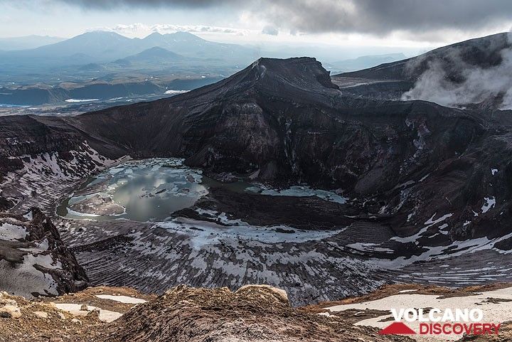
The eastern central crater of Gorely, often filled with an acid lake.
Gorely volcano is one of the most active volcanoes in southern Kamchatka and located 75 km SW of Petropavlovsk. It is a complex of several overlapping stratovolcanoes with many summit and flank craters. Activity in historic times were mainly small to medium-sized ash and steam er... [
more info]
(Stratovolcano 2125 m / 6,972 ft)
[
more info]
(Stratovolcano 3621 m / 11,880 ft)
[
more info]
(Shield volcanoes 1340 m / 4,396 ft)
[
more info]
(Shield volcanoes 2300? m / 7,546 ft)
[
more info]
(Shield volcano 1582 m / 5,190 ft)
[
more info]
(Stratovolcano 1536 m / 5,039 ft)
Karymsky is the most active volcano of Kamchatka's eastern volcanic zone and a perfect symmetrical stratovolcano. Ash eruptions from Karymski can come in the way of aircraft flight routes across the N Pacific. Karymsky, the most active volcano of Kamchatka's eastern volcanic zone... [
more info]
(Shield volcano 1527 m / 5,010 ft)
[
more info]
(Shield volcanoes 1377 m / 4,518 ft)
[
more info]
(Stratovolcano 2000 m / 6,562 ft)
[
more info]
(Stratovolcanoes 1552 m / 5,092 ft)
[
more info]
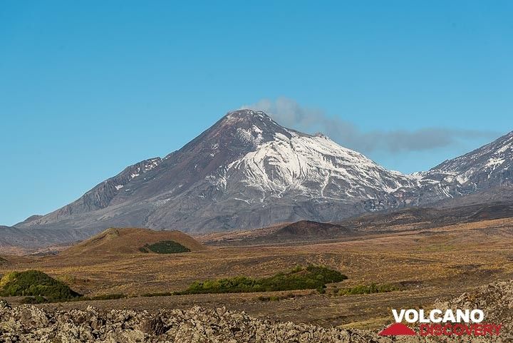
(stratovolcano 2376 m / 7,795 ft)
Kizimen volcano is an isolated, conical stratovolcano located in the Shchapina graben on the SE margin of the Central Kamchatkan Valley. After almost a century of quiet, it started to become restless in 2009 and erupt in late 2010. The new ongoing eruption has been building a new... [
more info]
(Stratovolcano 2070 m / 6,791 ft)
[
more info]
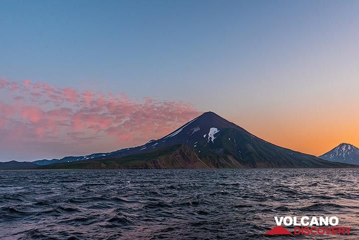
(stratovolcano 3456 m ( 11,338 ft))
View of Koryasky volcano rising in the background
Koryaksky in the SE of the Kamchatka peninsula and near its capital Petropavlovsk is one of Kamchatka's most beautiful and prominent stratovolcanoes. [
more info]
(Shield volcano 2016 m / 6,614 ft)
[
more info]
(Shield volcano 1554 m / 5,098 ft)
[
more info]
(Stratovolcano 3528 m / 11,575 ft)
[
more info]
(Shield volcano 915 m / 3,002 ft)
[
more info]
(Shield volcano 1333 m / 4,373 ft)
[
more info]
(Stratovolcano(es) 1858 m / 6096 ft)
[
more info]
(Shield volcanoes 1802 m / 5,912 ft)
[
more info]
(Shield volcano 1641 m / 5,384 ft)
[
more info]
(Shield volcanoes 1764 m / 5,787 ft)
[
more info]
(Stratovolcano 2552 m / 8,373 ft)
[
more info]
(Submarine volcano -300 m / - 984 ft)
[
more info]
Piip (Kamchatka)
(shield volcano 2,059 m / 6,755 ft)
Piip is a Pleistocene shield-like volcano in eastern Kamchatka.
(Shield volcano 1255 m / 4,117 ft)
[
more info]
(Shield volcano 1236 m / 4,055 ft)
[
more info]
(Shield volcanoes 1427 m / 4,682 ft)
[
more info]
(Stratovolcano 1442 m / 4,731 ft)
[
more info]
(Shield volcano 2020 m / 6,627 ft)
[
more info]
(Shield volcano 1241 m / 4,071 ft)
Sedankinsky, a small Icelandic-type basaltic shield volcano, is the SE-most of a cluster of overlapping small shields along the crest of the central Sredinny Range north of Kebeney volcano. It is the main feature of the Sedanka Lava Field volcanic field, which is how the updated ... [
more info]
(Shield volcano 1936 m / 6,352 ft)
[
more info]
(Shield volcano 2525 m / 8,284 ft)
[
more info]
(Shield volcano 2169 m / 7,116 ft)
[
more info]
(Shield volcano 2169 m / 7,116 ft)
[
more info]
(Stratovolcano 2171 m / 7,123 ft)
[
more info]
(Stratovolcano 2353 m / 7,720 ft)
[
more info]
(Shield volcano 765 m / 2,510 ft)
[
more info]
(Shield volcanoes 1559 m / 5,115 ft)
[
more info]
(Stratovolcano(es) 1118 m / 3668 ft)
[
more info]
(Shield volcanoes 1533 m / 5,029 ft)
[
more info]
(Shield volcano 1643 m / 5,390 ft)
[
more info]
(Shield volcano 1692 m / 5,551 ft)
[
more info]
(Pyroclastic cone(s) 200 m / 656 ft)
[
more info]
(Stratovolcano(es) 1821 m / 5974 ft)
[
more info]
(Cinder cones unknown summit elevation)
[
more info]
(Shield volcano 1185 m / 3,888 ft)
[
more info]
(Shield volcano 1400+ m / 4,593 ft)
[
more info]
(Shield volcanoes 1225 m / 4,019 ft)
[
more info]
(Stratovolcano 2161 m / 7,090 ft)
[
more info]
(Shield volcanoes 1349 m / 4,426 ft)
[
more info]
(Compound volcano 2958 m / 9,705 ft)
[
more info]
(caldera 543 m / 1,781 ft)
Golovnin volcano (or Tomariyama in Japanese) is the southernmost volcano in the Kurile Islands and forms the southern end of Kunashir Island, located only 33 km across the Nemuro Strait from Hokkaido Island in Japan.
It has a 4x5 km wide caldera with an 1x2.5 km wide lake, ... [
more info]
(stratovolcano 888 m / 2,913 ft)
Mendeleev (Raususan or Rausudake in Japanese) is a low stratovolcano on Kunashir Island in the southern Kurile Islands, 40 km from Hokkiado in Northern Japan. The volcano is composed of 3 nested calderas measuring 6x9 km (the oldest caldera), 3x3.5 km, and 1x1 km (youngest calder... [
more info]
(stratovolcano 1189 m / 3,901 ft)
Smirnov volcano is an active andesitic stratovolcano on the NW tip of Kunashir Island in the Kuriles, Russia. The gently sloped and glacially eroded volcano is located immediately west of Tiatia volcano. [
more info]
(stratovolcano 1819 m / 5,968 ft)
Tiatia volcano (Chacha-dake in Japanese) is one of the most impressive volcanoes in the Kuriles. It is a symmetrical stratovolcano located on the NE end of Kunashir Island 70 km from Hokkiado, Japan. The volcano has a 2.1 x 2.4 km wide caldera and a young summit central cone with... [
more info]
(stratovolcano 1206 m / 3,957 ft)
Atsonupuri (or Etorofu-Atosanupuri )volcano is a mostly basaltic stratovolcano in the southern Kurile Islands, Russia, located ca. 150 km NE of Hokkaido, Japan.
Atsonupuri volcano forms a prominent peninsula at the SW side of Iturup Island connected by a 30 m low isthmus. T... [
more info]
(stratovolcano 1132 m / 3,714 ft)
Baransky volcano (Sashiusu-dake or Sashiusudake in Japanese) is a stratovolcano in the center of Iturup Island, southern Kuriles. Only one historical eruption occurred in 1951 and consisted of weak explosions in the summit crater.
Strong fumarolic activity is in the summit ... [
more info]
(stratovolcano 1221 m / 4,006 ft)
Berutarube volcano (also written as Berutarubesan volcano) is an andesitic-to-dacitic stratovolcano on the SW tip of Iturup Island in the southern Kuriles. It has gentle slopes which are deeply eroded by glacial valleys. Funaroles and sufur deposits occur in the inner walls of th... [
more info]
(stratovolcano 1634 m / 5,361 ft)
Bogatyr Ridge is a stratovolcano on SW Iturup Island, Kuriles, Russia. It consists of a chain of craters and cones and the larger Stokap volcano, astratovolcano aligned NE-SW.
The andesitic
Stokap volcano has 8-10 cones and explosion craters. The largest of these co... [
more info]
(stratovolcano 1587 m / 5,207 ft)
Chirip volcano (also written as Chirippusan) is a twin volcano forming the Chirip peninsula which streches NW into the Okhotsk Sea from central Iturup Island, Kurile Island, 230 km north of Hokkaido, Japan.
The 2 stratovolcanoes are Chirip volcano in the N and Bogdan Khmeln... [
more info]
(stratovolcano 1205 m / 3,953 ft)
Demon is a stratovolcano on the extreme northern tip of Iturup Island, Kuriles. The volcano has had no recent eruptions, but might still be active. It was built during the past 10,000 years inside a glacial valley 3 km east of the older eroded Kamui volcano. Damon's summit has a ... [
more info]
(pyroclastic cones 442 m / 1,450 ft)
Golets and Tornyi are 2 pyroclastic cones located SW of Medvezhii on Iturup Island, Kurile Islands, Russia. They occupy one of the narrowest parts of the island.
The age of their last eruptions is unknown, but probably about 10,000 years ago. A lava flow from the andesitic-... [
more info]
(complex volcano 1211 m / 3,973 ft)
Grozny volcano (Etorofu Yake-yama in Japanese) in central Iturup Island, Kuriles, is one of the most frequently active volcanoes of the volcanic island chain.
It is a complex of 2 volcanoes: Ivan Grozny volcano and Tebenkov (also known as Odamoi-san) volcano.
Ivan Gr... [
more info]
(somma volcano 1125 m / 3,691 ft)
The Medvezhia (Moyorodake in Japanese) volcano complex (including Medvezhii, Srednii, Kudryavy or Men'shoi Brat volcano) is one of the Kurile's most active volcanoes. It is located on the NE end of Iturup Island, Kurile Islands. It is remarkable for its high temperature fumaroles... [
more info]
(caldera 528 m / 1,732 ft)
Moekeshiwan (or Lvinaya Past, "Lion's Jaw") volcano is a truncated stratovolcano with a 7x9 km wide caldera (also known as Moikeshi) on the SW end of Iturup Island, Kuriles Islands (Russia).
The caldera is open to the sea on the NW and the floor of the caldera is 550 m belo... [
more info]
(submarine volcano -930 m / - 3,051 ft)
A possible submarine eruption NW of Iturup Island in the southern Kuriles at a depth of 1350 m was reported in 1967. An increase in water temperature and acidity were measured. The cause of this is uncertain, but an unnamed submarine volcano is located close by. [
more info]
(caldera 742 m / 2,434 ft)
Chirpoi volcano forms a small island in the central Kurile Islands, Russia. It has a 8-9 km wide partially submerged caldera with several volcanic centers inside the caldera, including active
Snow and Cerny volcanoes. The southern caldera rim emerges again on nearby Brat C... [
more info]
(submarine volcano -502? m / - 1,647 ft)
A submarine volcano is located 30 km SE of Chirpoi Island in the central Kuriles, Russia. Hydrophones recorded an eruption in 1972 somewhere between Simushir and Urup Island. There are 3 seamounts in this area, one of which probably erupted to produce the signals. [
more info]
(cinder cones 1426 m / 4,678 ft)
Ivao volcano is a group of several cinder cones on Urup Island, Kurile Islands. The cones are aligned NW-SE along the Krishtofovich Ridge of SW Urup Island.
The Ivao group itself consists of 3 young cones that are less than 10,000 years old. Ivao cone at the NW end is the h... [
more info]
(somma volcanoes 1328 m / 4,357 ft)
Kolokol volcano is a group of young volcanoes on Urup Island, Kurile Islands. The principal volcanoes are Kolokol (the most prominent), Berg and Trezubetz.
Many eruptions of the Kolokol volcano group have been observed in historical time since the late 18th century. Berg vo... [
more info]
(stratovolcano 542 m / 1,778 ft)
Rudakov volcano is a small isolated stratovolcano in central Urup Island, Kuriles, on the Tokotan Isthmus on the coast of the Sea of Okhotsk.
The small basaltic-andesite volcano contains a 700 m wide crater with a 300 m wide lake. [
more info]
(stratovolcano 998 m / 3,274 feet)
Tri Sestry ("Three sisters") is an eroded andesitic stratovolcano on the shore of the Sea of Okhotsk in central Urup Island, Kuriles. Its flanks are deeply eroded and cut by ravines. The only sign of activity are hot springs along the coast. [
more info]
(stratovolcano / lava dome 891 m / 2,923 ft)
Goriaschaia Sopka (also spelled Goriaschaya Sopka) is a frequently active volcano on SW Simushir Island, Kurile Islands.
Its active vent is an andesitic lava dome volcano within a large horseshoe-shaped crater cutting the NW flank of what is left of the older Igla Mountain... [
more info]
(somma volcano 1540 m / 5,052 ft)
Milna volcano is the southernmost active volcano on Simushir Island, Kurile Islands. It is located immediately SE of the truncated remnant (somma) of Goiaschaia volcano's old cone.
Milna volcano has a 3 km wide caldera breached to the south and steep flanks with deep erosi... [
more info]
(stratovolcano 1360 m / 4,462 ft)
Prevo Peak is a beautiful symmetrical stratovolcano resembling Mt. Fuji in Japan. FOr this reason, it is often called Simushiru-Fuji.
The volcano has a 450 x 600 m wide summit crater with a nested inner cone rising to almost the same height as parts of the outer rim. The in... [
more info]
(somma volcano 678 m / 2,224 feet)
Urataman is the northernmost of the 6 volcanoes on Simushir Island, Kuriles. It has an impressive 7.5-km-wide caldera which forms the NE tip of the island.
Its caldera walls rise 450 m above a 250-m-deep bay. Sea water enters the caldera through a narrow gap in the norther... [
more info]
(caldera 624 m / 2,047 ft)
The caldera of Zavaritzki volcano on Simushir Island, Kuriles. NASA International Space Station image ISS-5-E-6512, 2002 (http://eol.jsc.nasa.gov/)
Zavaritzki (Zavaritzky) volcano is a large caldera volcano in central Simushir Island, Kuriles. It is a complex of 3 nested calderas with a central lake (Lake Biryuzovoe). 2 eruptions have occurred at Zavaritzki during the 20th century: a recent lava dome was formed between 1916-... [
more info]
(stratovolcano 1172 m / 3,845 ft)
Ketoi volcano forms a 10 km wide island 19 km NE of Simushir Island across Diana Strait in the Kurile Islands. The first historical eruption of Pallas Peak, during 1843-46, was its largest. Strong fumarolic activity was observed on the northern flank of Pallas Peak in the 1980's... [
more info]
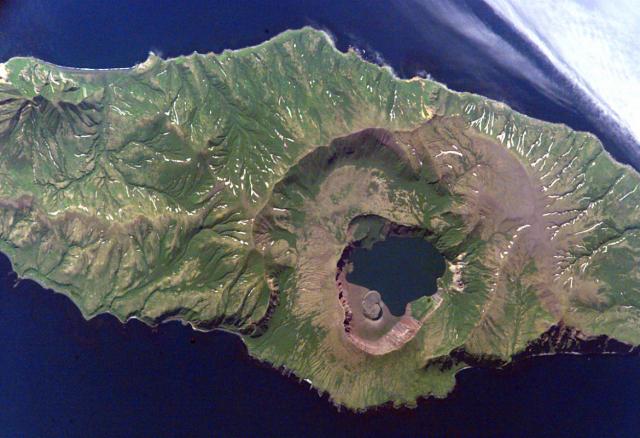
(stratovolcano 551 m / 1,808 ft)
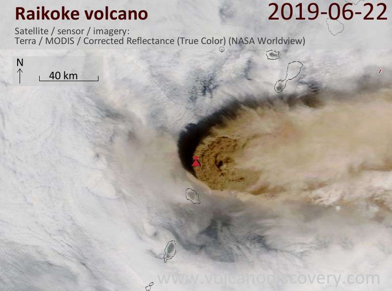
Eruption plume of the 21 June 2019 eruption seen from satellite on 22 June
Raikoke (or Raikoki) volcano is mainly basaltic and has a 700 m wide and 200 m deep crater with steep walls. Raikoko has erupted lava flows all along the eastern side of the island.
A large eruption occurred in 1778 which destoryed the upper third of the island. Another str... [
more info]
(stratovolcano 956 m / 3,136 ft)
Rasshua is a large volcano forming the 6 x 13 km elongated Island of Rasshua in the central Kuriles. Rasshua volcano is truncated by a large caldera whose eastern rim is below sea level. There are 2 young active central cones in the caldera, from where most activity in the recent... [
more info]
(stratovolcano 1496 m (4,908 ft))
Sarychev volcano is one of the most active volcanoes in the Kuril Island chain streching between Kamchatka and Japan. Large explosive eruptions occured between 11-19 June 2009, sending huge ash coulds to altitudes of up to 14 km, and forcing many flights with routes accross the n... [
more info]
(submarine volcano 36 m / 118 ft)
Srednii volcano is a mostly submarine volcano in the central Kurile Islands between Rasshua and Ushishir Islands. Only a few rocks and islets breach the surface of the sea, including flat-topped Khitraya Rock, which could be a young lava dome or the rim of an old caldera.
... [
more info]
(submarine volcano -150 m / -492 ft)
A submarine eruption in 1924 was reported from a location east of Matua Island in the central Kuriles. There is a submarine volcano reaching near the surface of the sea in this location. [
more info]
(caldera 401 m / 1,316 ft)
Ushishur volcano in the central Kuriles has one of the world's most beautiful calderas, forming a almost complete ring rising above the sea. Most of the volcano's edifice is under water, but the submerged part forms 2 small islands.
The southern island contains the summit ... [
more info]
(Hydrothermal field 828 m / 2,717 ft)
Kuntomintar is a Pleistocene andesitic stratovolcano on the southern end of Shiashkotan Island in the central Kuriles. It contains a central cone inside a 4-4.5 km wide caldera. There are no recent eruption, but there is fumarolic activity near the east wall of the caldera and a ... [
more info]
(stratovolcano 934 m / 3,064 ft)
Sinarka volcano is an andesitic stratovolcano on the northern end of Shiashkotan Island in the central Kuriles, Russia. The youngest features are 2 lava domes, which have had small explosive eruptions in historic times. [
more info]
(stratovolcano 2339 m / 7,674 ft)
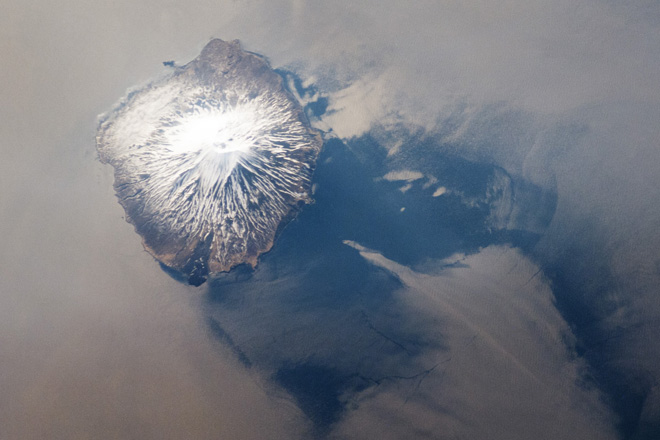
Space image of Alaid stratovolcano (NASA Earth Observatory http://earthobservatory.nasa.gov/IOTD/view.php?id=78290)
Alaid is the tallest and northernmost volcano in the Kurile Islands. Also called Atlasov as the island it forms, the symmetrical stratovolcano rises 3000 m from the sea floor and forms a small island. It has a 1.5-km-wide summit crater breached to the south. It is one of the Kuri... [
more info]
(stratovolcano 724 m / 2,375 ft)
Chirinkotan volcano is a large, mostly submerged stratovolcano forming a small largely unvegetated and 3 km wide island in the Kuril Island chain. It is located at the far end of an E-W-trending volcanic chain that extends nearly 50 km west of the central part of the main Kuril I... [
more info]
(stratovolcano 1170 m / 3,839 ft)
Ekarma stratovolcano forms a small 5 x 7.5 km island 8.5 km north of Shiashkotan Island in the northern Kurile Islands, Russia.
The volcano belongs to an E-W-trending volcanic chain extending westward from the central part of the main Kuril Island arc. It contains two overl... [
more info]
(stratovolcano 1145 m / 3,757 ft)
Kharimkotan (also spelled Harimkotan) volcano is a stratovolcano forming a 8 x 12 km island in the northern Kuriles. Only the upper 25% of the massive volcano rises above sea level. In its geologic past, the volcano has suffered several slope failures and created devastating debr... [
more info]
(caldera 1018 m / 3,340 ft)
Nemo Peak volcano on the northern end of Onekotan Island in the northern Kurile Islands is a complex of 3 overlapping calderas and a young central cone, Nemo Peak, which has been active for about 9,500 years.
It has a 350 m wide summit crater filled by a lava dome with a 1... [
more info]
(stratovolcano 761 m / 2,497 ft)
Shirinki stratovolcano forms a small 3 km wide island 18 km west of Paramushir Island in the northern Kuriles. Most of the volcano is submerged and its peak rises 761 m above the sea. Shirinki volcano has a 750 m wide summit crater with young lava domes at the top, which could ha... [
more info]
(caldera, stratovolcano 1325 m / 4,347 ft)
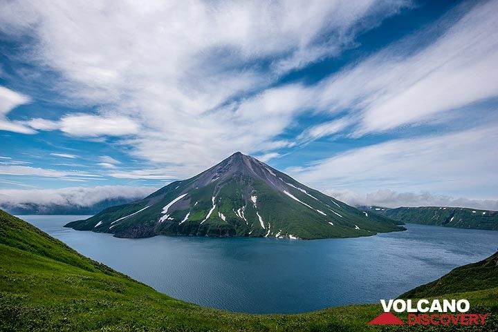
Krenitzyn volcano in the Tao-Rusyr caldera in July 2019
Tao-Rusyr volcano is an impressive basaltic-to-andesitic stratovolcano located on the southern end of Onekotan Island in the northern Kuriles. It contains a 7.5 km wide caldera and a large symmetrical new central cone,
Krenitzyn Peak which is the vent of young activity. A ... [
more info]
(stratovolcano 1816 m / 5,958 ft)
Chikurachki stratovolcano on Paramushir Island (northern Kuriles)
Chikurachki stratovolcano forms highest peak on Paramushir Island in the northern Kurile island arc just south of Kamchatka Peninsula. It is one of the region's most active volcanoes.
The volcano itself is a relatively small cone, compared to other volcanoes of the Kurile I... [
more info]
(somma volcano 1156 m / 3,793 ft)
Ebeko is one of the most active volcanoes in the Kurile Islands, located in northern Paramushir Island south of Kamchatka.
Ebeko volcano has a flat top with 3 summit craters aligned SSW-NNE. The eastern part of the southern crater contains a large boiling spring. The middl... [
more info]
(stratovolcano 1772 m / 5,814 ft)
Fuss Peak is an isolated andesitic stratovolcano on southern Paramushir Island, Kuril Islands. The volcano rises almost 3000 m from the sea floor and forms a peninsula of Paramushir connected to it by a low isthmus.
The volcano contains a 700 m wide and 300 m deep crater, ... [
more info]
(cinder cones 1345 m / 4,413 ft)
Karpinsky volcano is a group of 3 young andesitic cones in southern Paramushir Island, Kuril Islands. The cones are located at the southern end of the Karpinsky Ridge.
The NW cone contains vigorous fumaroles. It has produced a lava flow that flowed 7 km to the SE. The sout... [
more info]
(cinder cones 1681 m / 5,515 ft)
Lomonosov volcano is a group of 4 cinder cones and a lava dome less than 10,000 years old, that were constructed along a N-S. It is located south of Tatarinov volcano in southern Paramushir Island, Kuril Islands. [
more info]
(cinder cones 1183 m / 3,881 ft)
Vernadskii Ridge comprises 3 groups of volcanoes in northern Paramushir Island, Kuril Islands, immediately south of active Ebeko volcano.
The Vernadskii and Bogdanovich groups of volcanoes are the southernmost of this complex and have been active during the past 10,000 yea... [
more info]
(Complex volcano 1910 m / 6,266 ft)
[
more info]
(Stratovolcano 1578 m / 5,177 ft)
Ilyinsky volcano (also spelled Iliinsky volcano) is a conical stratovolcano rising dramatically to 1578 m above the NE shore of Kurile Lake in southern Kamchatka. [
more info]
(Stratovolcano 2156 m / 7,073 ft)
[
more info]
(Stratovolcanoes 900+ m / 2,953 ft)
[
more info]
(Stratovolcanoes 2090 m / 6,857 ft)
[
more info]
(Stratovolcano 1812 m / 5,945 ft)
[
more info]
(Stratovolcano 1079 m / 3,540 ft)
[
more info]
(Complex volcano 2322 m / 7,618 ft)
[
more info]
(Volcanic field 681 m / 2,234 ft)
[
more info]
(Shield volcanoes 719 m / 2,359 ft)
[
more info]
(Shield volcanoes 791 m / 2,595 ft)
[
more info]
(Shield volcano 562 m / 1,844 ft)
[
more info]
(Stratovolcano 1322 m / 4,337 ft)
[
more info]
(Shield volcanoes 700? m / 2,297 ft)
[
more info]
(Shield volcanoes 450+ m / 1,476 ft)
[
more info]
(Stratovolcano 2173 m / 7,129 ft)
Vilyuchik, also known as Vilyuchinsky or Uilyuchinsky, is a steep-sided Pleistocene-to-Holocene stratovolcano that forms a prominent landmark south of Avachinsky Bay. Its last activity dates back to about 10,000 years ago. [
more info]
(Stratovolcano 1234 m / 4,049 ft)
[
more info]
(Stratovolcano 1953 m / 6,407 ft)
[
more info]
(stratovolcano 2882 m / 9,455 ft)
Bezymianny volcano with the steaming lava dome seen from the east
Bezymianny ("unnamed") was considered extinct until it erupted violently in 1955-56, after a slumber of probably 1000 years. It is one of the most active volcanoes in Kamchatka. The eruption followed a massive flank failure (similar to Mt. St. Helens eruption in 1980) which remov... [
more info]
(Stratovolcano 4585 m / 15,042 ft)
[
more info]
(Stratovolcano 4835 m (15,863 ft))
Klyuchevskoy volcano (also spelled Kliuchevsky, Klyuchevskaya) is Kamchatka's highest and one of the world's most active volcanoes.
Klyuchevskoy is located in a remote area of the Kamchatka peninsula. It has a large active crater with frequent strombolian and lava fountain... [
more info]
(Stratovolcano 3283 m (10,771 ft))
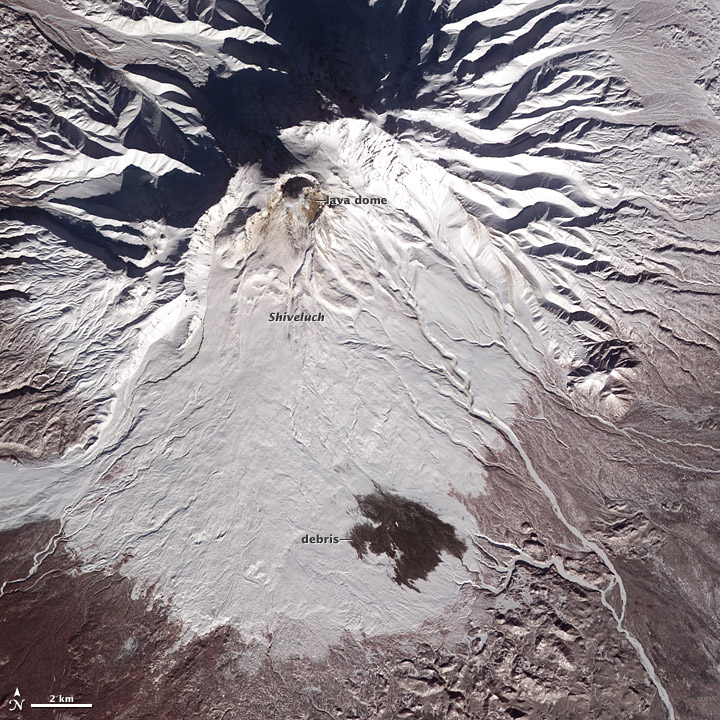
Shiveluch volcano on a Terra satellite image from 19 Feb 2012. Volcanic debris is seen on the lower flanks; the debris traveled about 10 kilometers (6 miles) from Shiveluch’s growing lava dome. (Nasa Earth Observatory)
Shiveluch (Sheveluch) volcano is one of Kamchatka's largest and most active volcanoes, and the one that has had the most violent eruptions. [
more info]
(Shield volcano 3682 m / 12,080 ft)
Tolbachik is one of Kamchakta's largest and most active volcanoes. It is located in the Central depression of Kamchatka 23 km SW of Bezimianny volcano.
Tobachik is formed by 2 overlapping cones, the Ostry Tolbachik stratovolcano and the Plosky Tolbachik shield. In the past... [
more info]
(Stratovolcanoes 2923 m / 9,590 ft)
[
more info]
(Compound volcano 3943 m / 12,936 ft)
[
more info]
(Stratovolcanoes 3081 m / 10,108 ft)
[
more info]


