Cumbal Volcano
Updated: Apr 28, 2024 16:46 GMT -
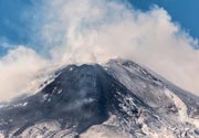
stratovolcano 4764 m / 15,630 feet
Colombia, 0.95°N / -77.87°W
Current status: normal or dormant (1 out of 5)
Colombia, 0.95°N / -77.87°W
Current status: normal or dormant (1 out of 5)
Last update: 15 Dec 2021
Cumbal volcano is an active glacier-capped stratovolcano in SW Colombia, located 25 km SW of Azufral volcano and 5.5 km NE of the town of Cumbal - Pueblo.
Cumbal is the southernmost active volcano of Colombia that has erupted in historic times.
A young lava dome occupies the 250-m-wide summit crater, and eruptions from the upper east flank produced a 6-km-long lava field. Thermal springs occur on the SE flanks.
[smaller] [larger]
Cumbal volcano eruptions: 1926, 1877
Latest nearby earthquakes
| Time | Mag. / Depth | Distance / Location | |||
Background
Cumbal volcano is elongated in a NE-SW direction and composed primarily of andesitic-dacitic lava flows, including many geologically young ones. Over time, the active vents seem to have migrated SW-wards:The 2 active craters, the main crater on the NE side and Mundo Nuevo crater on the SW side have active fumaroles and sulphur deposits and built the summit ridge, while the oldest vents are located NNE of Cumbal and Mundo Nuevo craters.
Eruptions of Cumbal volcano
1988 volcanic unrest
Seismic unrest and an increase in fumarolic activity occurred in 1988, simultaneously with nearby Galeras volcano.
Seismic unrest and an increase in fumarolic activity occurred in 1988, simultaneously with nearby Galeras volcano.
Latest satellite images