| RSS | EN | DE | EL | ES | FR | IT | RU

Volcanoes of Fiji (8)

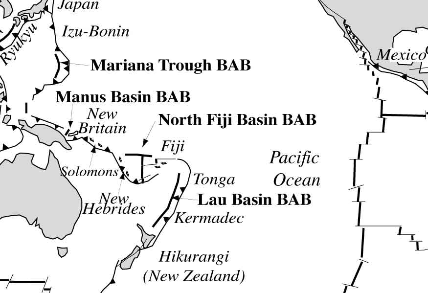
The Fiji Islands are part of an island arc formed by an ancient subduction zone, but the subduction zone is no longer active. At present, they are located in the backarc zone corresponding to the North New Hebrides and New Hebrides Trenches, in an area characterized by several small ocean basins with developing sea-floor spreading rifts. These include the Lau Basin to the east and the North Fiji Basin to the west of Fiji.

Kabara | Katafaga | Koro | Mago | Nabukelevu | Nairai | Taveuni | Waikama
[hide/show quakes] | [smaller] [bigger]

Latest earthquakes: Fiji

In the past 7 days, Fiji was shaken by 1 quake of magnitude 5.9 and 6 quakes between 4.0 and 5.0.
A Magnitude 4.7 earthquake occurred in South Pacific Ocean, Fiji .
Date and TimeMag / DepthNearest Volcano / Location
Jun 10, 11:14 am (GMT -12)
4.7

550 km
275 km (171 mi) W ofSouth Pacific Ocean, 196 km south of Kabara Island, Eastern, FijiI FELT IT Info
Jun 10, 09:47 pm (Fiji)
4.4

598 km
324 km (201 mi) W ofFiji Region  I FELT IT Info
Sunday, June 8, 2025 GMT (2 quakes)
Jun 8, 10:48 am (GMT -12)
4.3

437 km
230 km (143 mi) W of276 km W of Houma, Tonga  I FELT IT Info
Jun 7, 01:41 pm (GMT -12)
4.3

493 km
224 km (139 mi) W of270 km W of Houma, Tonga  I FELT IT Info
Friday, June 6, 2025 GMT (2 quakes)
Jun 7, 08:28 am (GMT +13)
5.9

359 km
254 km (158 mi) SW of296 km WSW of Houma, Tonga  I FELT IT Info
Jun 7, 01:37 am (GMT +13)
4.6

510 km
295 km (183 mi) W ofSouth of the Fiji Islands  I FELT IT Info

Significant Earthquakes in Fiji since 1900


The deadliest earthquake in Fiji since 1900 was the magnitude 6.4 earthquake in  Fiji on Sep, 14, 1953. It resulted in 7 fatalities and 12 injured people. Most casualties and damage resulted from the tsunami that followed the quake. The height of the tsunami waves reached 15 m (49 ft). This was the most disastrous quake in Fiji ever recorded.
A tsunami was generated by the quake as well and contributed to its desctuctive effects. This was the 8th worst quake in Fiji during recorded history. An unknown number houses and other buildings were destroyed and an unknown number damaged.

DateMagRegionDeathsDamage
1979 Nov 166.9Fiji Islands0
moderate
Info
1953 Sep 146.4Fiji Islands7
moderate
Info
1932 Mar 86.2Fiji Islands: Koro, Mudu, Suvasavu0
moderate
Info
1919 Oct 36.9Fiji Islands: Rabi, Tunuloa Mission, Suvasavu0
moderate
Info
Source: NOAA National Centers for Environmental Information (NCEI), Global Significant Earthquake Database. doi:10.7289/V5TD9V7K

Map

Oldest quakes (until 1960) are shown in yellow, most recent (from 2000) in red.
[quakes -] [quakes +] [smaller] [bigger]

Significant Earthquakes in Fiji FAQ

+Which was the deadliest earthquake in Fiji since 1900?

+Which was the earthquake that caused most damage in Fiji since 1900?

+How many people were killed by earthquakes in Fiji since 1900?

+How much damage did earthquakes cause in Fiji since 1900?

Volcano List

Kabara

(Unknown unknown)
[more info]

Katafaga

(Unknown unknown)
[more info]

Koro

(cinder cones 522 m / 1,713 ft)
Koro volcano is a group of young basaltic cinder cones on 16x9 km wide Koro Island between Viti Levu and Vanua Levu, Fiji. Some of the cones are possibly less than 10,000 years old. [more info]

Mago

(Pyroclastic cone(s) unknown)
[more info]

Nabukelevu

(lava domes 805 m / 2,641 ft)
Nabukelevu volcano is an andesitic-dacitic lava dome complex at the SW end of Kadavu Island, Fiji. Its summit is called Mt. Washington. There are flat lava flows at Cape Washington on the west coast and at the Talaulia Bay on the NE coast.
A main hazard from the volcano are... [more info]

Nairai

(Complex 335 m / 1099 ft)
[more info]

Taveuni

(shield volcano 1241 m / 4,071 ft)
Taveuni volcano is a massive, elongated basaltic shield volcano, which forms the 40 km long Tavenui Island, the 3rd largest of the Fiji Islands. Tavenui is known as the "Garden Island" because of its rich volcanic soils.
Tavenui volcano has had at least 36 eruptions since ... [more info]

Waikama

(Complex 760 m / 2493 ft)
[more info]
Volcanoes & Earthquakes - new app for Android
Guaranteed tours
1-17 Aug 2025: Volcanoes and Spices - Sulawesi/Halmahera (Indonesia)
1-14 Oct 2025: Desert, salt and volcanoes - Danakil desert (Ethiopia)
4-12 Oct 2025: From Stromboli to Etna - Sicily and Eolian Islands (Italy)
6-21 Oct 2025: From Krakatau to Bali - Java (Indonesia)
3-19 Nov 2025: Volcanoes and Spices - Sulawesi/Halmahera (Indonesia)
= spaces available   = guaranteed   = few spaces left   = booked out
Backarc basins and plate boundaries in the Pacific Ocean and location of Fiji (BAB)
Microplates and seismicity near the New Hebrides Subduction zone
Volcano news

No news in this list.

Try our free app!
Volcanoes & Earthquakes - new app for Android
Android | iOS version

More on VolcanoDiscovery

Why is there advertising on this site?

Support us - Help us upgrade our services!

We truly love working to bring you the latest volcano and earthquake data from around the world. Maintaining our website and our free apps does require, however, considerable time and resources.
We need financing to increase hard- and software capacity as well as support our editor team. We're aiming to achieve uninterrupted service wherever an earthquake or volcano eruption unfolds, and your donations can make it happen! Every donation will be highly appreciated. If you find the information useful and would like to support our team in integrating further features, write great content, and in upgrading our soft- and hardware, please make a donation (PayPal).

Planned features:Thanks to your past donations, these features have been added recently:
Download and Upgrade the Volcanoes & Earthquakes app to get one of the fastest seismic and volcano alerts online:
Android | IOS
Thank you!
Sources: VolcanoDiscovery / VolcanoAdventures and other sources as noted.
Use of material: Most text and images on our websites are owned by us. Re-use is generally not permitted without authorization. Contact us for licensing rights.
Volcanoes & Earthquakes
VolcanoDiscovery Home
Volcanoes | Earthquakes | Photos | Volcano News | | Shop | App
Adventure & Study Travel
Tours to Volcanoes and Volcanic Areas: walking tours, photo tours, study tours
Tours & Dates | FAQ | About us
Get our newsletter!
Company info
Contact | Legal info | Terms & conditions
Follow us
Follow us on facebook Follow us on Instagram Follow us on Bluesky Follow us on Twitter Visit our Youtube channel
EN | DE | EL | ES | FR | IT | RU
VolcanoDiscovery GmbH, Germany, Reg. nr.: HRB 103744, EU Tax Id: DE 297 465 123 owned and created by
Dr. Tom Pfeiffer, volcanologist, volcano photographer, tour organizer member of
IAVCEI
IAVCEI
Vulkanologische Gesellschaft
Volcanological Society
Ecotourism Greece
Ecotourism Greece
RUV insurance
Insured by R+V
VolcanoDiscovery © 2004- All Rights Reserved | Privacy - Cookie Settings