| RSS | EN | DE | EL | ES | FR | IT | RU

Kasuga 1 Volcano

Updated: Sep 12, 2025 20:08 GMT -
Submarine
Marianas Islands, United States, 21.77°N / 143.71°E
Summit height: -598 m / -1962 ft
Current status: (probably) extinct (0 out of 5)
Kasuga 1 is the northernmost of three seamounts in the Kasuga seamount chain. It rises to within about 600 m of the sea surface. Pumice from a submarine eruption was witnessed in 1959. (Image: NOAA, 2003, http://oceanexplorer.noaa.gov/explorations/03fire/logs/mar02/media/kasuga.html)

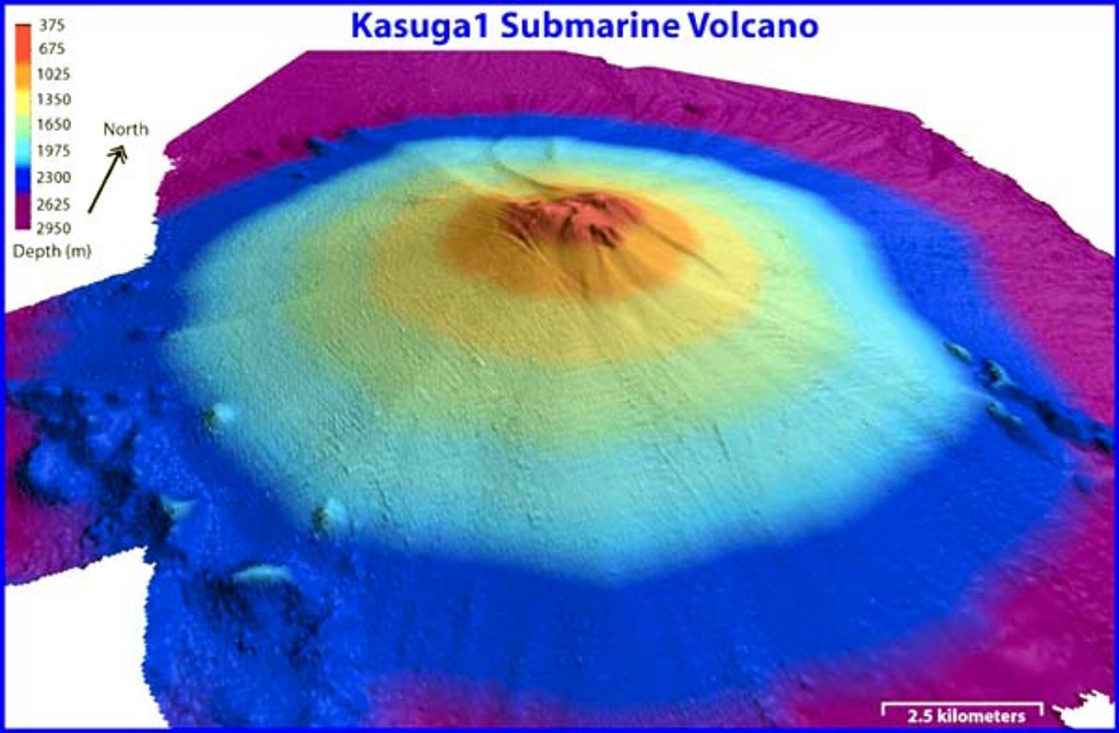
The Kasuga 1 seamount is a conical volcano that rises to within 598 m of the sea surface SE of Fukujin submarine volcano. It was listed as an active volcano by the Japan Meteorological Agency, and floating pumice attributed to a submarine eruption was seen south of the volcano in the summer of 1959.

[smaller] [larger]
Typical eruption style: unspecified
Kasuga 1 volcano eruptions: 1959

Latest nearby earthquakes

Date and TimeMag / DepthDistance / Location

Background

Water discoloration from a possible submarine eruption was reported near the seamount in November 1975. Kasuga, the northernmost of three seamounts in the the Kasuga seamount chain, rises from a depth of 3000 m. A series of flank vents are located low on the southern side of the edifice. The summit does not have a caldera or display hydrothermal activity, and the volcano is largely mantled by volcaniclastics. Altered basaltic and andesitic rocks dredged from the summit suggest that it is the oldest of the three seamounts, although delicately preserved lava flow lobes and toes from a flank eruption suggest a very youthful age.

Significant volcanic eruptions: Kasuga 1 volcano

In the past 10,000 years, Kasuga 1 has had only one confirmed historic eruption in 1959. There is one uncertain or discredited eruption in 1975 from Kasuga 1 volcano.
The table below lists all known eruptions (date in bold face) of Kasuga 1 volcano in historic times and during the past 10,000 years. Updates on the most recent volcanic activity of Kasuga 1 can be found on the news page of Kasuga 1 volcano.
DateNoteVEIDeathsDamage
?? 1975 Nov 16 ±15 d.
Uncertain Eruption
0
1959 Jul 15 ±45 d.
Historical obs./docs.
0
Remark:
Our list of volcanic eruptions closely follows the database of eruptions of the Smithsonian's Global Volcanism Project (GVP), the internationally most recognized data source for volcanic eruptions, but also includes significant eruptive episodes or related volcano events. "Volcanic eruptions" are usually to be understood as sequences of individual eruptive episodes that can follow each other, or even overlap (if several vents are involved), and can last many years, decades or even longer. For example, the current activity of Stromboli volcano is understood as a single eruption that has been ongoing since 1934.
Sources: NOAA National Centers for Environmental Information (NCEI), Global Significant Volcanic Eruptions Database. doi:10.7289/V5TD9V7K | Global Volcanism Project / Smithsonian Institution

Kasuga 1 Volcano FAQ

+When was the last eruption of Kasuga 1 volcano?

+How often does Kasuga 1 volcano erupt?

+How active is Kasuga 1 volcano at present?

Latest satellite images

kasuga1 satellite image sat1kasuga1 satellite image sat2

Kasuga 1 Volcano Maps

Below is a selection of maps showing the location and surroundings of the volcano at various resolutions based on aerial-imagery / terrain maps. Feel free to use them for non-commercial purposes on your blog or website as long as you credit them with a link back to this page (click to copy it).
Satellite/aerial-type map of Kasuga 1 volcano (world scale)
Terrain-type map of Kasuga 1 volcano (world scale)
Satellite/aerial-type map of Kasuga 1 volcano (region scale large)
Terrain-type map of Kasuga 1 volcano (region scale large)
Satellite/aerial-type map of Kasuga 1 volcano (region scale medium)
Terrain-type map of Kasuga 1 volcano (region scale medium)
Satellite/aerial-type map of Kasuga 1 volcano (region scale small)
Terrain-type map of Kasuga 1 volcano (region scale small)
Satellite/aerial-type map of Kasuga 1 volcano (local scale large)
Terrain-type map of Kasuga 1 volcano (local scale large)
Satellite/aerial-type map of Kasuga 1 volcano (local scale medium)
Terrain-type map of Kasuga 1 volcano (local scale medium)
Satellite/aerial-type map of Kasuga 1 volcano (local scale small)
Terrain-type map of Kasuga 1 volcano (local scale small)
Satellite/aerial-type map of Kasuga 1 volcano (scale of 10s of km)
Terrain-type map of Kasuga 1 volcano (scale of 10s of km)
Satellite/aerial-type map of Kasuga 1 volcano (scale of 20-40 km)
Terrain-type map of Kasuga 1 volcano (scale of 20-40 km)
Satellite/aerial-type map of Kasuga 1 volcano (scale of approx. 10-20 km)
Terrain-type map of Kasuga 1 volcano (scale of approx. 10-20 km)
Satellite/aerial-type map of Kasuga 1 volcano (scale of 5-10 km)
Satellite/aerial-type map of Kasuga 1 volcano (scale of few kilometers)
Volcanoes & Earthquakes - new app for Android
Guaranteed tours
6-21 Oct 2025: From Krakatau to Bali - Java (Indonesia)
3-19 Nov 2025: Volcanoes and Spices - Sulawesi/Halmahera (Indonesia)
3-19 Nov 2025: From Krakatau to Bali - Java (Indonesia)
9-19 Nov 2025: Guatemala Volcano Special - Guatemala
20 Nov - 3 Dec 2025: Desert, salt and volcanoes - Danakil desert (Ethiopia)
2-10 May 2026: From Stromboli to Etna - Sicily and Eolian Islands (Italy)
= spaces available   = guaranteed   = few spaces left   = booked out
Latest news

No news in this list.

On this page:

Try our free app!
Volcanoes & Earthquakes - new app for Android
Android | iOS version

More on VolcanoDiscovery

Why is there advertising on this site?

Support Us – Help Us Enhance Our Services!

We’re passionate about delivering the latest volcano and earthquake data from around the globe — just for you. However, maintaining our website and free apps requires significant time, effort, and resources.
Your support helps us expand our hardware and software capabilities and empowers our dedicated editorial team. Our mission is to provide uninterrupted, real-time updates whenever an earthquake strikes or a volcano erupts — and your donations make this possible. Every contribution, big or small, is deeply appreciated. If you find our information valuable and want to help us add new features, create compelling content, and improve our technology, please consider making a donation:

Donate with Card or Apple/Google Pay:

Send €5 payment link to support VolcanoDiscovery with 5 EUR
€10 payment link to support VolcanoDiscovery with 10 EUR
€25 payment link to support VolcanoDiscovery with 25 EUR
€50 payment link to support VolcanoDiscovery with 50 EUR
€100 payment link to support VolcanoDiscovery with 100 EUR
€250 payment link to support VolcanoDiscovery with 250 EUR

Donate with PayPal:

Planned Features:

Thanks to your past donations, we have recently added:
Download the Volcanoes & Earthquakes app to stay among the first to receive the fastest seismic and volcano alerts online:
Android | iOS
Thank you for being part of our mission!
Sources: VolcanoDiscovery / VolcanoAdventures and other sources as noted.
Use of material: Most text and images on our websites are owned by us. Re-use is generally not permitted without authorization. Contact us for licensing rights.
Volcanoes & Earthquakes
VolcanoDiscovery Home
Volcanoes | Earthquakes | Photos | Volcano News | | Shop | App
Adventure & Study Travel
Tours to Volcanoes and Volcanic Areas: walking tours, photo tours, study tours
Tours & Dates | FAQ | About us
Get our newsletter!
Company info
Contact | Legal info | Terms & conditions
Follow us
Follow us on facebook Follow us on Instagram Follow us on Bluesky Follow us on Twitter Visit our Youtube channel
EN | DE | EL | ES | FR | IT | RU
VolcanoDiscovery GmbH, Germany, Reg. nr.: HRB 103744, EU Tax Id: DE 297 465 123 owned and created by
Dr. Tom Pfeiffer, volcanologist, volcano photographer, tour organizer member of
IAVCEI
IAVCEI
Vulkanologische Gesellschaft
Volcanological Society
Ecotourism Greece
Ecotourism Greece
RUV insurance
Insured by R+V
VolcanoDiscovery © 2004- All Rights Reserved | Privacy - Cookie Settings